On July 18, 1853, a settler standing guard at Payson's fort was shot dead, the killing a marker in the town park calls the opening of the Walker War. Antonga Black Hawk, who led the Ute side of the longer war that followed, was buried a few miles away in 1870, on the mountain above Spring Lake. Between those two graves sits most of what made Payson: a creek the Timpanogos called Peteetneet, a fort a fifth of a mile on a side, and the farms, sugar factory and onion fields that grew up once the fighting stopped.
A campsite in 1776
Payson's written history begins with a Spanish expedition. On September 26, 1776, the Franciscan friars Francisco Atanasio Domínguez and Silvestre Vélez de Escalante left Hobble Creek, crossed the Spanish Fork River and camped on the stream now called Peteetneet Creek, according to the bicentennial marker in Payson's Memorial Park. Escalante's diary praised the valley's "splendid advantages." The next day they moved on south toward the salt flats of what is now Juab Valley. The valley around them was the home of the Timpanogos people, who had lived along these creeks for generations.
Nobody from outside stayed for another seventy-four years.
October 1850: seventeen people on Peteetneet Creek
On the evening of October 20, 1850, three families made camp on the creek: those of James Pace, John Courtland Searle and Andrew Jackson Stewart, along with two boys, Allison Hill and Nathaniel Haws. Payson's 1950 centennial history, The Payson Story, compiled for the city's hundredth birthday, counts seventeen people. The Utah History Encyclopedia says sixteen. The difference is probably who was counted, and neither changes the story.
More came quickly. The Daniels family arrived in late November, the Curtis families on December 7, the Gardners late in December. On December 20 the settlers organized a church branch with Pace presiding. The first child born there, Jerushia Morrison Searles (the centennial history spells the family name Searles), lived nine days, from January 30 to February 8, 1851. That is the kind of detail a centennial history keeps and a short summary usually drops, and it says more about the first winter than any statistic.
The creek, and at first the settlement, carried the name Peteetneet. The centennial history says the name meant "Little Water" and came both from the creek and from Chief Peteetneet, who lived in the area. Our things to do in Payson guide covers what is known about Peteetneet himself and his village. The settlers soon renamed their town after Pace: first Pacen, then Payson. The encyclopedia dates the change to 1851; other accounts say 1852.
John D. Lee passed through on December 18, 1850, and his journal entry, quoted on a 2002 trail marker in Memorial Park, describes the low, marshy ground between Spanish Fork and "F.P.," Fort Peteetneet, where loaded wagons sometimes needed nine yoke of oxen to get through the sloughs. He also wrote that the place was lovely and promised to become a fine settlement.
The fort and the first death of the Walker War
The first fort was a picket fence of nine-foot stakes around the cabins, and a larger fort was laid out in mid-March 1851. It was the second that mattered.
In July 1853 the Walker War broke out. Utah's History To Go account, written by historian Thomas G. Alexander, dates its start to July 17, 1853, when a quarrel at James Ivie's cabin near Springville left Shower-O-Cats, a relative of the Ute leader Wakara (often spelled Walkara), dead. The next day, July 18, Alexander Keele, a thirty-one-year-old settler from Tennessee who had come west the year before, was shot while standing guard at Payson. A marker in Memorial Park says he was killed "by an Indian feigning friendship" and calls his death the "opening of the Walker War." History To Go names the man who shot him as Arapeen, and says Wakara's people then withdrew up Payson Canyon, firing on cabins and taking cattle and horses as they went. The centennial history notes that a monument to Keele was dedicated in Memorial Park on August 4, 1931.
So two towns hold a piece of the war's beginning: Springville has the quarrel and Payson has the first settler's death that the state's account records. Both are true.
Brigham Young and Daniel Wells ordered settlers to leave small outposts and gather behind walls. Payson rebuilt its homes in fort style and enclosed them in a square about 60 rods on each side, roughly a fifth of a mile. Markers placed at its corners in 2006 by the Payson Historical Preservation Board describe walls of adobe, rock and mud, 8 feet high, 4 feet thick at the base and 2 at the top, sitting on a rock foundation, with log buttresses at the corners and a trench about 4 feet deep dug around the outside. The centennial history adds that the gates were on the south and east sides and the north wall was never finished.
Young and Wakara met at Chicken Creek in Juab County on May 11, 1854, which ended the immediate fighting. As History To Go points out, it settled nothing underneath. The Utes' land was never bought, and their claim was not paid until the Indian Claims Commission ordered compensation after the Second World War.
A city on paper, and a bigger one than today
Payson was incorporated by the territorial legislature as Payson City, and David Crockett (not the Tennessee frontiersman) was elected first mayor in April 1853. The date of incorporation is usually given as January 21, 1853, by both the encyclopedia and the centennial history. A 1961 Daughters of Utah Pioneers marker in Memorial Park says January 21, 1852. The weight of the sources is with 1853.
The new city was bigger than the one on today's map. According to the encyclopedia, its boundaries took in Spring Lake Villa to the south and Summit to the southwest, the settlement that later became Santaquin. Payson was the anchor of the south end of the valley, and the smaller places around it grew up in its orbit.
Black Hawk's last years at Spring Lake
The Walker War's peace lasted about a decade. In 1865 the Black Hawk War began in Sanpete County and spread across central Utah; Payson's centennial history records Peter Ludvigsen's death in a cattle raid as its local opening and says some twenty-seven settlements were attacked over the next two years. Our page on the Timpanogos people of Utah Valley covers that war and its causes from both sides.
The centennial history says Black Hawk later asked the settlers' forgiveness. He died on September 26, 1870, of tuberculosis and complications of an old gunshot wound, according to a 1996 Deseret News account, and his wives buried him on the mountain above Spring Lake, the small community two miles southwest of Payson, with a horse, a decorated bridle, sleigh bells and an eagle feather.
What happened next is one of the uglier episodes in Utah County's record. Miners dug up his grave, in 1911 by the Deseret News account or 1917 by the federal repatriation notice. His bones ended up on display in the church's history museum, where the federal notice says they were held from 1919 to 1994, and then at BYU's Museum of Peoples and Cultures. A Pleasant Grove teenager named Shane Armstrong, working on an Eagle Scout project, traced them there. Under the federal repatriation law, three descendants of Black Hawk's brother claimed the remains with the support of the Uintah and Ouray Ute Tribe, and on May 4, 1996, Black Hawk was reburied in a pine box in the Spring Lake town park, near his original grave.
Rails, sugar and water
The Utah Central Railroad reached Payson on March 18, 1875, according to the centennial history, giving the farms around it a way to ship to market. The interurban followed much later. Walter C. Orem was granted rights in 1903, but the first electric car from Salt Lake City did not arrive until May 26, 1916; a golden spike ceremony was held in Payson that day, and the line ran until 1946. Our history of the Orem interurban railroad covers it.
May 26, 1916 was a big day for another reason. Payson hosted a two-day celebration, May 26 and 27, for the Strawberry Valley Project, which the centennial history says irrigated about 60,000 acres from Spanish Fork to Goshen. Utah's History To Go account explains the engineering: a concrete-lined tunnel nearly 20,000 feet long, finished in 1912, carried water from a reservoir on the east side of the Wasatch to the head of Diamond Fork, and irrigation water first flowed in June 1915. The encyclopedia credits that water with the town's later population and industrial growth. Our page on the Strawberry Valley Project explains how it worked.
The water fed sugar beets. A sugar factory capable of processing 500 tons a day began running west of Payson in the fall of 1913, and it was dismantled in 1940. In between, Payson was a sugar town as much as anything.
The Golden Onion
The crop the town chose to be known by was onions. The centennial history says Payson adopted the Golden Onion in 1929 at the request of Utah County authorities, and the town has held its homecoming celebration under that name ever since. Golden Onion Days runs through Labor Day.
The downtown that grew up around those crops is still largely there. The centennial history dates a tithing house to 1858, the first city hall, Payson's first brick building, to 1870, an opera house with 507 chairs to 1883, and the Wightman Hotel to 1880. The 1961 DUP marker says the curfew bell in the city hall belfry rang at 9 p.m. for children under twelve. Payson was not only a Latter-day Saint town: a Presbyterian mission and school ran from 1877 to 1910, and the Methodists built the Iliff Academy in 1890. The Payson Historic District, covering much of the old downtown, was added to the National Register in 2007, according to a 2015 Daily Herald history.
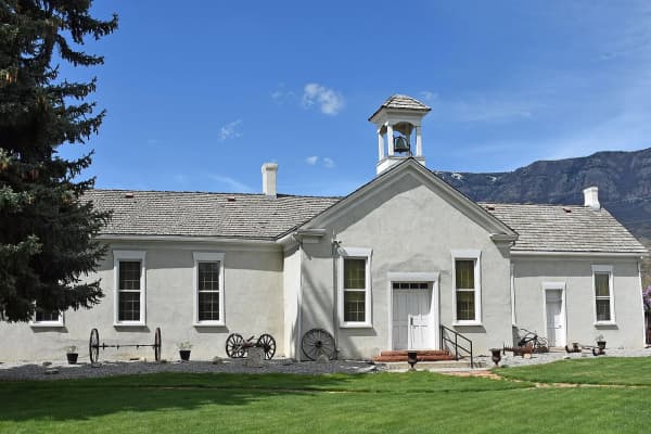
The Peteetneet school opened in 1901 to replace the small neighborhood schools scattered around town, and held classes until 1988. When the city planned to tear it down, a volunteer group called People Preserving Peteetneet saved it.
A city again
For most of the twentieth century Payson grew slowly. The encyclopedia gives 3,998 residents in 1950 and 9,510 in 1990. Then the south end of the valley filled up: the census counted 12,716 people in 2000, 18,294 in 2010 and 21,101 in 2020. On June 7, 2015, Henry B. Eyring dedicated the Payson Utah Temple, the fifteenth in the state, on a 10.6-acre site near the freeway. At the dedication a descendant of the first settlers told the Deseret News that her great-grandfather had planted the apple orchards on the benches, and that the temple's apple-blossom motif made it feel like hers.
See it today
Peteetneet Museum and Cultural Arts Center, 10 North 600 East. The 1901 school on the bluff above Main Street, now a free museum run by volunteers, with an early classroom, a blacksmith shop, local photographs and a statue of Chief Peteetneet on the grounds. The city lists public tours Tuesday through Friday 10 a.m. to 4 p.m. and Saturday 10 a.m. to 1 p.m.; Google's listing in October 2026 showed Thursday as 1 to 4 p.m. Call 801-465-9427 before driving down.
Memorial Park, 250 South Main Street (the park's entrance on Google Maps is listed at 300 South Main). Five markers stand within a short walk of the gazebo: the 1950 centennial millstone, which marks the creek where the first log cabin served as school, church and fort; the 1961 city hall marker; the Escalante bicentennial marker; the John D. Lee trail marker; and the Alexander Keele memorial near the park's 100 West side.
The fort corners. Markers stand at the northeast corner (371 North 200 East), the southeast corner (North 200 East at Utah Avenue) and the southwest corner (West Utah Avenue at North 200 West). The two Utah Avenue markers are about three blocks apart, which gives you a sense of the fort's width.
Payson City Library, 66 South Main Street, in the 1925 building still known as the JC Penney Building, with a 2002 marker.
Black Hawk's grave, in the Spring Lake town park, about two miles southwest of Payson, at 12240 South and Spring Lake Road, the location given when it was dedicated in 1996. It is a grave; visit it that way.
Payson Utah Temple grounds, near the freeway on the city's west side, open to visitors.
For the town as it is now, see living in Payson. For the canyon above it, see the Payson Lakes and Payson Canyon guide.
Frequently Asked Questions
When was Payson founded?
Who was Payson named after?
When was Payson incorporated?
Did the Walker War start in Payson?
How big was Payson's pioneer fort?
Is Chief Black Hawk buried near Payson?
Why are Payson's festivals about onions?
What historic sites can I visit in Payson?
Sources
The facts in this guide were checked against these sources. Hours, fees and rules change, so confirm anything time-sensitive with the source before you go. How we make Provo.com.
- The Payson Story (1950 centennial history), Payson City Historical Society. Checked October 20, 2026.
- Peteetneet Museum, Payson City. Checked October 20, 2026.
- The Walker War, Utah Division of State History, History To Go. Checked October 20, 2026.
- Strawberry Valley Was Utah's First Federal Reclamation Project, Utah Division of State History, History To Go. Checked October 20, 2026.
- Notice of Inventory Completion, Black Hawk remains (61 FR, Jan. 31, 1996), Federal Register. Checked October 20, 2026.
- Peteetneet School, SAH Archipedia. Checked October 20, 2026.
- Alexander Keele, Church History Biographical Database. Checked October 20, 2026.
- In Memory of Alexander Keele, Historical Marker Database. Checked October 20, 2026.
- Dominguez y Escalante Expedition, Historical Marker Database. Checked October 20, 2026.
- Salt Lake to Southern California Road - Peteetneet, Historical Marker Database. Checked October 20, 2026.
- Payson's Pioneer Industry (DUP marker 157), Historical Marker Database. Checked October 20, 2026.
- City Hall (DUP marker 264), Historical Marker Database. Checked October 20, 2026.
- N.E. Corner of Payson Pioneer Fort, Historical Marker Database. Checked October 20, 2026.
- S.E. Corner of Payson Pioneer Fort, Historical Marker Database. Checked October 20, 2026.
- S.W. Corner of Payson Pioneer Fort, Historical Marker Database. Checked October 20, 2026.
- Payson City Library, Historical Marker Database. Checked October 20, 2026.
- Peteetneet Academy & Museum listing, Google Places. Checked October 20, 2026.
- Payson (Utah History Encyclopedia), University of Utah Press / Utah Education Network. Checked October 20, 2026.
- Payson history from promising pioneers to temple development, Daily Herald. Checked October 20, 2026.
- Warrior buried on land he loved, Deseret News. Checked October 20, 2026.
- Black Hawk's remains to rest at Spring Lake, Deseret News. Checked October 20, 2026.
- Payson Utah Temple dedicated, Deseret News. Checked October 20, 2026.
- 2020, 2010 and 2000 Decennial Census redistricting data (P1), U.S. Census Bureau via USAFacts connector. Checked October 20, 2026.