
Every Utah Valley city has a canyon it thinks of as its own, and Payson's is the gentlest of them. The road that starts as a Payson street climbs through oak and maple into aspen and fir, passes a waterfall you can reach with a short walk, and arrives at three small mountain lakes at about 8,000 feet, where the air is cooler and the water is calm enough for a first paddle. Above them, the Nebo Loop Scenic Byway keeps climbing toward the highest peak in the Wasatch Range.
Payson Lakes is the best family lake day in the south end of the valley. This guide covers the three lakes and what each is good for, the day-use area and swim beach, paddling and fishing, the campground and how reservations work, Grotto Falls on the way up, the Nebo Loop's seasonal gates, and how to plan a day that ends back in Payson for dinner.
At a Glance
- Where: About 12 miles up Payson Canyon, just off the Nebo Loop Scenic Byway, in the Uinta-Wasatch-Cache National Forest.
- Elevation: Roughly 8,000 feet, which means cooler summer days and a short season.
- The lakes: Big East, McClelland and Box.
- Facilities: A day-use area on Big East Lake with a small swim beach, picnic tables and flush toilets, and a paved path around the lake.
- Boating: Non-motorized only; powerboats are prohibited.
- Fishing: Rainbow and brown trout, with a Utah license.
- Camping: A developed campground on Recreation.gov, with no hookups and no phone service. Closed for 2026; expected to reopen around May 7, 2027.
- Season: The Forest Service lists the campground season as about mid-May to mid-October, depending on snow; the road is gated in winter.
Getting There: Payson Canyon and the Nebo Loop
From Provo, head south on I-15 to Payson and follow the signs for the Nebo Loop Scenic Byway, which begins in town and climbs into Payson Canyon. The byway runs 38 miles from Payson to Nephi, past Payson Lakes, Devil's Kitchen and the flanks of Mount Nebo, and Payson Lakes sits about 12 miles up from Payson. Our Nebo Loop guide covers the full drive.
The seasonal gates. The Nebo Loop closes with snow every winter and reopens when the road clears. That much is certain; the dates are not. Nephi City, at the far end of the loop, says it closes from late October and can stay closed through June or even July after heavy snow. The gates also close in stages rather than all at once. Before any trip outside high summer, check our canyon conditions page or call the Spanish Fork Ranger District, which manages the road.
The drive itself. The road is paved and climbs steadily, with curves and overlooks. Take it slowly, especially on busy weekends when cyclists, campers and sightseers share the lanes, and use pull-outs rather than stopping in the road for photos.
The Three Lakes
The Forest Service names three waters in the Payson Lakes area: Big East Lake, McClelland Lake and Box Lake. Each has a different personality.
Big East Lake. The largest of the three is where the facilities are. Its day-use area on the shore has a small swim beach, picnic tables and flush toilets, and a paved nature path leaves the parking area and circles the lake. It is the right choice for families with small children, for anyone who wants an easy walk, and for a first paddleboard outing, because you can launch, paddle and picnic without carrying gear far.
McClelland and Box lakes. The two smaller lakes are quieter, with less infrastructure and fewer people. They reward visitors who have been to Big East once and want something calmer, and they are pleasant places to fish or float away from the swim beach. Note the spelling of McClelland, which the Forest Service uses even though many maps and websites drop the final "d."
A Day at Big East Lake
Arrive early. On summer weekends, the day-use parking can fill, and the best picnic spots near the water go first. A morning arrival also gives you calmer water for paddling before afternoon wind.
Walk the loop. The paved path around Big East Lake is flat and easy, which makes it suitable for strollers, grandparents and young children, and it offers views across the water to the forest on every side.
Picnic and play. Bring a cooler, a blanket and a frisbee. The day-use area's tables and nearby restrooms make it an easy half-day with small children, and the swim beach keeps kids busy for hours.
Swim with care. The water at 8,000 feet is cold, even in July, and there is no guarantee of a lifeguard. Supervise children closely, keep weaker swimmers in life jackets, and watch for sudden drop-offs.
Mind the water level. Mountain reservoirs change through the season. Early summer brings full lakes; by late summer the shoreline can be lower and muddier, which changes where the best swimming and launching spots are.
Paddleboards, Kayaks and Canoes
Payson Lakes is one of the best places in Utah Valley for a first paddle. The lakes are small, sheltered and calm, and the ban on powerboats means no wakes and no speeding boats.
Bring your own or rent in the valley. Plan to bring boards and kayaks up with you, or rent them in the valley before you drive. Our kayaking and paddleboarding guide covers where to rent and the rules Utah applies to paddlers, including the mussel-awareness course.
Wear a life jacket. The water is cold enough that a fall can take your breath away. Everyone on a board or in a boat should wear a properly fitted life jacket, and children should never paddle alone.
Watch the afternoon. Mountain weather builds quickly on summer afternoons. If clouds stack up or you hear thunder, head for shore; lightning over open water is a real danger, and wind can make it hard to paddle back.
Fishing
The campground's listing describes fishing for rainbow and brown trout, and the Forest Service includes lake fishing among the area's popular activities. The paved path around Big East Lake makes shore fishing easy, which is one reason the lake is popular with families teaching children to fish. McClelland and Box offer quieter water for anglers who want to get away from the swimmers.
You need a Utah fishing license to fish here. Our guide to fishing and hunting licenses in Utah explains the options, and our guide to kid-friendly fishing ponds covers other easy spots in the valley for young anglers.
Camping at Payson Lakes
The campground. Payson Lakes Campground sits in stands of aspen and fir, with a lake inside the campground where you can boat, fish and swim, and an asphalt walkway around the water. It has single, double and group sites, but no hookups and no phone service, so plan to be unplugged. Loop A is first-come, first-served; other sites must be reserved on Recreation.gov at least five days ahead, with a two-night minimum on weekends. Our camping-when-booked guide explains which sites here are first-come.
The season. The campground is closed for the 2026 camping season with its gates locked, and Recreation.gov says it expects to reopen for 2027 around May 7, 2027. In a normal year its dates depend on snow and on the road, so check the current season on Recreation.gov before you book.
Other camping on the byway. Several campgrounds sit along the Nebo Loop, and dispersed camping is available on the surrounding forest. Check each campground's status before you plan around it. Our guides to camping near Provo and dispersed camping cover the options and the rules.
Camp well. Use existing fire rings and follow any fire restrictions in effect, store food away from wildlife, keep noise down after dark, and pack out everything you bring.
Grotto Falls on the Way Up
About eight miles up the Nebo Loop from Payson, below the lakes, Grotto Falls is the short walk with the big payoff: a mostly level trail to a small waterfall, with a few log crossings along the way. It is an easy stop on the drive up, perfect for young children, and a good way to stretch your legs before the lakes. Our guide to six lesser-known hikes near Provo covers it in detail, including how the walk changes when the winter gate closes and the approach gets longer.
For more waterfalls across the valley, see our guide to waterfalls in Utah Valley.
Beyond the Lakes: Devil's Kitchen and Mount Nebo
Payson Lakes is the Nebo Loop's front door, and many visitors keep going. Past the lakes, the byway climbs toward the Devil's Kitchen, a small area of red, eroded rock formations tucked into the forest, and past trailheads for Mount Nebo. Our Mount Nebo hike guide covers the summit routes, which are serious, high-elevation days. Box Lake, Jones Ranch and Rock Springs leave from the lakes area; our Nebo Loop trail guide covers each.
Out and back or over the top. From the lakes, you can turn around and retrace your route to Payson for a shorter outing, or continue over the top and down to Nephi, returning north on I-15. The full traverse is the better drive; the out-and-back gets you home sooner. If you stop at the overlooks, walk out to Devil's Kitchen and spend any time at Payson Lakes, budget two to three hours for those stops alone.
Seasons at Payson Lakes
Late spring. As the road opens, the lakes fill with snowmelt and the meadows green up. Some facilities may not be open yet, so check before you go.
Summer. Peak season: warm days, cool nights, busy weekends and the best swimming and paddling. Summer wildflowers fill the meadows around the lakes.
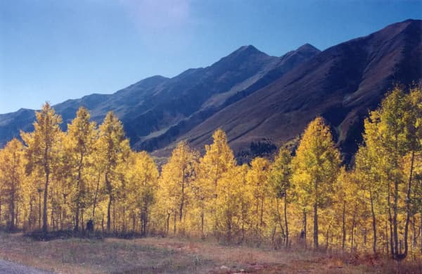
Fall. The Nebo Loop is known for its fall color, which typically peaks from late September into early October. Because the road spans thousands of feet of elevation, it does not all turn at once: the high aspens around the lakes go gold first, and the scrub oak and maple lower down, closer to Payson, turn red afterward.
Winter. Snow closes the road to cars, and the Nebo Loop becomes a route for snowmobiling and snowshoeing. "Closed" means closed to cars, not abandoned. Our snowmobiling guide covers the sport.
With Kids and Dogs
Kids. Between the swim beach, the paved loop, the easy fishing and Grotto Falls on the way up, Payson Lakes is one of the most child-friendly mountain outings in the valley. Pack extra layers, since children get cold quickly at this elevation, and bring water shoes for the rocky shoreline.
Dogs. The lakes are on national forest land, where dogs must be leashed in developed sites such as the day-use area, trailheads and the campground. Keep dogs off the swim beach, pick up after them, and bring water. Our guide to things to do with your dog covers the valley's dog rules.
Photography at the Lakes
Payson Lakes is one of the most photogenic easy places in the valley, and a little timing makes a big difference.
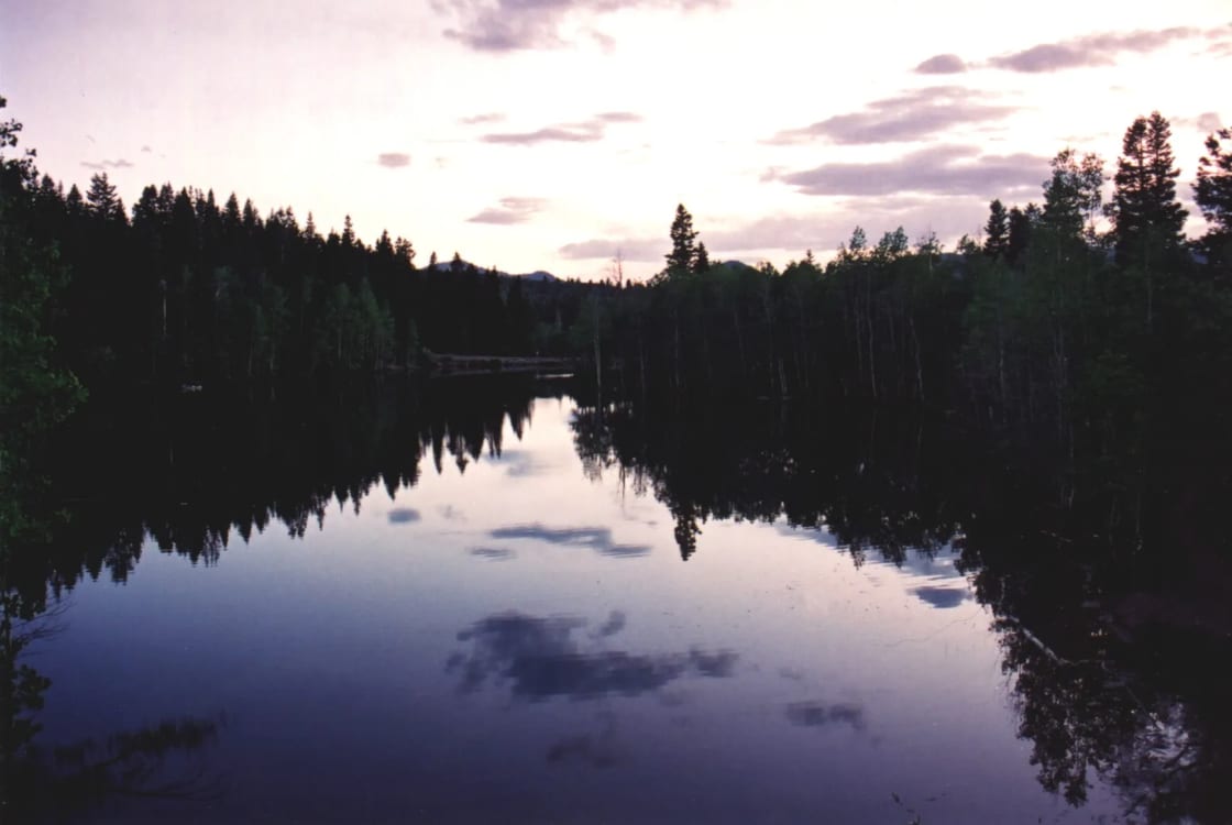
Reflections. The best reflections come early in the morning and at dusk, when the wind drops and the water goes still. The photograph at the top of this page, taken at evening, shows what calm water does with the trees and sky.
Fall color. In late September and early October, the aspens around the lakes turn gold, and the reflections double the effect. Weekday mornings at peak color are worth taking a day off for.
Night skies. At 8,000 feet, far from the brightest valley lights, the sky is darker than it is in town. Campers on clear nights get a much better view of the stars than they would at home.
Wildlife. Deer and other animals come to the water's edge early and late. Keep your distance, use a longer lens, and never feed wildlife.
Accessibility
Big East Lake is one of the more accessible mountain destinations in the valley. The day-use area is close to the parking lot, the restrooms are flush toilets, and the paved path around the lake gives wheelchair users, strollers and anyone with limited mobility a way to enjoy the whole shoreline without rough trail. Campground terrain varies from site to site, so check site details when you reserve if accessibility matters to your group.
Lake Etiquette and Leave No Trace
Share the water. Paddlers should keep clear of the swim beach, and anglers should give swimmers and boaters room to pass.
Keep it quiet. Much of the appeal of a non-motorized lake is the quiet. Keep music low, and respect campground quiet hours.
Pack it out. Carry out all trash, including food scraps and fishing line, which can tangle birds and wildlife.
Follow fire rules. Use only existing fire rings in the campground, and check for fire restrictions, which are common in late summer.
Protect the shoreline. Stay on the path and established access points, since trampled banks erode quickly at high elevation.
A Rainy-Day Backup in Payson
Mountain storms sometimes cancel a lake day. When they do, Payson itself is worth an afternoon. The historic Peteetneet building, a restored schoolhouse, anchors the town's history, and the downtown has a film history of its own, which our guide to movies and TV filmed in Utah Valley explains. Our guide to things to do in Payson covers the town's museums, parks and restaurants, and our guide to living in Payson explains the city behind the canyon.
What to Bring
- Layers, including a warm jacket for evening, since 8,000 feet is noticeably cooler than the valley.
- Sun protection; the high-elevation sun burns quickly.
- Plenty of water and snacks, since services at the lakes are minimal.
- Life jackets for anyone paddling or swimming.
- Bug spray for evenings near the water.
- A paper map or downloaded directions, since phone service is unreliable.
- Trash bags to pack out what you bring.
Planning a Payson Lakes Day From Provo
Morning. Drive south to Payson and head up the canyon, stopping at Grotto Falls for a short walk.
Midday. Arrive at Payson Lakes, walk the Big East loop, paddle or fish, and picnic in the day-use area. The lakes are the one stop on the byway with real facilities and a comfortable place to sit.
Afternoon. Either head back down the canyon before the afternoon storms, or continue over the Nebo Loop past Devil's Kitchen to Nephi.
Evening. Finish with dinner in Payson or elsewhere in the south end of the valley; our guide to the best restaurants in south Utah County has ideas, and our guide to things to do in Payson covers the town. In late summer and fall, combine the trip with a stop at the u-pick orchards around Santaquin and Payson.
The Short Version
Payson Lakes sits about 12 miles up Payson Canyon, just off the Nebo Loop Scenic Byway, at roughly 8,000 feet. The Forest Service names three lakes: Big East, McClelland and Box. Big East has the day-use area, with a small swim beach, picnic tables, flush toilets and a paved path around the lake; the other two are smaller and quieter. Paddling is non-motorized only, fishing is for rainbow and brown trout with a Utah license, and the campground (closed for 2026, expected back around May 7, 2027) has no hookups or phone service. Grotto Falls is a short, mostly level walk below the lakes. The road closes with snow every winter and reopens on no fixed date, so check conditions before you go, and in fall, time the drive for the aspens.
Related Guides
- The Nebo Loop Scenic Byway
- Things to Do in Payson
- Six Lesser-Known Hikes Near Provo
- Kayaking and Paddleboarding Near Provo
- Camping Near Provo
- Mount Nebo Hike
Frequently Asked Questions
Where are Payson Lakes?
Which lakes make up Payson Lakes?
Can you swim at Payson Lakes?
Can you paddleboard or kayak at Payson Lakes?
What kind of fish are in Payson Lakes?
Does it cost anything to visit Payson Lakes?
When is the road to Payson Lakes open?
How far up the canyon is Grotto Falls?
Sources
The facts in this guide were checked against these sources. Hours, fees and rules change, so confirm anything time-sensitive with the source before you go. How we make Provo.com.
- Recreation.gov (Uinta-Wasatch-Cache National Forest): Payson Lakes, Recreation.gov (Uinta-Wasatch-Cache National Forest). Checked October 12, 2026.
- Payson Lakes Campground, USDA Forest Service, Uinta-Wasatch-Cache National Forest. Checked October 12, 2026.
- Scenic Drives – Uinta-Wasatch-Cache National Forest, USDA Forest Service. Checked October 12, 2026.
- Nebo Loop National Scenic Byway, USDA Forest Service, Uinta-Wasatch-Cache National Forest. Checked October 12, 2026.
- Mount Nebo Scenic Loop, Nephi City. Checked October 12, 2026.
- Grotto Trail #086, USDA Forest Service, Uinta-Wasatch-Cache National Forest. Checked October 12, 2026.
- Grotto Falls Trail, AllTrails. Checked October 12, 2026.