Most Utah Valley drivers pass the sign for Kolob Canyons without slowing down. It sits on the shoulder of Interstate 15 in far southwestern Utah, about two-thirds of the way through the long drive from Provo to St. George, and it belongs to Zion National Park even though it looks nothing like the Springdale entrance most people picture. This guide covers where Exit 40 falls on the trip south, what the five-mile scenic road offers, the two trails most visitors choose, and how the area differs from Zion Canyon.
Every hours, fee, closure and trail figure below comes from National Park Service pages checked on November 10, 2026. Park conditions change, and Kolob Canyons Road in particular can close in winter, so treat this as a planning guide and confirm the day-of details at nps.gov/zion before you leave. Where an official page didn't state something, this guide says so rather than filling the gap.
Quick facts
| Item | What the park says | Notes |
|---|---|---|
| Location | Northwest corner of Zion, at Exit 40 on I-15 | About 40 miles north of Zion Canyon and 17 miles south of Cedar City |
| Scenic road | Kolob Canyons Road, five miles long | Ends at the trailhead for Timber Creek Overlook |
| Entrance fee | $35 private vehicle, $20 per person on foot or bike (age 16 and up) | Valid one to seven days; pay or show a pass at the visitor center |
| Visitor center | 8 a.m. to noon, closed noon to 1 p.m., then 1 to 5 p.m. | The hours page lists no separate seasonal hours; confirm before you go |
| Park hours | Open 24 hours a day, every day of the year | Services and roads can still close |
| Pets | Not allowed on any Kolob Canyons trails | Applies to every trail in the section |
| Shuttle | None at Kolob Canyons | You drive the road yourself |
Who this is for
Kolob Canyons works well for a few kinds of visitor.
- Utah Valley residents who want a shorter day. The main Zion Canyon entrance is roughly four and a half hours of driving from Provo, according to our parent guide, Zion and St. George from Provo. Kolob Canyons is the same park with a shorter drive on the same freeway.
- Travelers heading to St. George or Springdale. Because Exit 40 is directly on I-15, it can serve as a leg stretcher with a view instead of a gas-station stop. The five-mile road and a short walk can fit into a break of an hour or two.
- People who dislike crowds and shuttle lines. There is no shuttle at Kolob Canyons, and the road is a short drive from the freeway to its end.
- Families with older children and casual walkers. The Timber Creek Overlook Trail is short, and the NPS rates it easy to moderate with minimal elevation gain.
- Photographers who like red cliffs at low-angle light. The NPS describes a viewpoint and a trailhead overlook along the five-mile road. Check the park's sunrise and sunset page for light timing on the day you go.
Who should skip it
Kolob Canyons isn't the right choice for everyone, and saying so up front saves a long drive.
- First-time visitors who want the famous Zion experience. The Narrows, Angels Landing, Observation Point and the shuttle-served canyon floor are in Zion Canyon, about an hour away by road according to the NPS Taylor Creek page. Kolob Canyons will not stand in for them.
- Anyone traveling with a dog and expecting trail time. Pets are not allowed on any Kolob Canyons trails.
- People who need a lot of services. The NPS lists restrooms and water at the visitor center and pit toilets at the trailheads, but there is no town, restaurant or lodge on the road. Plan food in Cedar City, New Harmony-area stops or St. George.
- Anyone relying on a winter road opening. Kolob Canyons Road may close for snow or ice. If you can't tolerate a closed road, pick a different winter outing, such as the options in our guide to Zion in winter.
- Large groups planning wilderness trail outings. The NPS says groups larger than 12 may only hike the Timber Creek Overlook Trail in this section.
How to get there from Provo
The route is simple because it is almost entirely one road. From Provo, take I-15 south through Utah County, through Nephi and Scipio, past Beaver, and on to Cedar City. After Cedar City, continue south on I-15 to Exit 40. The National Park Service places Kolob Canyons about 17 miles south of Cedar City, which makes the final stretch short.
Our parent guide puts the Springdale entrance at about 263 miles and four and a half hours of driving without stops. Exit 40 is north of that point, so the Kolob trip is shorter, and a mapping app on the day of your drive will give the best live estimate for your route. Traffic in Utah County, construction zones and weather on the stretches through central and southern Utah can change the time.
Practical notes for the drive:
- Fuel up before you leave the freeway. The park road is five miles of scenic driving with no gas. Cedar City is the last large town before the exit.
- Watch the exit. Once you leave I-15 at Exit 40, you stop at the visitor center to show a pass or pay.
- Plan the return. If you are doing a same-day round trip, build in the time to be back on I-15 before dark. Southern Utah winter evenings come early, and the stretch between Cedar City and Beaver can see snow and wind in the colder months.
If you want a longer southern Utah plan that includes more than one park, see our Zion and Bryce long-weekend itinerary, and the hub of day trips from Provo for other ideas that fit in a single day.
Where Exit 40 sits on the drive south
It helps to think of the I-15 trip to Zion as three parts. The first part is the Wasatch Front and Utah County, where the freeway is busy and the exits are frequent. The second part is the long central Utah run through Nephi, Scipio, Beaver and the high desert, where the road is mostly open and the next services can be tens of miles apart. The third part begins at Cedar City, which is the last major city before the park exits.
Exit 40 falls in that third part. According to the NPS, it is about 17 miles south of Cedar City. The visitor center is the first stop after you leave the freeway. Beyond Exit 40, I-15 continues south toward the Zion Canyon turnoff and then St. George.
That placement is the reason Kolob Canyons is useful to Provo drivers. You can see national park scenery without committing to the entire trip to Springdale, and if you are continuing south you pass it anyway. A traveler who leaves Provo at mid-morning can reach the area in the early afternoon, walk a trail, and still make a St. George dinner reservation, though the exact timing depends on stops and traffic.
The scenic drive
The Kolob Canyons Road is five miles long, according to the NPS. It begins at the visitor center and ends at the Timber Creek Overlook trailhead and parking area. Along the way are pullouts and a viewpoint. The NPS Taylor Creek page lists pit toilets at the Kolob Canyons Viewpoint, so you can plan a stop there.
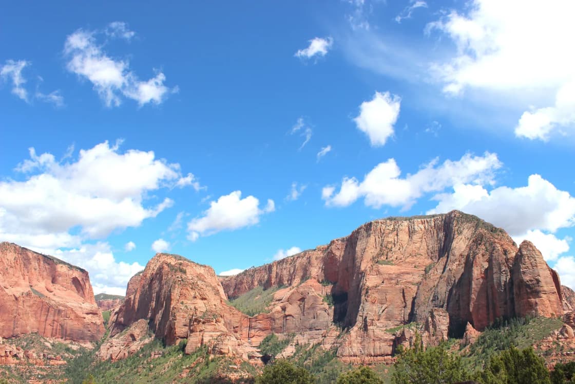
What you see is high red-rock canyon country. The park's own materials describe the Kolob Canyons section as wilderness with more than 20 miles of hiking trails. The setting differs from the main canyon. Instead of a river corridor with a shuttle line, you get a short road that ends at a trailhead and overlook.
A few reminders for the road:
- Winter closures happen. The NPS says Kolob Canyons Road may close in winter due to snow or ice. The park's Current Conditions page says the road is open for most of the year but closes frequently in winter. That page's alerts section is the place to check, and it was not loading live alert data when we looked on November 10, so we can't report today's status.
- Pedestrians and plows. The NPS says pedestrians are not allowed on the road during snow plow operations.
- Take your time. There is no shuttle schedule to meet, so the pace is yours. Still, in cold weather, build in extra time for slow driving.
Timber Creek Overlook Trail
This is the short walk that most first-time visitors choose, and it is the reason many people stop at all.
According to the National Park Service, the Timber Creek Overlook Trail is 0.6 miles one way, an out-and-back that totals about 1.2 miles. The listed time is 30 to 60 minutes. The trail follows a rocky ridge, with about 117 feet of climbing and 103 feet of descent. The park describes it as short and relatively easy with minimal elevation gain, though its assessment also notes grades that reach 38 percent in short places, steps up to 18 inches tall, and a short boulder section where the tread narrows to about six inches.
Some caution is useful here. The park's printed Zion information guide for 2026 lists the trail at about one mile and 100 feet of elevation change, which is a slightly different way of measuring it. The two sources agree on the general shape: a short walk, a small climb, and a ridge setting. For planning, assume roughly an hour with photo stops.
What you see from the overlook, according to the NPS: Shuntavi Butte, Timber Creek, Kolob Terrace, and the Pine Valley Mountains. On a clear day the park says you may see Mount Trumbull, about 100 miles away at the North Rim of the Grand Canyon. The NPS also notes desert wildflowers along the trail in spring and early summer.
Practical details from the NPS page:
- Trailhead: At the end of Kolob Canyons Road, with parking.
- Facilities: Restrooms at the trailhead, water at the visitor center, and a small picnic area a short distance away.
- Surface: About 98.8 percent firm soil and 1.2 percent hard rock. The dirt is often muddy when wet.
- Reservations and fees: No reservation is required and there is no activity fee, but park entrance fees apply.
- Season: The page lists the trail as open year-round at any time of day, although the road to the trailhead can close in winter.
- Groups: This is the one Kolob Canyons trail where groups larger than 12 may hike.
- Pets: Not allowed.
If you have young children, a limited schedule or a mixed-ability group, this is the trail to pick. It is also a sensible choice on a day when you have already spent hours on I-15.
Taylor Creek Trail
Taylor Creek is the longer day-hike option and the one that rewards a bit of planning.
The National Park Service lists the trail at 2.6 miles one way, about 5.2 miles round trip, with a typical time of three to four hours. It rates the hike moderate, with about 799 feet of gain and roughly 373 feet of loss, and it notes that about 31 percent of the trail is 10 percent grade or steeper. The surface is mostly firm soil at about 59 percent, with about 38 percent soft sand.
A note on numbers: the 2026 printed Zion information guide lists Taylor Creek at 5.0 miles round trip, 3.5 hours and 450 feet of elevation change. The online trail assessment gives the longer figure and larger gain. If you are deciding whether the hike fits your day, use the longer numbers, and plan for the full three to four hours.
What the trail offers:
- Creek crossings. The trail follows the Middle Fork of Taylor Creek and crisscrosses the stream inside the Zion Wilderness. The NPS says water levels change seasonally, and that in spring you will likely get your feet wet.
- Two homestead cabins. The park describes two historic homestead cabins from the early 1930s along the route.
- The Kanarraville Fold. The NPS lists this geologic feature among the points of interest.
- Double Arch Alcove. The trail ends here. According to the park's printed guide, it is the destination of the hike.
- Boulder steps and stairs. The assessment lists boulder steps up to about 26 inches tall and staircases with steps up to about 14 inches.
Safety and rules from the NPS:
- Winter conditions can be very icy.
- Use the restroom before hiking, since facilities on the trail are limited. Pit toilets are at the trailhead, the South Fork parking lot and the Kolob Canyons Viewpoint, with restrooms and water at the visitor center.
- Pack out all waste, including toilet paper and hygiene products. The park recommends human waste bags.
- Groups are limited to 12 people sharing the same affiliation, and the limit is strictly enforced.
- No reservations are required, but park entrance fees apply.
- Pets are not allowed.
The park also lists a much longer route, the La Verkin Creek Trail to Kolob Arch, at 14 miles round trip in the printed guide, with a listed time of about eight hours and group size capped at 12. That is a serious outing and is outside the scope of a casual stop. Wilderness permits are not issued at the Kolob Canyons Visitor Center, according to the NPS, so anyone planning an overnight trip should confirm the permit process on the park's website before leaving Utah Valley.
How Kolob Canyons differs from Zion Canyon
The two sections belong to one park, but the experience of each is different. The points below come from the park's own descriptions.
| Feature | Kolob Canyons | Zion Canyon |
|---|---|---|
| Access | Directly off I-15 at Exit 40 | Springdale, then the canyon road |
| Getting around | Drive the five-mile road yourself | Free shuttle runs in the canyon during the season; private vehicles are generally not allowed on the Scenic Drive outside shuttle hours |
| Signature trails | Timber Creek Overlook, Taylor Creek | Includes the Narrows and Angels Landing, which have their own rules |
| Pets | Not allowed on any trail | Check the park's pet rules for each area |
| Permits for day use | None listed for the two trails above | Angels Landing requires a permit past Scout Lookout |
The biggest practical difference is logistics. Zion Canyon runs on a shuttle during the season and has some trails that require permits or are closed. The park's Current Conditions page, last updated September 16, 2026, noted that Hidden Canyon was closed, that the East Rim Trail was partially closed after a large rockfall near Weeping Rock, and that Observation Point could be reached only by hiking from the east. For more on that side of the park, see our Angels Landing permit and hike guide. Kolob Canyons has none of those shuttle rules, though it has its own constraints, mainly the winter road closure and the group-size limits.
The second difference is scale. Kolob Canyons is a short road and a handful of trails. Zion Canyon is a full-day or multi-day destination with a visitor center, a village, lodging and a lot of walking. Many visitors do both: Kolob first on the way south, then Zion Canyon after a night in Springdale or St. George.
Costs
According to the National Park Service's fee page checked on November 10, 2026:
- Private vehicle: $35, valid one to seven days, covering the vehicle and occupants when it carries 15 passengers or fewer.
- Motorcycle: $30, valid seven days.
- Per person on foot or bike: $20 for visitors 16 and older, valid one to seven days. Youth 15 and under are free.
- Zion annual pass: $70, for U.S. citizens and residents.
- America the Beautiful pass: $80 for a resident annual pass, with other categories listed on the NPS page.
- Free days: The page lists November 11 among the 2026 fee-free entrance days, along with a few others earlier in the year. That is the day after this guide's publication date, so confirm it on the NPS site before counting on it.
The fee page doesn't say anything specific about Kolob Canyons. The Kolob Canyons page, however, says all visitors must stop at the visitor center to show an Interagency Park Pass or pay the entrance fee. A Zion entrance receipt is valid for the period printed on it, which the fee page gives as one to seven days for vehicles. Ask a ranger how your receipt applies if you plan to visit both sections.
Beyond entrance fees, budget for fuel, food in Cedar City or St. George, and lodging if you stay overnight. This guide doesn't quote lodging prices because they change by season and event.
Timing and season
The NPS lists the park as open 24 hours a day, every day of the year, and the two main trails as open year-round. That does not mean every condition is the same all year.
- Spring. The NPS notes wildflowers along the Timber Creek trail in spring and early summer, and says Taylor Creek's spring crossings will likely get your feet wet.
- Summer. The park's conditions page says summer daytime temperatures in the Zion area often exceed 100 degrees Fahrenheit, and late-summer monsoon storms raise flash-flood risk. Kolob Canyons sits at a higher elevation than the canyon floor, but the page doesn't give a separate Kolob temperature, so plan for heat and start early.
- Fall. This is a comfortable season for the short trails, though the conditions page doesn't provide specific fall data for Kolob Canyons.
- Winter. The NPS says daytime highs in the area typically range from 30 to 60 degrees, that Kolob Canyons Road may close for snow or ice, and that Taylor Creek can be very icy.
The Kolob Canyons Visitor Center is listed as open 8 a.m. to noon and 1 to 5 p.m. The hours page didn't describe seasonal changes, so check it for the week you travel. If you arrive outside those hours, you can still see the area since the park is open around the clock, but you may not be able to pay the fee in person, and the NPS says all visitors must stop at the visitor center to pay or show a pass. Ask the park how it handles off-hours arrivals if that applies to your plan.
What to bring
- Water. The NPS lists water at the visitor center. There is none on the trails, so carry what you need for the hike you pick.
- Footwear with grip. The Timber Creek trail is described as often muddy when wet, and Taylor Creek involves creek crossings, sand and boulder steps. Winter ice is possible on both.
- Layers. Daytime highs in winter range from 30 to 60 degrees according to the park, and a ridge viewpoint can feel colder than the parking lot.
- A pass or payment. Bring your Interagency pass or a way to pay at the visitor center.
- Sun protection. Hat, sunscreen and sunglasses, especially in the warm months.
- Waste supplies for Taylor Creek. The NPS asks hikers to pack out all waste and recommends human waste bags.
- Offline maps. The NPS pages don't describe cell coverage in Kolob Canyons, so download directions and trail maps before leaving the freeway.
- A charged phone and a paper backup. Park emergencies are reached at 435-772-3322 during daylight hours or 911 at any time, according to the printed 2026 Zion guide.
- Food. There is no restaurant on the scenic road. The NPS lists a small picnic area near the Timber Creek trailhead.
If you plan to fly a drone to photograph the cliffs, read our guide to drone rules in national parks and state parks first.
Safety and conditions
Short trails can still cause problems, and the park's own descriptions point to the main ones.
- Ice and snow. The NPS warns that winter conditions can be very icy on Taylor Creek, and Timber Creek's tread can be narrow in places. If the road is plowed, the trailheads may still be slick.
- Creek crossings. Water levels vary. Don't cross if the creek is running high or the weather is changing. The park's conditions page also notes monsoon-season flash-flood risk in late summer.
- Steps and narrow tread. The Timber Creek assessment lists steps up to 18 inches and a short stretch where the path is about six inches wide. Take care with children.
- Heat. The park notes that summer temperatures often exceed 100 degrees in the Zion area. Start early and carry more water than seems necessary.
- Wilderness rules. Kolob Canyons is designated Wilderness. The NPS says fires are not allowed in the Zion Wilderness except for gas or liquid-fueled stoves, and fireworks are always prohibited.
- Group size. Keep groups to 12 on Taylor Creek and La Verkin Creek, and know that larger groups can only use Timber Creek Overlook.
- Cell service and emergencies. The park pages we read didn't address coverage. Tell someone your route and return time.
What to check before going
- The park's Current Conditions page at nps.gov/zion, for road closures, alerts and weather. On November 10, 2026, the page's live alert section was not loading for us, so we can't state today's road status.
- Kolob Canyons Road status. The NPS says it may close in winter. A closed road means the trailheads are out of reach by car.
- Visitor center hours, listed on the park's hours page.
- Fees and free days, on the park's fee page. Confirm whether November 11 applies to your trip.
- The forecast for Kolob Canyons or New Harmony, Utah, and the forecast for the full drive. Winter storms can close or slow I-15 between Beaver and Cedar City, and UDOT's traffic site is the place to check highway conditions.
- Trail details. The NPS trail pages list assessment dates, and the Timber Creek page was last assessed March 31, 2025. Conditions may have changed since.
- The park phone line, 435-772-3256, for questions the website doesn't answer.
Putting it together
A short Kolob Canyons stop can be as simple as exiting I-15, paying at the visitor center, driving the five-mile road, walking the 0.6-mile path to Timber Creek Overlook, and getting back on the freeway. A longer visit adds the Taylor Creek Trail and its creek crossings, with three to four hours set aside and an early start.
For travelers deciding how Kolob fits into a larger southern Utah plan, our ranking of Utah national parks from Provo can help compare the options, and the parent guide on Zion and St. George from Provo covers the shuttle season and the main canyon in detail.
The short version: Kolob Canyons is the quieter, closer, simpler part of Zion. It will not replace the main canyon, but it is a practical way to see red-rock country from a Provo day trip, and a good place to stop on the way south.
Frequently Asked Questions
Where is Kolob Canyons, and which I-15 exit do I take?
Do I pay the Zion entrance fee at Kolob Canyons?
Is there a shuttle at Kolob Canyons?
How long is the Timber Creek Overlook Trail?
How hard is the Taylor Creek Trail?
Can I bring my dog to Kolob Canyons?
Is the Kolob Canyons road open in winter?
Is Kolob Canyons a good substitute for Zion Canyon?
Sources
The facts in this guide were checked against these sources. Hours, fees and rules change, so confirm anything time-sensitive with the source before you go. How we make Provo.com.
- Kolob Canyons - Zion National Park, National Park Service. Checked November 10, 2026.
- Fees and Passes - Zion National Park, National Park Service. Checked November 10, 2026.
- Hours and Seasons - Zion National Park, National Park Service. Checked November 10, 2026.
- Timber Creek Overlook, National Park Service. Checked November 10, 2026.
- Taylor Creek Trail, National Park Service. Checked November 10, 2026.