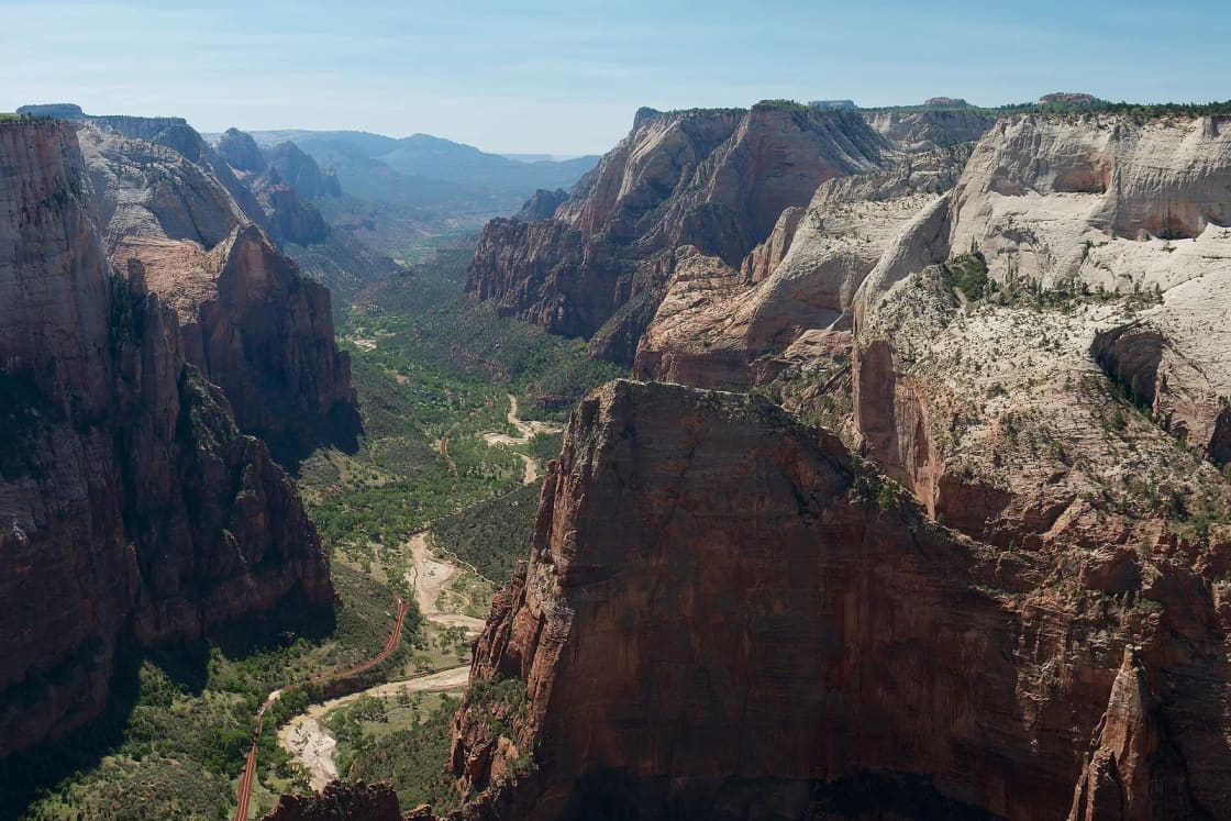
Observation Point is the viewpoint most Zion hikers want after they finish with Angels Landing. It sits about 2,100 feet above the canyon floor according to the Wikipedia article on the point, with a summit elevation of 6,507 feet, and it looks straight down onto Angels Landing without a lottery or a chain. That is the pitch. The catch is that the way most people used to reach it, a steep climb from the Weeping Rock shuttle stop, is closed, and the National Park Service describes that closure as indefinite.
This guide sorts out which trailhead applies, what the NPS says is open as of Nov. 10, 2026, what the park does and does not publish about the route, and who should think twice. It is written for readers in Utah County weighing a long drive south. It leans on NPS pages checked today, flags every place where the official pages are silent, and does not fill those gaps with guesses. The parent guide, Zion and St. George from Provo, covers the wider trip.
What the NPS says today
Trail closure status in Zion changes, and it has changed on this particular route more than once. Here is what the park's own pages said on Nov. 10, 2026.
- The NPS Zion "Current Conditions" page lists Observation Point as unreachable from Zion Canyon and accessible only by hiking from the east. It lists Hidden Canyon as closed, and the East Rim Trail as partially closed after a large rockfall near Weeping Rock.
- The NPS East Rim Trail page says the East Rim Trail is closed from Weeping Rock through Echo Canyon, calls the section "indefinitely closed" because of a major rockfall, and says it is currently not possible to traverse between Zion Canyon and the East Rim. It says the closed section includes the descent through Echo Canyon and the link down the Observation Point Trail to Weeping Rock.
- The NPS trail descriptions page says the East Rim Trail has a long-term closure and that there is no access from the East Rim Trail to Zion Canyon, or the reverse. It lists the Weeping Rock trailhead as closed indefinitely.
Those three statements agree. For a hiker, they mean the Observation Point you can plan around now is the one reached from the plateau on the east side, not from the canyon floor.
One caution about history. Several outside guides say a rockfall closed the Weeping Rock route in 2019. Others place a closure later. The Wikipedia article says only that a major rockfall from Cable Mountain destroyed the lower part of the Weeping Rock trail and does not date it. The NPS pages we opened give no date for the rockfall. We are not repeating a year as fact. What matters for planning is the present tense: the canyon-side route is closed, with no reopening date on the pages we read.
Quick facts
| Item | Detail | Source |
|---|---|---|
| Canyon-side route (Weeping Rock) | Closed indefinitely after a major rockfall | NPS East Rim Trail page |
| East side access | Hike from the east; the only way to reach the point now | NPS conditions page |
| Distance and gain for Observation Point | Not listed on the NPS pages we opened | NPS (gap) |
| Park entrance, private vehicle | $35, valid 1 to 7 days | NPS fee page |
| Best season | Late spring and fall | NPS East Rim Trail page |
| Park information line | 435-772-3256 | NPS |
Two routes, one of them closed
It helps to separate the two ways people have reached Observation Point, because many older blog posts and trail apps still describe the first one.
The canyon route. This is the climb from the Weeping Rock stop on the Zion Canyon Line shuttle. It goes up the East Rim Trail, passes through Echo Canyon, and reaches the point from the canyon side. The third-party site americansouthwest.net describes this as about 4 miles one way, 8 miles round trip, with 2,150 feet of climbing. Its latest dated update on the page is from August 2019 and it says the trail "has been closed for the foreseeable future due to a huge rockfall," so use those numbers as historical context only. The NPS pages we opened do not give a distance or gain for this route. Because the NPS now lists this section as closed, the route is not an option.
The East Mesa route. This approaches from the east side, on the high plateau above the canyon. The NPS trail descriptions page lists East Mesa among the other areas accessible from the East Rim Trail, along with Deertrap Mountain and Cable Mountain. It notes there are no established campsites, that dispersed camping is allowed in select areas of the East Rim, East Mesa, Cable Mountain and Deertrap Mountain mesas, and that a wilderness permit is required for overnight trips. For a day hike, the NPS pages we opened do not name an East Mesa trailhead or describe the approach road.
That silence matters for planning. Park pages describe the East Entrance Trailhead on the East Rim Trail, and they describe the closure. They do not give a turn-by-turn for the East Mesa trailhead, a parking description, or a road rating. Everything specific about that road below comes with a label saying where it is from.
Mileage and elevation: what is official and what is not
The request behind this guide was for mileage and elevation from the NPS. Here is what could be verified.
The NPS East Rim Trail page gives these numbers for the East Rim Trail, which is a different and longer hike than a day trip to Observation Point:
- The trail climbs 1,000 feet onto the rim from the East Entrance Trailhead.
- The closed descent runs 2,300 feet down to the floor of Zion Canyon.
- The first three miles run across the plateau.
- Jolley Gulch is a couple of miles from the East Rim Trailhead and serves as a turnaround for a shorter day hike.
The NPS trail descriptions page lists the East Entrance Trailhead to Stave Spring at 11.8 miles round trip, with 2,300 feet of elevation change, and lists the season as spring and fall. Stave Spring sits near the junction with the Cable Mountain Trail at 6,493 feet, and the NPS says the spring is usually dry by early summer and is not a reliable water source.
None of those figures is the distance to Observation Point from the East Mesa side. The NPS pages we could open do not publish that number. Trail-listing sites and blogs that turned up in search results mostly put the East Mesa route at roughly 6.6 to 7 miles round trip with around 700 feet of climbing, and estimate 2.5 to 4 hours. We could not open the AllTrails listing directly, and these figures are unofficial and not consistent with each other. If you need a number to plan around, ask the park, and treat any single figure as approximate.
A sensible way to hold this: the hike from the east is a plateau walk with a modest amount of climbing compared with the old canyon route, but the length depends on where you start, and where you start depends on road conditions you have to confirm.
Getting there from Provo
The parent guide puts the main canyon entrance at Springdale at about four and a half hours of driving without stops, roughly 263 miles by OpenStreetMap routing, almost all of it on I-15. Observation Point from the east is a different geography. You are approaching the park from the East Entrance on State Route 9, and that entrance is not in Springdale.
The NPS directions page says the park's East Entrance is 13 miles west of Mt. Carmel Junction, reached by driving west on State Road 9. It says the Zion-Mt. Carmel Highway usually has speeds under 30 mph, and that large vehicles are not permitted to drive it between Canyon Junction and the East Entrance. An oversize vehicle or trailer has to use another route, and the NPS links to a large vehicles page for current limits. If you are towing or driving a camper, read that page before leaving Utah Valley.
The NPS directions page does not give drive times from Provo, and we did not verify one. A mapping app will show the best route for the day, and the approach you choose to Mt. Carmel Junction changes the time. One reasonable planning move: if your destination is the east side of the park, set the East Entrance or Mt. Carmel Junction as the waypoint, not Springdale.
Most Utah Valley hikers will treat this as a weekend rather than a day trip, with a night in Springdale, Hurricane, Kanab or St. George. The day trips from Provo hub lists nearer options if the drive is too much, and the ranking of Utah national parks from Provo shows where Zion falls on drive time. If you are building a longer loop, the southern Utah long weekend with Zion and Bryce guide covers a route that includes both parks.
East Mesa trailhead access
This is where the official record is thinnest, so the details below are labeled by source.
What the NPS pages we opened say:
- The park is open 24 hours a day every day, though hours for contact stations, permit offices and campgrounds change seasonally.
- Observation Point can be reached only from the east.
- The East Rim Trail begins at the East Entrance Trailhead, and the NPS East Rim page does not describe road access or conditions.
- The NPS pages we opened do not mention a 4WD or high-clearance requirement for East Mesa, and do not name or describe any private road or private business that provides access.
What an unofficial source says: americansouthwest.net states that the East Mesa Trail ends where it joins a 4WD track at the park boundary, reachable by driving 8 miles north from UT 9. It does not say whether the road is dirt or what clearance is needed, and its dated update is from 2019. Other guides in the search results say the last stretch is rutted and recommend high clearance, but we are not treating that as established.
What that means in practice: if a trail app or a blog tells you a particular road is fine for a sedan, or that a particular private property lets hikers park or charges a fee, verify that independently before you commit. If the approach is a dirt road, as unofficial guides describe, conditions can change with rain and snow. The park's phone line is 435-772-3256, and the NPS conditions page is the first stop for closures. If a road crosses private land, the landowner and not the NPS decides the terms, and the NPS pages we opened do not describe any such arrangement. Ask before you go, and do not assume a gate is open or a lot is available.
Park fees, passes and the shuttle
You pay to enter the park regardless of which side you come in on. The NPS fee page lists:
- $35 for a private vehicle, valid 1 to 7 days, covering up to 15 passengers.
- $30 for a motorcycle, valid 7 days.
- $20 per person for people entering without a vehicle, valid 1 to 7 days. Visitors 15 and under are admitted free, and anyone 16 or older needs a pass.
- $70 for a Zion annual pass, available to U.S. citizens and residents.
- $80 for the America the Beautiful resident annual pass, $20 for a senior annual, and $80 for a senior lifetime pass.
The page lists 2026 fee-free entrance days, and Nov. 11 is one of them. That is tomorrow, relative to the date of this guide. Other fees, such as timed entry or reservations, may still apply, so check before you go.
The shuttle matters less for East Mesa than for the old canyon route, since that route started at Weeping Rock. Still, if you are combining the hike with time in the canyon, the NPS shuttle page lists the following Zion Canyon Line hours for 2026, and says the schedule is subject to change:
- Sept. 13 to Oct. 24: first shuttle at Stop 1 at 7:00 a.m., last at 6:00 p.m., last out of the canyon at Stop 9 at 7:15 p.m.
- Oct. 25 to Nov. 28: first at 7:00 a.m., last at 5:00 p.m., last out at 6:15 p.m.
- Nov. 29 to Dec. 25: no service.
- Dec. 26 to Jan. 2: first at 8:00 a.m., last at 4:30 p.m., last out at 5:45 p.m.
During the stretch with no shuttle, the NPS says private vehicles can usually drive the Zion Canyon Scenic Drive. Our Zion in winter guide covers what that changes. The NPS also warns not to wait for the last shuttle, since a full bus or a missed one can mean a walk of about nine miles.
When to go
The NPS East Rim Trail page says the area is best in late spring and fall, that the trail can get very dry and hot in summer, and that winter snow can last until late spring. The trail descriptions page lists spring and fall. For readers in Provo, that translates into a calendar.
- Late spring. Expect lingering snow or mud on the plateau into the season, and check conditions the day before.
- Summer. The NPS warns about heat. The plateau is higher than the canyon floor, but the pages we opened do not give plateau temperatures, and shade is not mentioned. Start at first light if you go.
- Fall. Shorter days are the main constraint. In mid-November, sunset comes early, so a late start can mean finishing in the dark.
- Winter. The NPS says snow can linger. The access road is the part most likely to be affected, but the NPS pages we opened do not say so, so ask.
A practical note on today's date: it is Nov. 10. The calendar is on the late side for a long, exposed hike with limited daylight, and the shuttle schedule is shrinking. If you are planning a hike this month, treat daylight as your hard limit.
Is it a good hike?
The view is the reason people go. Observation Point sits at 6,507 feet, about 2,100 feet above the canyon floor, and looks down on Angels Landing and the canyon walls. That is a Wikipedia description, not an NPS one, and the NPS pages we opened do not rate or rank the hike.
Reasons it appeals to Utah Valley hikers:
- It does not appear to need a day-use permit, based on the NPS pages we opened, which do not list one for a day hike to Observation Point. Overnight stays in the East Rim area do need a wilderness permit.
- It sits above the crowds on the Zion Canyon shuttle line, though the NPS does not publish crowd data and we are not claiming it is quiet.
- It pairs with the Angels Landing permit guide as a fallback. If you lose the lottery, this is a plausible second choice, as long as you have confirmed the east-side route is open.
Reasons to be less enthusiastic:
- The access is the hard part. Getting to a trailhead on a dirt plateau road, with limited official information, is a bigger variable than the walk itself.
- The mileage is not official. You are planning without a confirmed NPS number.
- The closure history means conditions can shift. A route that is open today can be closed after a storm, and a trail guide that was accurate last year can be wrong this year.
Whether it is the right hike for you depends on how much of that uncertainty you are comfortable with. A reader who wants a predictable day and a lower-effort view of Zion Canyon could choose something on the shuttle line instead. A reader who has driven four and a half hours to the park and wants a major viewpoint might reasonably accept the logistics.
What to bring
The NPS safety page gives the baseline. It says to carry one gallon of water per person per day and drink it, not to drink untreated water, and to avoid instream water because cyanobacteria has been found in the Virgin River, North Creek and La Verkin Creek. The East Rim page adds that Stave Spring is seasonal and often dry by early summer, so plan to carry all the water you need.
From that and the route description, a reasonable list looks like this:
- Water, with a margin, and electrolytes if it is warm
- Food for a long day
- A paper or downloaded map. The NPS East Rim page says to carry a good map and not to build new cairns or take apart existing ones.
- Sun protection, including a hat
- Layers, since the plateau is higher and colder than the canyon in shoulder seasons
- Sturdy shoes with grip for slickrock and sand
- A headlamp, because the NPS warns against being caught after dark on Angels Landing and a late return is the most predictable mistake
- A charged phone with offline maps, but do not count on service
- A full tank of gas and a spare tire if you are taking a dirt road
Who should skip it
Skipping is a normal and reasonable choice. Consider a different hike if any of these apply.
- You cannot confirm the road. If the East Mesa access is unclear and you have no way to ask the park, a shuttle-line hike is a safer bet.
- You are driving a low sedan, towing a trailer or driving a large vehicle. The NPS restricts large vehicles on the Zion-Mt. Carmel Highway, and the NPS pages we opened do not describe the plateau road.
- You are not carrying enough water. The NPS says one gallon per person per day.
- You will start in the afternoon in the fall. Daylight is the constraint.
- You are hiking with a young child who tires easily or a dog. The pages we opened do not set age limits, and we did not find a pet policy for this route, so ask the park before bringing a dog.
- You are uncomfortable on open rock and near drop-offs.
None of that is a criticism. A good alternative is the shorter walk to Scout Lookout, which needs no permit, as covered in our Angels Landing guide.
Safety
The NPS wilderness safety page is blunt. Falls from cliffs on trails have resulted in death. Stay back from edges and be careful on loose sand, pebbles and wet stone, which are very slippery. Flash floods, often caused by storms miles away, can be life threatening, and the NPS advises seeking higher ground if you see cloud buildup, thunder or rising water. Heat exhaustion shows up as nausea, vomiting, fatigue and headaches. The NPS says to rest in a cool, shaded spot and seek medical help if symptoms last more than two hours, and that heat stroke, which can bring confusion and seizures, needs immediate care.
The NPS also says rescue is not a certainty and that help is often hours away. In practical terms, tell someone your route and turnaround time, carry more than you think you need, and turn around if the weather or the clock says to. The NPS says most wilderness trails in the park are out and back, so you can turn around at any point.
What to check before you go
- The NPS Zion current conditions page for closures and alerts, including the Observation Point and East Rim entries.
- The NPS East Rim Trail page to see whether the closed section has changed.
- The park information line, 435-772-3256, for East Mesa road conditions and trailhead access. The NPS pages we opened are silent on both.
- The weather forecast for the park and the plateau, and the sunset time for your date.
- The NPS fee page, including whether your date is a fee-free day.
- The NPS shuttle page if you are combining the hike with canyon stops.
- The NPS large vehicles page if you are driving anything big.
- Any landowner information, if a trail app tells you access crosses private land. Confirm it yourself.
The short version for Utah Valley
Observation Point is a real destination, but for now it is an east-side hike, and the official record on that side is thin. The NPS says the canyon route is closed indefinitely and the point can be reached only from the east. It does not publish a distance or gain for the point, or a road description for the trailhead. Plan the drive around the East Entrance, call the park, carry plenty of water, start early and leave yourself daylight to spare. If the details do not line up, there is no shame in picking another trail and coming back in spring. For the wider trip, start with the parent guide, Zion and St. George from Provo, and for options elsewhere in the state, see Bryce Canyon from Provo.
Frequently Asked Questions
Can I hike Observation Point from Zion Canyon right now?
What is the East Mesa route to Observation Point?
How long is the Observation Point hike?
Do I need a 4WD or high-clearance vehicle for East Mesa?
Does the Zion shuttle go to Observation Point?
How much does it cost to get into Zion for this hike?
When is the best season for Observation Point?
Who should skip Observation Point?
Sources
The facts in this guide were checked against these sources. Hours, fees and rules change, so confirm anything time-sensitive with the source before you go. How we make Provo.com.
- Zion Current Conditions, National Park Service. Checked November 10, 2026.
- East Rim Trail, National Park Service. Checked November 10, 2026.
- Fees and Passes, National Park Service. Checked November 10, 2026.
- Zion Canyon Shuttle System, National Park Service. Checked November 10, 2026.
- Wilderness Safety, National Park Service. Checked November 10, 2026.