
Bryce Canyon is one of the great strange landscapes on earth, and it sits about four hours from Provo. That distance is awkward: too far for a casual Saturday, close enough that Utah Valley residents feel faintly guilty about not having been.
It is worth the drive. It is also a park that people get wrong more often than Zion or Arches, mostly because they underestimate two things — the altitude, and how cold it is.
Fees, road status and seasonal services change. Confirm the current picture with the National Park Service before you travel, particularly outside summer.
What you are looking at
Bryce is not a canyon, technically, and the pedantry is worth a moment because it explains the shape of the place.
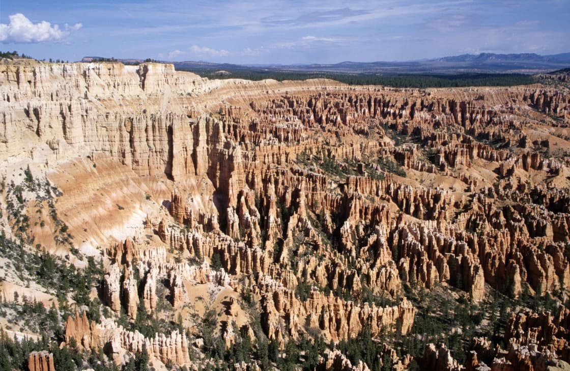
There is no river running through it carving downward. What you are looking at is the eroding edge of a high plateau, worked on by water freezing and thawing in cracks for a very long time, which has broken the rim into a natural amphitheater filled with thousands of thin rock spires called hoodoos.
That is why the viewing works the way it does. At most parks you look up at things. Here you stand on the rim and look down into a bowl of them, which is why the classic photographs all have the same composition and why the first look over the edge is startling.
The drive from Provo
Two routes, and the choice is about what else you want from the day.
The direct approach runs south on I-15 and then cuts southeast toward the park through the high country. It is the faster option and the sensible one if the destination is the point.
The alternative goes further south on I-15 and approaches via the Scenic Byway from the southwest, which passes closer to Zion and makes combining the two natural. It is slower and better scenery.
Either way, budget around four hours and treat that as driving time rather than door-to-door time. Fuel and food thin out considerably once you leave the interstate, so fill up before the last stretch rather than assuming there will be a station.
The fee picture, including what changed in 2026
The National Park Service lists a standard entrance pass in the range of $20 to $35 depending on how you arrive. A private vehicle is $35 and admits the driver and passengers, valid for seven days. Motorcycles are $30, and an individual arriving on foot or by bicycle is $20. An America the Beautiful annual pass, priced at $80, covers entry.
The park is cashless. Cards only, at the fee stations or purchased in advance as a digital pass.
The significant change is for international visitors. From 2026, non-US residents aged 16 and older must pay an additional $100 per person on top of the standard entrance fee at eleven of the most-visited national parks, and Bryce Canyon is one of them — as is Zion. A nonresident annual pass is priced at $250. Children 15 and under are exempt from both the surcharge and the standard fee.
If you are hosting visitors from outside the country, this is a material change to the cost of the trip and worth telling them before they arrive.
The altitude, which is the actual planning constraint
This is the thing that catches Utah Valley visitors, who are already acclimatized to 4,500 feet and assume they will be fine.
The rim at Bryce sits well above 8,000 feet, and the scenic drive climbs higher still. That has three consequences. The air is thin enough that a moderate climb feels harder than the same climb at home. The sun is more intense than the temperature suggests and people burn on cool days. And the temperature itself is far lower than the rest of southern Utah at the same moment.
This last point is the one people plan badly around. It can be hot in St. George and cold at Bryce on the same afternoon. Visitors arrive in shorts in June and find themselves uncomfortable at the rim in the evening.
Bring more layers than seems reasonable. Everyone who has been says this and everyone hearing it for the first time underpacks anyway.
The viewpoints, in order of usefulness
If you have limited time, the main amphitheater viewpoints along the northern end of the park do the heavy lifting. They are close together, they require almost no walking, and they deliver the view the park is famous for.
The scenic drive continues south along the plateau rim to a series of further overlooks, gaining elevation as it goes and ending at the highest points in the park. These are quieter, the character shifts from amphitheater to long-range plateau views, and the round trip takes real time.
A workable strategy: do the main amphitheater viewpoints first, at the beginning or end of the day for light, and then drive the length of the scenic route if you still have hours. If you only get one, take the amphitheater.
The hike everyone should do
The combination of Queen's Garden and the Navajo Loop is the standard first hike at Bryce and it is popular for good reason. It drops off the rim into the amphitheater, walks among the hoodoos rather than looking at them, and climbs back out.
The critical planning fact is asymmetry. The descent is easy and pleasant, and the climb back is a sustained effort at altitude on switchbacks. People walk down feeling excellent and reassess halfway back up. Anybody in the group with cardiac or respiratory limits should be part of that decision before you start rather than after.
Doing the loop in the direction that puts the steeper section on the descent is a common local recommendation, and it is worth checking current trail conditions since sections of these trails close periodically for rockfall and maintenance.
How the hoodoos are made
The mechanism is worth understanding because it explains why the park keeps changing.
Water gets into cracks in the rock. At this elevation the temperature crosses freezing an enormous number of times a year — the park goes through freeze-thaw cycles on many days each year. Each time water freezes it expands and widens the crack fractionally.
Over long periods this splits the rim into narrow walls, then punches windows through those walls, and finally leaves the isolated columns that are the hoodoos. Softer layers erode faster than harder ones, which is why the columns are lumpy rather than smooth, and why many wear a harder capstone.
The consequence is that Bryce is temporary in geological terms. The rim is retreating, hoodoos fall, and the amphitheater you are looking at is a snapshot of a process rather than a permanent feature. Formations that appear in old photographs are gone.
The seasons, compared
Summer is busiest, warmest and the easiest to plan. Afternoon thunderstorms are common on the plateau and the park is crowded at the main viewpoints in the middle of the day.
Autumn is arguably the best combination — thinner crowds after Labor Day, cool clear air, and the light angle improving. Nights get cold early at this elevation.
Spring is variable. Snow lingers, some trails are icy or muddy well into the season, and conditions can differ sharply from one week to the next.
Winter is spectacular and demanding, covered below.
For a first visit from Utah Valley, late September or early October is the window that most reliably rewards the drive.
Wildlife, and the altitude ecology
The plateau supports a different set of species from the desert below it, which is one of the quieter pleasures of the park.
Mule deer are common along the rim, particularly at dawn and dusk. Pronghorn use the meadows in the southern part of the park. The forest holds Utah prairie dogs, a protected species, in colonies visible from the road in the right areas.
Birdlife is notable, including large soaring species that use the amphitheater's thermals, which is one more reason to spend time at a viewpoint rather than photographing and moving on.
The usual rules apply and matter more at a place where animals are habituated to people: do not feed anything, keep distance, and store food properly if you are camping.
Horseback rides, and other ways down
Not everyone wants to walk into the amphitheater, and there is a long-standing alternative.
Guided horseback and mule rides descend below the rim on designated trails, operated under concession. For visitors who cannot manage the climb out on foot, or who simply want a different vantage, it is a well-established option that has been running at Bryce for a very long time.
It requires booking ahead in peak season, has rider weight and age limits, and operates seasonally. If it is the plan that makes the trip work for someone in your group, sort it before you travel rather than on arrival.
The other option is simply the rim trail, which runs between viewpoints along the top and gives you walking, views and no descent at all.
Winter, which is the park's best-kept secret
Snow on orange hoodoos is Bryce's most striking image and comparatively few people see it in person.
The park stays open in winter, the crowds thin dramatically, and the contrast between white snow and orange rock is extraordinary. Some visitors consider it the definitive way to see the place.
The trade-offs are real. It is cold at that elevation in a way that requires proper gear rather than an optimistic coat. Some roads, trails and facilities are affected or closed, and access depends on conditions. The drive from Utah Valley in winter crosses high country that gets weather.
None of that is a reason not to go. It is a reason to check the park's current conditions page before committing, and to travel prepared.
Where to stay
There is lodging inside the park and a cluster of accommodation immediately outside the entrance, plus more in the small towns along the approach.
Staying close pays off for a specific reason: sunrise and sunset are when the rock does what you came to see, and both require being at the rim at inconvenient hours. A twenty-minute drive at dawn is manageable. An hour is the difference between doing it and deciding not to.
In-park lodging and campgrounds book far ahead for summer. If you are planning a peak-season trip, this is the piece to sort first.
The night sky
Bryce is a serious dark-sky destination, and this is an underrated reason to stay overnight rather than day-trip it.
It is remote, high, and dry, which is the combination that produces dark skies, and the park runs astronomy programming. For anyone in Utah Valley who has only ever seen the sky through the Wasatch Front's light dome, the difference is not subtle.
If astronomy is the draw, check the moon phase before booking. A full moon is lovely and it removes most of what you came for.
Doing it with children
The rim is excellent for children. The views are immediate, the walking is optional, and the hoodoos are the kind of landscape that reads as fantastical to a six-year-old without any explanation required.
The amphitheater descent is where judgment is needed. The climb out is a real effort, and a tired child at 8,000 feet becomes a carried child. Rim viewpoints plus a short partial descent and turnaround is the shape that works for most families.
The park's junior ranger programming is well-regarded and gives children a task, which changes the experience from being driven between viewpoints to participating in something.
How to structure the trip
As a long day: leave Utah Valley very early, arrive mid-morning, do the amphitheater viewpoints and one short hike, drive the scenic road, and leave in the late afternoon. It works and it is a lot of driving for the hours you get.
As one night: far better. Arrive in the afternoon, catch sunset at the rim, sleep nearby, do sunrise and the main hike the following morning, and drive home. This is the version most people should do.
As a weekend with Zion: the best value for the distance. Our Zion and St. George guide covers the southern end of that trip, including the shuttle system and the Angels Landing permit lottery, both of which need planning ahead.
Combining it with the rest of southern Utah
Bryce sits within reach of several other destinations that Utah Valley residents tend to see on separate trips, which is inefficient given the drive.
Capitol Reef is the least-visited of Utah's five national parks and pairs naturally with a Bryce trip via the high plateau country. Goblin Valley sits further east and makes more sense combined with Moab.
The general principle: from Utah Valley, southern Utah rewards trips that string destinations together rather than radial day trips out and back. Our day trips guide sorts the region by driving time.
Practical notes
Water is the item to over-prepare. It is dry, it is high, and people underestimate consumption at altitude in cool weather because they are not visibly sweating.
Fuel before the final approach. Cell coverage is unreliable in the park and on parts of the drive, so download maps rather than depending on a live connection. Summer afternoons bring thunderstorms to the plateau, and an exposed rim is the wrong place to be during one.
And check the park's alerts before leaving. Trail closures for rockfall are routine here, and finding out at the trailhead wastes the best part of a morning.
The name, and the quote
The park takes its name from Ebenezer Bryce, a settler who ranched below the amphitheater in the 1870s and for whom the local canyon was informally named.
He is remembered mainly for a remark, widely attributed to him, about the terrain being a difficult place to lose a cow. Whether he said it in those words is the sort of thing that resists verification, but it has survived because it captures something true — before this was scenery it was an obstacle, and the same maze of columns that draws visitors made the country close to unusable for ranching.
That reversal, from worthless ground to protected landscape, is a fairly common story across the Colorado Plateau, and it is worth carrying to the rim.
The short version
Four hours from Provo sits an eroding plateau edge full of hoodoos that looks like nowhere else. Go for at least one night, be at the rim for sunrise or sunset, walk down into the amphitheater knowing the climb out is the hard half, pack far warmer clothes than southern Utah suggests, and tell any international visitors about the 2026 surcharge before they budget the trip.
Related Guides
- Zion and St. George from Provo
- Capitol Reef from Provo
- Best Day Trips from Provo
- Goblin Valley and the San Rafael Swell from Provo
- Moab from Provo
Frequently Asked Questions
How far is Bryce Canyon from Provo?
What does it cost to enter?
What is the new nonresident fee?
How high is Bryce Canyon?
What is the best short hike?
When is the best time to visit?
Can I combine it with Zion?
Is it good for young children?
Sources
The facts in this guide were checked against these sources. Hours, fees and rules change, so confirm anything time-sensitive with the source before you go. How we make Provo.com.
- Bryce Canyon National Park (NPS): Fees & Passes, Bryce Canyon National Park (NPS). Checked October 12, 2026.
- Bryce Canyon National Park (NPS): Hoodoos, Bryce Canyon National Park (NPS). Checked October 12, 2026.