
The short version: Bear River Migratory Bird Refuge is about 101 miles and just under two hours from downtown Provo, by an OpenStreetMap routing estimate (OSRM, no traffic) from Center Street and University Avenue to the refuge's visitor center at 2155 West Forest Street in Brigham City, a quarter mile west of I-15 exit 363. The refuge's pages list no entrance fee. The birds change by the month, and that, more than the weather, is what should decide when you go.
The catch nobody mentions until you are there: the 12-mile auto tour does not start at the visitor center. It starts 12 miles farther west at the end of West Forest Street, out on the Bear River delta. The refuge itself puts the full visit at 36 miles round trip from I-15. From Provo, that turns a two-hour drive into roughly two and a half hours to the first bird you see from the car.
What this place is
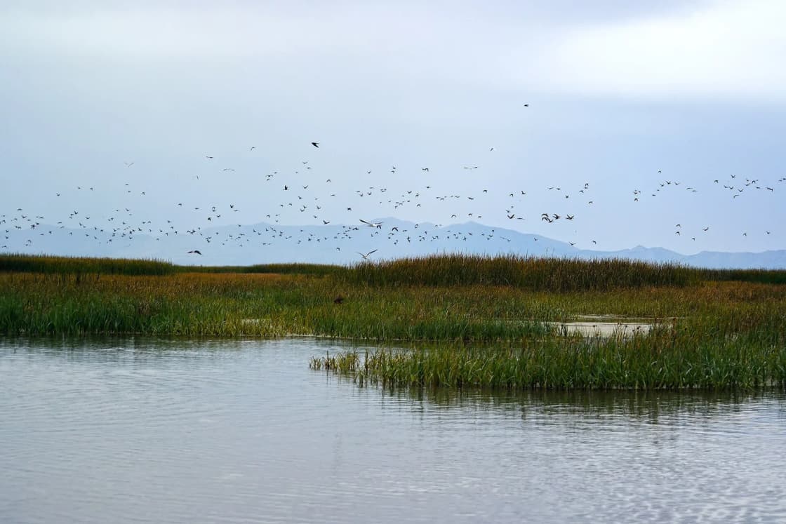
The refuge sits where the Bear River empties into the northeast arm of the Great Salt Lake. The U.S. Fish and Wildlife Service describes its marshes as the largest freshwater part of the Great Salt Lake ecosystem, an oasis surrounded by desert. The refuge covers nearly 80,000 acres of open water, alkali mudflats, marsh and uplands, according to its 2025 brochure.
It was created by presidential proclamation in 1928, after local citizens and conservation groups pushed Congress to act. The brochure gives the reason plainly: marshes were disappearing, and huge numbers of birds were dying from botulism.
Its location is the reason it matters for birds. The refuge lies on the eastern edge of the Pacific Flyway and the western edge of the Central Flyway, so it serves birds using both migration routes. More than 250 species use it, and 67 of them nest there. It is also a Western Hemisphere Shorebird Reserve Network site, a designation for shorebird areas of global importance.
The calendar: which month brings which birds
This is the question that decides the trip, so here is the refuge's own timeline, in order.
| When | What the refuge says to expect |
|---|---|
| Early March | Geese and ducks begin to arrive |
| Early April to mid-May | Spring shorebird migration, birds in breeding plumage and courtship displays |
| May to July | Canada goose goslings first (May), then ducklings and young avocets and stilts (June, July); western grebe chicks riding on their parents' backs in July |
| Late July to mid-August | Fall shorebirds return; numbers peak in mid-August |
| Fall | Up to half a million ducks and geese concentrate on the refuge |
| Mid-October to December | More than 30,000 tundra swans |
| December to March | Northern harriers, rough-legged hawks, prairie falcons, and bald eagles feeding and resting by day |
The spring flyway
From early April through mid-May, shorebirds pass through in their brightest colors. The refuge says each day brings something different, and that observant visitors can watch courtship rituals. Two birds define the refuge in late spring: American avocets and black-necked stilts, which the refuge says nest "by the thousands" along its dikes and roads. White-faced ibis nest in colonies of up to 10,000 birds in the dense marsh vegetation.
For a BYU or UVU student, spring is the easy window. A Saturday in late April or early May falls after finals for most, before summer jobs start, and inside the shorebird migration.
The fall flyway
Fall at Bear River is two separate events.
The first is shorebirds, from late July through August, peaking in mid-August. The refuge's brochure says that by late summer "millions of shorebirds" stop at its insect-rich marshes and mudflats to refuel before flying south.
The second is waterfowl and swans. The refuge says up to 500,000 ducks and geese gather in fall, and tundra swans start arriving in mid-October, more than 30,000 of them, staying through December. If you have one fall Saturday to give this, mid-October through November is the swan window.
Fall also brings hunters. The refuge's Sept. 23, 2026 update noted that Utah's Northern Zone waterfowl season began Saturday, Oct. 3, and parts of the refuge are open to waterfowl hunting during state seasons. Expect to hear shotguns from the hunting units on fall mornings, and check the refuge's site for which areas are open.
Winter
From December through March the marsh freezes and the birds of prey arrive: northern harriers, rough-legged hawks, prairie falcons and bald eagles. Fewer species, bigger birds, and far fewer people. The gravel road is at its bumpiest in winter, by the refuge's own description, but it stays open to ordinary cars when conditions allow.
Driving the auto tour
The Auto Tour Route is how most people see the refuge. The essentials, from the refuge's pages:
- 12 miles, one way, counterclockwise. Pull over to let others pass when you stop to watch or photograph; there are designated pull-offs for this.
- 25 mph. Most of the time you will be going much slower.
- Gravel, bumpy in winter, passable for two-wheel-drive cars, buses and RVs year-round.
- Open sunrise to sunset. A security gate at the start closes at dusk. Do not start the loop late in the day in winter.
- Get out only in designated areas. Your car is the blind. The refuge's photography page says so directly: use your car as a blind on the route, or the photography blind on the walking trails.
- Bathrooms only at the start. There are restrooms at the parking area where the route begins and none after.
- An audio tour is available from the refuge's website to play as you drive.
The refuge says morning and early evening are generally best for watching wildlife. From Provo, that argues for leaving around 6 a.m. in spring, or planning to arrive by mid-afternoon in fall and drive the loop as the light goes golden.
The 2026 detour
From April 4 through mid-September 2026, the regular auto tour route was closed while the refuge replaced water control structures. In its place the refuge opened an alternate 12-mile, one-way route along the O-Line Canal Road and D-Line Canal Road, which normally are closed to the public and run toward the Great Salt Lake. The refuge said the alternate route would show visitors nesting birds such as American avocets that are not usually seen from the regular loop.
The February 2026 announcement said the regular route and Unit 2 would reopen by the start of northern Utah's youth waterfowl hunt weekend. Before you drive two hours, call the refuge at (435) 723-5887 to confirm which loop is open; maps of whichever route is in use are at the kiosks and the visitor center.
Water is the other variable. The same fall 2026 update described ongoing drought in northern Utah and limited water on parts of the refuge. Low water changes where birds gather, which is one more reason to stop at the visitor center first and ask what is being seen.
The visitor center, and the walk behind it
The Wildlife Education Center at the I-15 end is open Tuesday through Saturday, 10 a.m. to 4 p.m., closed on federal holidays (refuge website, October 2026). Inside are exhibits on the Great Salt Lake's birds and wetlands, a wetland diorama, a film called "Wings of Thunder," and a small nature store. Children can earn a Junior Ranger badge or Junior Botany and Junior Ornithology pins.
Behind the building are three trails that start at the parking lot and end on the back patio in a large U:
- Wetland Wonders, a half-mile paved trail with a floating dock
- Bulrush Bridge, three-quarters of a mile
- Marsh Meander, a mile and a half
The refuge counts about a mile of accessible trail and another 0.7 mile of gravel. Leashed dogs are allowed, with waste stations at the trailhead and near the outdoor classroom. The trails, like the auto tour, are open sunrise to sunset every day.
If you arrive on a Sunday or Monday, the building is closed, but the trails and the auto tour are not. That makes a Monday holiday (when the center is also closed) a perfectly good day for the loop, just without the exhibits or a staff member to ask about recent sightings.
Biking it
Bicycles are allowed on all public roads at the refuge, including West Forest Street and the auto tour. The refuge's numbers: 12 miles from the visitor center to the start of the route, 12 miles around, and 12 miles back. A 36-mile flat ride with almost no traffic is a real option for a fit rider, but there is no water and no shade on the delta, and only the one bathroom stop at the start of the loop.
Planning the day from Provo
Leaving early, spring:
- Leave Provo around 6 a.m.
- Drive straight past the visitor center (it opens at 10) and out the 12 miles of West Forest Street to the auto tour.
- Drive the loop slowly through the morning.
- Come back to the visitor center after 10 for the exhibits and the Marsh Meander trail.
- Lunch in Brigham City, then home.
Afternoon, fall:
- Leave Provo around noon.
- Visitor center and a short trail by about 2 p.m.
- Out to the auto tour by mid-afternoon; finish before the gate closes at dusk.
Pairing it. Golden Spike National Historical Park is west of Brigham City by way of State Route 83 through Corinne; our Spiral Jetty and Golden Spike guide covers that day. Ogden is on the way home on I-15. If the refuge leaves you wanting more birding closer to home, the new Provo River delta wetland is on the edge of Provo; see our Utah Lake and Provo River delta birding guide. For another Great Salt Lake wildlife day, Antelope Island is closer and has bison.
What to bring
- Binoculars, or a camera with a long lens. Much of what you see will be well off the road.
- A full tank before you leave I-15. There are no services on West Forest Street or the delta.
- Water and food. None is sold on the auto tour.
- Bug spray in summer. Marshes and mudflats are insect-rich by design; that is why the shorebirds stop.
- A printed or downloaded refuge map, since phone coverage on the delta should not be counted on.
Hunting and fishing follow state rules and seasons; the refuge's fishing brochure says the main catch on the Bear River channel is catfish and carp. If you plan to do either, read the refuge's hunting and fishing brochures and the Utah Division of Wildlife Resources guidebooks first.
Where this fits among day trips
Bear River is an easier day than most of our day trips from Provo: interstate the whole way to the visitor center, a gravel road a two-wheel-drive car can handle, no fee listed, and no hike required. It rewards timing more than effort. Go in early May for shorebirds in breeding color, in mid-August for the fall shorebird peak, or from mid-October through December for the swans. For photographers, our Provo photography spots guide covers the light closer to home.
Frequently Asked Questions
How far is Bear River Migratory Bird Refuge from Provo?
Does it cost anything to visit Bear River refuge?
When is the best time of year to see birds at Bear River?
What are the visitor center hours?
Is the auto tour road paved?
Are there bathrooms on the auto tour?
Can I bring my dog?
Is the regular auto tour route open in 2026?
Sources
The facts in this guide were checked against these sources. Hours, fees and rules change, so confirm anything time-sensitive with the source before you go. How we make Provo.com.
- Bear River Migratory Bird Refuge (home page, visitor center hours, hunt conditions update), U.S. Fish and Wildlife Service. Checked October 19, 2026.
- U.S. Fish and Wildlife Service: Visit Us, U.S. Fish and Wildlife Service. Checked October 19, 2026.
- Tours: Self-guided Auto Tour Route, U.S. Fish and Wildlife Service. Checked October 19, 2026.
- Facility Activities (auto tour, birding, photography, biking, dog walking), U.S. Fish and Wildlife Service. Checked October 19, 2026.
- Birding at Bear River Migratory Bird Refuge, U.S. Fish and Wildlife Service. Checked October 19, 2026.
- Bear River Migratory Bird Refuge General Brochure (August 2025), U.S. Fish and Wildlife Service. Checked October 19, 2026.
- Bear River Migratory Bird Refuge opens alternate auto-tour route during closure to repair road (Feb. 27, 2026), U.S. Fish and Wildlife Service. Checked October 19, 2026.
- OSRM route service (OpenStreetMap data), driving estimates from Center St & University Ave, Provo, Project OSRM. Checked October 19, 2026.
- Google Places listing: Bear River Migratory Bird Refuge Center (address, coordinates), Google. Checked October 19, 2026.