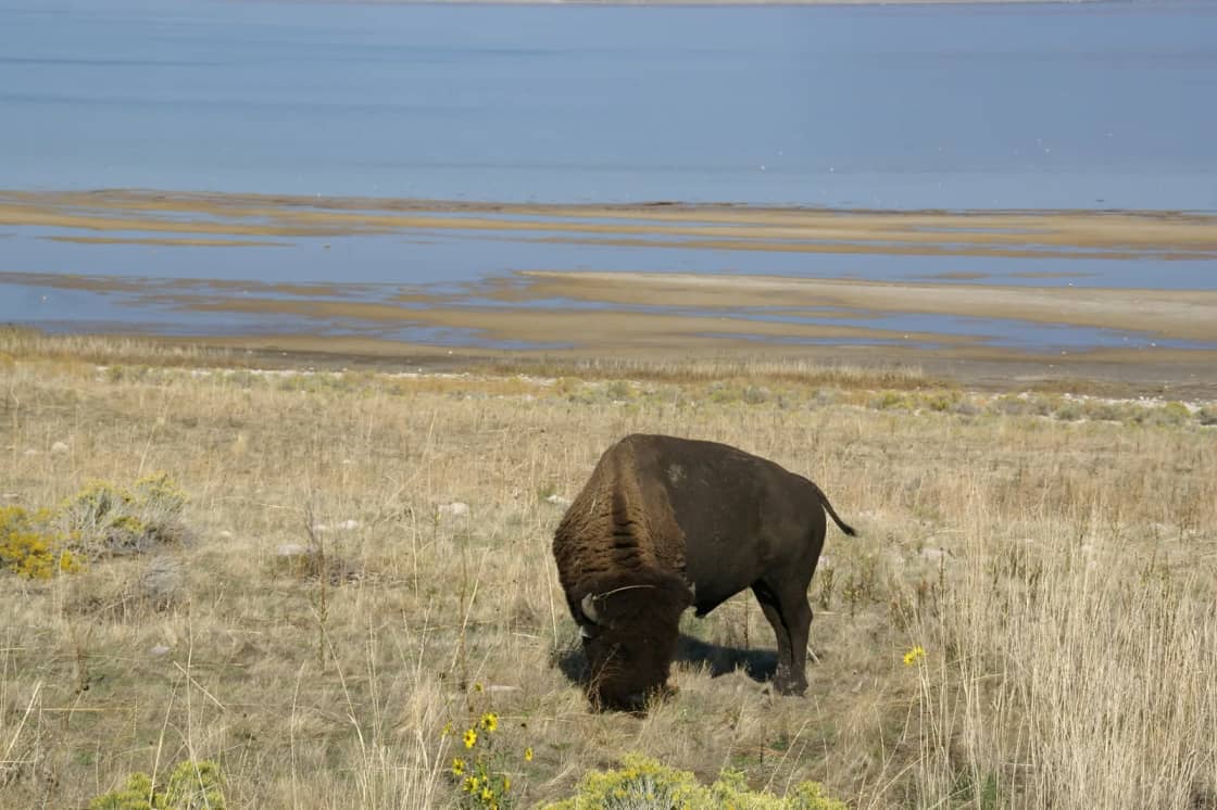

Ninety minutes north of Provo there is an island in a lake that is too salty for fish, carrying a herd of several hundred bison, reached by a seven-mile road across open water.
It does not particularly look like Utah. It does not look like much of anywhere. And a startling number of people who have lived in Utah Valley for years have never made the drive.
The fee that catches almost everybody
Start with the thing that causes the most friction at the gate, because it is structural rather than seasonal and it will not change.
Antelope Island is a Utah State Park. The causeway to it is owned by Davis County. Those are two different entities charging two different fees, collected at the same booth, and the distinction is invisible until it costs you money.
If you hold the Annual State Parks Day Use Pass, it covers the state park entry. It does not cover the $2 Davis County causeway fee — Utah State Parks says so in plain language in its own fee listing. Pass holders roll up expecting to wave and drive through, and get asked for money.
There are two clean solutions. Buy the separate causeway sticker, or buy the Antelope Island Annual Pass, which bundles the causeway fee in. If Antelope Island is a place you will visit more than twice in a year, the island-specific pass is the one that makes sense.
For everyone else, the shape of the cost as published by Utah State Parks is $15 per vehicle for up to eight people for day use, with lower rates for seniors, motorcycles, and anyone arriving on a bicycle or on foot — plus the causeway charge. Camping is priced separately and includes entry.
Fees move. Check the park's own page before you drive. The two-charges-not-one point is the durable part.
Getting there from Provo
The route is simple enough to describe in a sentence: I-15 north to Exit 332, west on Antelope Drive through Syracuse for roughly seven miles, pay at the booth, then seven more miles west across the causeway.
Some notes that matter more than the directions:
Budget two hours, not ninety minutes. The driving time is about right at 75 to 80 miles, but the causeway is a slow, narrow, two-lane crossing with pull-outs, and you will stop on it. Everyone stops on it. The water on both sides of a road with no land in sight is the first strange thing about the trip.
All fees are collected before the causeway, at the mainland end. There is no second booth.
Fuel and food before you cross. The island has limited services and they keep their own hours. Syracuse is your last reliable stop.
Check the road status in winter. The causeway stays open year-round in normal conditions, but weather closes island roads and conditions on the island can be considerably worse than on the mainland.
Our day trips from Provo guide covers how this fits against the other directions you could drive on a Saturday.
The bison, and how to behave around them
The herd is the reason most people come, and it deserves more than a mention.
These are free-roaming animals on a 28,000-acre island, not a wildlife park display. There is no fence between you and them. They walk on the road, they stand in the road, and they are entirely uninterested in your schedule. Utah State Parks manages the herd toward a sustainable population, and it numbers 550 to 700 animals, according to the park.
An adult bull can approach a ton. They look slow. They are not slow, and they turn faster than an animal that size has any right to.
The rules that matter:
- Keep serious distance. The park publishes a minimum and it is larger than instinct suggests. If an animal changes its behavior because of you, you are too close.
- Stay in your vehicle when they are near the road. The car is the best hide you will ever get, and the photographs from inside it are better anyway.
- Never get between an adult and a calf, and never approach a lone bull.
- A raised tail is a warning sign, not a photo opportunity.
Bison are not the only wildlife. Pronghorn, mule deer, bighorn sheep and coyotes all live here, and the island is a significant stop for migratory birds — which is a subject in itself and a reason the birding community takes the Great Salt Lake seriously.
The October roundup, which is a genuine spectacle
Once a year the park rounds the entire herd up on horseback, drives it north into corrals, and works the animals for health checks over the following days.
It is not a re-enactment. It is actual range management that happens to be extraordinary to watch — hundreds of riders moving several hundred bison across open country.
Utah State Parks has published the 2026 main push as Saturday 24 October 2026, with the working of the animals following over subsequent days. Historically an online auction of surplus animals follows.
Two ways to attend:
As a spectator, which requires no registration. There is a designated viewing area, typically at White Rock Bay, with food vendors and educational booths. Bring a camp chair. Arrive early — this is the single busiest day of the park's year and the entrance queue reflects that. The roundup has historically finished somewhere between midday and mid-afternoon, but these are wild animals and the park is explicit that it cannot promise a schedule.
As a rider on the range ride, which requires advance registration, a fee, your own horse, and being at least 18. Registration closes in advance and the park does not make exceptions.
Confirm dates with the park directly. They shift, and a roundup weekend is a bad thing to guess about.
When to go, honestly
Spring (April–May) and autumn (September–October) are the answer for most people. Comfortable temperatures, active wildlife, less bug pressure, and the light is better.
Summer is hot with little shade, and it is when the biting gnats are worst. It is also the only sensible time to float in the lake, so the trade is real.
Winter is underrated — snow-dusted bison against a white landscape is one of the more striking sights in the state, and you will have the island close to yourself. Roads may close and it is cold in a way that open country amplifies.
The bugs, clearly separated
Two insect situations get conflated and it causes unnecessary anxiety.
Brine flies hatch from the lake in numbers that are difficult to describe. They form dark shifting carpets along the shoreline and rise in clouds when you walk through them. They are visually alarming, they are a keystone food source for the migratory birds, and they do not bite. Walk through them and they part around you.
Biting gnats, sometimes called no-see-ums, are the actual problem. They are small, they do bite, they concentrate near water in still warm conditions, and they can ruin an afternoon. Wind disperses them. Repellent helps. Spring and autumn largely avoid them.
If someone tells you Antelope Island is unbearable because of bugs, ask which month they went.
Hiking and what is on the island
Frary Peak is the high point and the serious hike — a substantial climb with the best views on the island, exposed, and hot in summer. Bison encounters on the trail are a real possibility and the park closes sections seasonally for bighorn sheep lambing.
Buffalo Point is the short version: a quick climb from a parking area to a viewpoint that delivers a disproportionate amount of the payoff.
Fielding Garr Ranch sits on the island's east side and is the historical anchor — a working ranch site continuously operated for well over a century before the park acquired the island. It is an interesting stop and it is where the roundup riders stage.
Bridger Bay is the beach, the campground and the float-in-the-lake location.
The visitor center near the island end of the causeway is worth ten minutes for orientation, the scale model and the current conditions board.
The lake itself, which is not a stable subject
The Great Salt Lake's level has fluctuated dramatically, and that fluctuation is an active subject of scientific and political attention in Utah rather than settled background.
What it means practically for a visitor is that the distance from the beach to the water changes by year, sometimes substantially, and photographs you find online may show a shoreline that is not where the shoreline is now. Salinity rises as the lake shrinks, which affects the brine shrimp and brine fly populations and therefore the birds.
We are not going to publish a lake level here, because any number we print will be wrong within a season. Check current conditions with the park.
Our guide to Utah Lake covers the closer, freshwater and frequently confused body of water forty minutes from the same starting point — the two are not related and Utah Lake drains into the Great Salt Lake via the Jordan River.
Why it is called Antelope Island
The name is literal and it comes with a documented date.
John C. Frémont and Kit Carson rode onto the island in 1845, found pronghorn there, shot some for provisions, and named the place accordingly. Pronghorn are not true antelope — they are the sole surviving member of a North American family with no close relatives anywhere — but the name stuck, as names do.
The pronghorn were subsequently wiped out on the island and were later reintroduced. They are there now, and they are considerably harder to spot than the bison because they are smaller, faster and less inclined to stand in the road.
The bison are not native to the island either, which surprises people who assume the herd is a remnant population. Twelve were brought to the island in 1893 as a private venture at a moment when the continental bison population had collapsed to a few hundred animals. That founding group grew into today's herd. The island's isolation, which made it a strange place to put bison, is exactly what made the herd viable.
Fielding Garr built an adobe ranch house on the island in 1848, and the site was worked continuously as a ranch for something over 130 years before the state acquired the remainder of the island. The house is generally described as the oldest continuously inhabited Anglo-built dwelling in Utah still standing on its original foundation. Whether or not that superlative survives every challenge, the building is old and worth walking through.
The state acquired the northern tip in the 1960s and the rest of the island in 1981, which is why a place this large sat largely unvisited within an easy drive of most of Utah's population for most of the twentieth century.
The birds, which are the actual global story
The bison get the photographs. The birds are why ornithologists care about this lake.
The Great Salt Lake is a hemispherically significant stop on the Pacific Flyway, and the mechanism is the food web everyone else complains about. Brine shrimp and brine flies thrive in water too saline for fish, which means no predators are eating them, which means the biomass available to birds is enormous and concentrated.
The numbers involved are large enough to be difficult to believe. Millions of birds use the lake system in a season. Eared grebes stage here in vast rafts to molt and fatten before continuing south. Wilson's phalaropes — small, elegant, and disproportionately dependent on saline lakes — arrive to double their weight on brine flies. American avocets, black-necked stilts, white-faced ibis, California gulls and burrowing owls all use the island or the shoreline around it.
For a visitor this means two things. The clouds of brine flies you were about to be annoyed by are the reason the birds are here at all. And a pair of binoculars changes the trip substantially, particularly in spring and autumn migration.
It also connects to the lake-level question. As the lake shrinks, salinity rises, and above certain thresholds the brine shrimp and brine fly populations that support the birds come under stress. That is the reason Great Salt Lake water policy is argued about in the Utah Legislature rather than only in a biology department.
Staying over rather than driving back
Ninety minutes each way makes this a comfortable day trip, and a good number of people do it as an overnight instead — mostly for the sky.
There is effectively no light between you and the horizon on the west side of the island, and the Wasatch Front's light dome sits behind the mountains rather than overhead. It is one of the better dark-sky opportunities within easy reach of Utah Valley, and considerably closer than the southern Utah parks people usually drive to for it.
Bridger Bay Campground is the main option, near the beach and the visitor center, with entry included in the site fee. White Rock Bay has larger group sites. Utah State Parks has also listed furnished cottages at Bridger Bay at a substantially higher nightly rate, which is worth knowing about if the appeal of the island is not quite strong enough to sell a tent to everyone in the household.
Two honest warnings about camping here. There is almost no shade, so a summer afternoon in a tent is unpleasant in a specific way. And the wind comes across open water with nothing to slow it — stake properly, and do not leave anything light unweighted.
Reserve in advance through the state parks reservation system. Roundup weekend books out.
Our camping near Provo and stargazing guides cover the closer alternatives.
A workable itinerary from Provo
For a first visit with a normal Saturday:
- 8:00 a.m. — Leave Provo. Fuel and coffee before I-15.
- 9:30 a.m. — Pay at the booth, cross the causeway, stop at least once on it.
- 9:50 a.m. — Visitor center. Ten minutes, current conditions, wildlife sightings board.
- 10:15 a.m. — Buffalo Point, or Frary Peak if you brought the legs and the water.
- 12:00 p.m. — Picnic at Bridger Bay. Float in the lake if it is warm and you brought a rinse plan.
- 1:30 p.m. — Drive the east-side road to Fielding Garr Ranch. This is where the bison usually are.
- 3:30 p.m. — Start back. Home by five.
Bring more water than seems reasonable, sun protection that does not depend on shade, and a rinse towel if anyone is getting in the lake. There is essentially no tree cover on the island, and the combination of altitude, reflected light off water and open ground burns people who thought they were fine.
Related Guides
- Things to Do in Layton, Kaysville and Farmington, Utah, From Provo
- The Great Salt Lake and the Bonneville Salt Flats From Provo: Two White Landscapes, Two Very Different Days
- Ogden From Provo: 25th Street, the Dinosaur Park and the Mountain Behind It All
- The Bountiful Chalk Art Festival
- Layton FEST, Farmington Festival Days and Davis County's summer
Frequently Asked Questions
How far is Antelope Island from Provo?
Does my Utah State Parks pass cover Antelope Island?
What does it cost to get into Antelope Island?
Are there really bison on Antelope Island?
When is the Antelope Island bison roundup?
What are the bugs on Antelope Island?
Does Antelope Island smell bad?
Can you swim in the Great Salt Lake at Antelope Island?
Sources
The facts in this guide were checked against these sources. Hours, fees and rules change, so confirm anything time-sensitive with the source before you go. How we make Provo.com.
- Utah State Parks: Park Fees, Utah State Parks. Checked October 12, 2026.
- Utah State Parks: Bison Roundup, Utah State Parks. Checked October 12, 2026.
- Utah State Parks: History, Utah State Parks. Checked October 12, 2026.
- Utah State Parks: Park Mammals, Utah State Parks. Checked October 12, 2026.