
If you have driven to Salt Lake City for a temple session, a Temple Square visit or a sealing, and you have an hour before the drive home, there are three short walks within a few minutes of downtown. Ensign Peak is the obvious one: a mile round trip, a monument with a story, and the best view in the city for the effort. City Creek Canyon is the flat one, a paved canyon road you can walk straight out of the Capitol neighborhood. The Living Room is the steeper one, a short climb above the University of Utah to a set of rock "chairs" built by hikers.
Distances are from AllTrails. Drive times are OpenStreetMap routing (OSRM) without traffic.
Ensign Peak
1 mile round trip · about 390 feet · 40 minutes on average · leashed dogs allowed
The walk
The trail starts at Ensign Peak Nature Park, 1002 Ensign Vista Drive, at the top of the Avenues, about 1.9 miles and 7 minutes by car from Temple Square. Parking is on the street. AllTrails describes the route as short but "a steep and steady climb," up an exposed hillside "with minimal opportunities for shade (if any)." Loose rock on the steeper upper section is the main complaint in its reviews, so shoes with tread matter more than distance does.
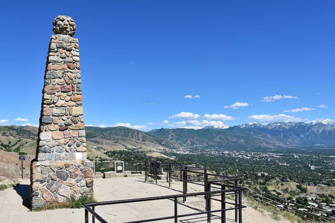
AllTrails sums up the payoff as views of the entire Salt Lake Valley, the Great Salt Lake and the surrounding mountain ranges.
If a mile is too short, AllTrails lists a 1.7-mile Ensign Peak Loop with about 370 feet of climbing, and a longer 6-mile route via Hell Canyon with about 940 feet for anyone who wants to keep going into the foothills.
The history at the top
Interpretive signs at the trailhead and summit tell the story, and it is the reason many Latter-day Saint families make this walk on purpose.
- July 26, 1847. Two days after the first pioneer company arrived in the valley, Brigham Young and a small group of leaders climbed the peak to look over the valley. The Ensign Peak Foundation names eight companions: Heber C. Kimball, Wilford Woodruff, George A. Smith, Ezra T. Benson, Willard Richards, Albert Carrington, William Clayton and Lorenzo D. Young.
- The name. Woodruff wrote that the group "considered A good place to raise An ensign," a banner or flag, and the name stuck.
- The monument, 1934. Young people of the Ensign Stake's Mutual Improvement Associations built the stone monument with the Utah Pioneer Trails and Landmarks Association. The foundation says it was dedicated on July 26, 1934, by President Heber J. Grant, and that its stones came from pioneer trail and historic sites, including the Nauvoo Temple site.
- The park. Salt Lake City owns the land. The Ensign Peak Foundation, organized in 1989, developed the 66-acre park with the city using private donations and still funds its maintenance, often through Eagle Scout projects.
Timing
AllTrails lists the trail as open year-round. Summer midday is hot on the open slope, so mornings and evenings are better. The view west makes it a sunset walk for many people; carry a light for the descent. In winter the steep section can ice up after storms, and inexpensive traction devices make the difference.
City Creek Canyon
A paved canyon road, as far as you like · walk any day, 8:30 a.m. to 10 p.m.
City Creek Canyon opens on the edge of downtown, and Salt Lake City runs it as part of its protected watershed with rules that favor walkers. From the city's City Creek Canyon brochure:
- Hours: 8:30 a.m. to 10 p.m. year-round; on holidays the canyon closes at 8 p.m., with no cars admitted after 6:30 p.m.
- Cars: in the summer season, which runs from Memorial Day weekend through September 30, cars are allowed only on even-numbered days and holidays, with a fee.
- Bicycles: on odd-numbered days in summer, except holidays; in winter unless posted. Bikes are not allowed on the canyon's trails except the Bonneville Shoreline Trail, and the road's speed limit for bikes is 15 mph.
- Dogs: leashed (6 feet maximum) below the water treatment plant at picnic area 16, and not above it. City Creek is one of Salt Lake City's four protected watershed canyons, so the dog rules are stricter here than in the foothills.
For a family that wants a walk without a steep climb, the canyon road is the answer: pavement beside the creek, picnic sites along the way, and the option to turn around whenever you like. It is the only one of these three walks on pavement, so it is the one to try with a stroller.
The Living Room
2.4 miles round trip · about 990 feet · leashed dogs allowed
In the Red Butte Canyon foothills on the city's east bench, the Living Room Lookout Trail climbs to a viewpoint where, as Hiking Project describes it, hikers have arranged large flat sandstone slabs into chairs and couches, armrests and ottomans included. AllTrails measures it at 2.4 miles round trip with about 990 feet of climbing, rated moderate, in the Foothills Natural Area. A 2.9-mile loop variant adds a little. Google Maps lists the trailhead at 383 Colorow Road. Hiking Project warns of narrow, rutted sections near the start, rocky footing and several nearby trails that are easy to confuse, so check your map at junctions.
It is the steepest of the three per mile and nearly treeless, so early morning or evening is the time, and it is a better fit for teens and adults than small children. From Temple Square the trailhead is about 5 miles and 12 minutes east by car.
Choosing one
| If you have | Do |
|---|---|
| 45 minutes and want a view and a story | Ensign Peak |
| A stroller or a grandparent who prefers flat ground | City Creek Canyon road |
| 90 minutes and want a workout | The Living Room |
| A dog | Ensign Peak or the Living Room, leashed |
Fitting it into a Salt Lake day from Provo
From downtown Provo, OpenStreetMap routing puts Temple Square about 54 minutes away and the Ensign Peak trailhead about 60 minutes, both via I-15. FrontRunner is the other way to reach downtown Salt Lake; our FrontRunner from Provo guide and Salt Lake City day trip cover that option. Ensign Peak is easiest by car, because the trailhead sits high in the Avenues.
About the Salt Lake Temple. The temple is closed for its multi-year renovation. The Church has announced a public open house from April to October 2027; our open house guide has the details as they firm up. For what you can see on the square in the meantime, read our Temple Square visitors' center guide.
Dressed for the temple? None of these is a walk for church shoes. Keep sneakers in the car. If you are in Salt Lake for a sealing or wedding, our temple wedding logistics guide covers the rest of the day.
If the short walks leave you wanting a real Salt Lake summit, see Mount Olympus and Grandeur Peak, about 27 to 31 minutes south of Ensign Peak by car.
Related Guides
- Things to do in Salt Lake City from Provo
- The Temple Square visitors' center
- The 2027 Salt Lake Temple open house
- Temple Square at Christmas from Provo
- Mount Olympus, Grandeur Peak and the Millcreek front
- General Conference weekend from Utah Valley
Frequently Asked Questions
How long is the Ensign Peak hike?
Where do you park for Ensign Peak?
Why is Ensign Peak important in Latter-day Saint history?
Can you bring a dog on Ensign Peak?
Can you walk up City Creek Canyon from downtown?
Is Ensign Peak good for sunset?
Is the Salt Lake Temple open?
How long does it take to get from Provo to Ensign Peak?
Sources
The facts in this guide were checked against these sources. Hours, fees and rules change, so confirm anything time-sensitive with the source before you go. How we make Provo.com.
- City Creek Canyon brochure (2023), Salt Lake City Public Utilities. Checked October 20, 2026.
- Dogs and the Wasatch Front Watershed (brochure, 2023), Salt Lake City Public Utilities. Checked October 20, 2026.
- Ensign Peak Park, Ensign Peak Foundation. Checked October 20, 2026.
- Salt Lake Temple open house celebration dates, Newsroom, The Church of Jesus Christ of Latter-day Saints. Checked October 20, 2026.
- Ensign Peak Trail and Overlook (and loop, Hell Canyon variants), AllTrails. Checked October 20, 2026.
- Living Room Lookout Trail, AllTrails. Checked October 20, 2026.
- The Living Room, Hiking Project. Checked October 20, 2026.
- OSRM routing API (OpenStreetMap data), drive times from Center St & University Ave, Provo, Project OSRM / OpenStreetMap contributors. Checked October 20, 2026.
- Google Maps place data (trailhead addresses and coordinates), Google Maps Platform (Places). Checked October 20, 2026.