
These two outings sit on the same mountain front and answer the same question: you have climbed to the Y, and you want the next step. Big Baldy is the hard answer, a bare 8,700-foot shoulder of Mount Timpanogos above Lindon and Pleasant Grove that takes most of a day. The Y-to-Rock-Canyon traverse is the gentle one, a 2.5-mile stretch of the Bonneville Shoreline Trail that links Provo's two busiest trailheads along the old lake bench. One builds legs for Timpanogos. The other is the walk you can do after class.
Trail figures below come from AllTrails and Hiking Project, which measure the same routes slightly differently; we give both where they disagree. Trailhead directions and trail rules come from the Uinta-Wasatch-Cache National Forest and Provo City.
Big Baldy at a glance
| From Dry Canyon (Lindon) | From Battle Creek (Pleasant Grove) | |
|---|---|---|
| Round trip | 7.2 mi (AllTrails); 7.5 mi (Hiking Project) | 9.9 mi (AllTrails) |
| Climbing | about 3,320 ft | about 3,520 ft |
| Top of the route | about 8,730 to 8,760 ft | same summit |
| Typical time | 5 to 7 hours | 6.5 to 7.5 hours |
Both are out-and-back routes rated hard. AllTrails also lists a 6-mile loop that climbs Dry Canyon and returns another way, and longer loops that link Dry Canyon, Battle Creek and the Bonneville Shoreline Trail at 10 to 11 miles.
Where Big Baldy is, and why it looks the way it does
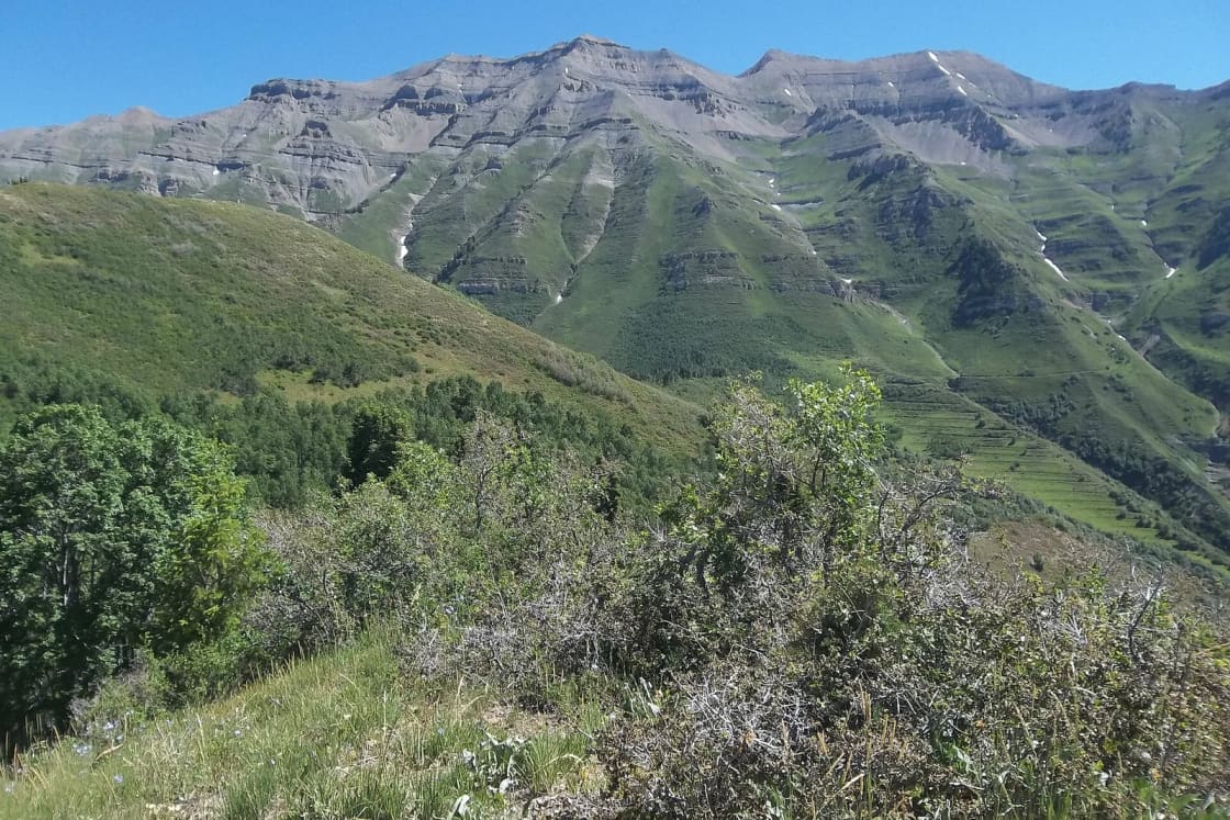
Big Baldy is the bare, rounded summit on the south end of the Timpanogos massif, above Lindon and Pleasant Grove. Dry Canyon climbs toward it from Lindon, and Battle Creek, with its waterfall, comes up from Pleasant Grove to the north.
The Forest Service trail that carries most hikers up is Dry Canyon Trail #049. Its official description is useful because it explains the shape of the day:
- The trail climbs through cliff bands at the start, then opens into meadows and oak brush.
- At 0.6 miles it passes the junction with Curly Springs Trail #051.
- 1.9 miles farther it reaches the junction with Little Baldy Trail #033.
- About a quarter mile beyond that is the saddle of Big Baldy, with views over northern Utah County.
- From the Little Baldy junction the trail turns north and runs 2.2 miles to Battle Creek Trail #050, then 0.8 miles more to Timpooneke Road.
So the saddle is about 2.75 miles up, and the summit is the climb from the saddle onto the bald top. Hiking Project's route notes describe the trail continuing straight along the ridgeline toward Timpooneke Road, with a left turn at a rock fire ring for Big Baldy. Expect many unsigned side paths in the meadows; the Hiking Project description of #049 says to stay on the trail just above the dry creek bed.
Near the saddle you pass long rows of stone and earth terraces cut across the slope. Hiking Project credits them to the Civilian Conservation Corps in the 1930s, built to hold snowmelt and stop erosion on the overgrazed front. They are the reason the route switches to loose, rocky footing in its upper third.
What makes it hard
The grade. The Forest Service rates Dry Canyon #049 at 10 to 25 percent grades. Hiking Project's track averages 17 percent for the whole summit route, with short pitches far steeper.
Narrow tread on cliff bands. The Forest Service's own caution for #049: the trail "runs along cliff bands and is very narrow," and it sees heavy use by hikers, horses and mountain bikers on any day. Step aside on the uphill side for riders and stock.
Loose rock on the way down. AllTrails' description and its review summary both single out steep, loose gravel on the descent. Trekking poles and shoes with real tread are the two pieces of gear that change this hike the most.
Sun and water. About half the route is open to the sun, and Hiking Project suggests one to two liters for the summit in summer. The Forest Service lists no potable water at the trailhead. The canyon's creek runs in wet years and not in dry ones; do not plan around it.
The bald top is exposed to weather. Above the trees there is nothing between you and an afternoon storm. The usual Wasatch rule applies: be heading down before clouds build.
The Battle Creek approach
The longer way up starts at the Battle Creek trailhead at Kiwanis Park in Pleasant Grove, passes Battle Creek Falls in the first mile, and keeps climbing to meet the Dry Canyon trail north of the Big Baldy saddle. AllTrails logs it at 9.9 miles round trip and about 3,520 feet, and describes it as "relentlessly uphill." It sees far fewer people than Dry Canyon above the falls, and AllTrails reviewers report overgrown sections and stinging plants, so long pants help.
If you can arrange a ride, going up Battle Creek and down Dry Canyon (or the reverse) turns the two into a point-to-point day. The two trailheads are about 4.3 miles and 12 minutes apart by car, by OpenStreetMap routing.
Big Baldy in late October and winter
It is late October as this is written. Three things apply now:
- Snow and ice on the upper third. Fall storms can whiten the summit while the lower canyon is still dry. Loose rock under a skin of snow is the worst footing this route offers. Microspikes and poles, or a turnaround at the saddle, are the sensible choices until spring.
- Short days. Five to seven hours on the trail means a start by mid-morning at the latest in November, and a headlamp in the pack regardless.
- Hunting season. This is national forest land, and fall is when hunters are out on it. Wear something bright. Our guide to hunting near Provo explains how the seasons fall.
AllTrails lists April through October as the best months. The lower stretch of Dry Canyon, below the Curly Springs junction at 0.6 miles, is a short workout in any season when the top is out of condition.
Who Big Baldy suits
Big Baldy is a training hike for Mount Timpanogos on the same mountain. If you can reach the Big Baldy summit and come down the loose slope comfortably, you have a fair read on how you will handle a much longer Timp day. If the climb to the saddle leaves you spent, the saddle is a fine destination on its own: the views over northern Utah County start there.
For a summit of similar effort with a road doing some of the work, see Buffalo Peak off the Squaw Peak Road. For a quieter long traverse at the same height along the Timpanogos front, Little Baldy Trail #033 leaves from the junction at mile 2.5 and runs 4.4 miles south to meet the Bonneville Shoreline Trail. The Forest Service lists it as hiker and horse only.
The Y-to-Rock-Canyon traverse
| Y Mountain Trailhead to Rock Canyon | |
|---|---|
| Distance | about 2.5 mi one way; AllTrails lists 5.1 mi out-and-back |
| Climbing | about 650 ft for the out-and-back |
| High point | about 5,300 ft |
| Footing | packed dirt and gravel, open bench |
| Dogs | allowed (Provo City) |
This is one of the original segments of the Bonneville Shoreline Trail. AllTrails notes it was designated by Provo City in the early 2000s. It traces the bench above the east side of BYU campus and the neighborhoods north of it, along the shoreline of prehistoric Lake Bonneville, between the Y Mountain trailhead and the Rock Canyon trailhead.
Why it is worth doing
Most people on these two trailheads are going up: switchbacks to the Y, or into the walls of Rock Canyon. The bench between them goes across. You get the views of Utah Valley, Utah Lake and the west mountains that the Y climb earns, with a fraction of the effort, and you can do it in about an hour each way at a walking pace (AllTrails puts the out-and-back at two to two and a half hours).
It is also the most useful trail on this side of Provo for a run. The grade is rolling rather than steep, and the open bench drains faster after rain than the canyon floors.
Where to start
- Y Mountain Trailhead. Provo City maintains the trailhead; BYU maintains the trail to the Y; the Forest Service maintains it beyond the letter. The lot is small and fills early on weekends.
- Rock Canyon Trailhead. Provo City's trails page gives the address as the end of North Temple Drive, directly east of the Provo Utah Temple. Many maps use an East 2300 North address for the same lot. Do not confuse it with the Park at Rock Canyon, the grassy hill a short way south; our Rock Canyon guide explains the two-parks mix-up and what the rebuilt trailhead offers, including year-round restrooms.
Rock Canyon is the easier place to park and has the better facilities, so many people start there and walk south to the Y.
Making it a loop
The two trailheads are only about 1.4 miles apart by street (OpenStreetMap routing), so you can walk the bench one way and return through the neighborhoods below for a loop of roughly four miles without a second car. The street return is all residential sidewalk and road; keep to public streets and be considerate of the people who live there.
The gate at the north end
AllTrails' description makes a point worth repeating: the official trail ends at a gate just north of Rock Canyon, and an open route continues across private property for about another half mile. That stretch stays open at the owners' discretion. Stay on the path, do not cut new lines, and turn around where signs ask you to.
In late fall and winter
The bench is the trail to choose when the canyons are icy. It sits low on the open bench, close to the valley, so it sheds snow sooner than the canyons. Shaded spots can stay icy after a storm, and traction devices are cheap insurance in January. Our Bonneville Shoreline guide covers the winter rule that catches people out on the longer segments.
Etiquette
This segment is shared by hikers, runners, mountain bikers and dog walkers. Bikes yield to walkers, everyone yields to horses, and downhill traffic gives way to uphill. Pick up after your dog; the trail runs right above backyards.
Choosing between them
| If you want | Pick |
|---|---|
| A summit and a full day | Big Baldy from Dry Canyon |
| A Timpanogos training hike | Big Baldy |
| An hour or two, any season | Y to Rock Canyon |
| Valley views with almost no climbing | Y to Rock Canyon |
| Fewest people | Big Baldy via Battle Creek, above the falls |
Both routes are in our full index of Provo hikes, alongside the other trails that start from the same bench.
Related Guides
- Hiking Mount Timpanogos
- Battle Creek Falls
- Lesser-known hikes near Provo
- The Bonneville Shoreline Trail in Provo and Orem
- The Y Mountain Trail
- The Rock Canyon Trail
- Dog-friendly hikes near Provo
Frequently Asked Questions
How long is the Big Baldy hike?
Where does the Big Baldy trail start?
Is Big Baldy harder than the Y?
How far is it from the Y trailhead to Rock Canyon?
Can you bring a dog on these trails?
Is there a fee to park?
Can you hike Big Baldy in winter?
How long does it take to drive from Provo to these trailheads?
Sources
The facts in this guide were checked against these sources. Hours, fees and rules change, so confirm anything time-sensitive with the source before you go. How we make Provo.com.
- Dry Canyon Trail #049, USDA Forest Service, Uinta-Wasatch-Cache NF. Checked October 20, 2026.
- Little Baldy Trail #033, USDA Forest Service, Uinta-Wasatch-Cache NF. Checked October 20, 2026.
- Provo City: Trails, Provo City. Checked October 20, 2026.
- Big Baldy Summit, AllTrails. Checked October 20, 2026.
- Big Baldy via Battle Creek, AllTrails. Checked October 20, 2026.
- Big Baldy Summit via Dry Canyon Trail Loop (and related loops), AllTrails. Checked October 20, 2026.
- Big Baldy via Dry Canyon, Hiking Project. Checked October 20, 2026.
- GWT: Dry Canyon Trail #049, Hiking Project. Checked October 20, 2026.
- Bonneville Shoreline Trail: Y Mountain-Rock Canyon, AllTrails. Checked October 20, 2026.
- OSRM routing API (OpenStreetMap data), drive times from Center St & University Ave, Provo, Project OSRM / OpenStreetMap contributors. Checked October 20, 2026.