Most people who live in Utah Valley know the names Timpanogos and Utah Lake. Far fewer know that farmers were digging irrigation ditches, storing corn and living in pithouses along these same mountain streams long before any of those names were written down. Archaeologists call those farmers the Fremont. This guide explains what is known about them, where the evidence is thinnest and where it is richest, and which sites are worth the drive from Provo.
It is a companion to our guide to the Timpanogos people of Utah Valley, which covers the Native people recorded here in the historic period. The Fremont belong to an earlier chapter, and the two should not be confused or collapsed into each other.
Quick facts
| Topic | What to know | Source or check |
|---|---|---|
| Name | Archaeologists named the culture for the Fremont River canyon in Utah | National Park Service, Capitol Reef |
| Dates | Sources vary: about 300 to 1300 CE (NPS), or about 500 BC to 1250 AD for the whole period (Utah Historical Society) | Compare both pages |
| Region | Central and northern Utah, in the Great Basin | Utah Historical Society |
| Food | Corn, beans and squash, plus hunting, fishing and gathering | Utah Historical Society |
| Homes | Partly underground pithouses, sometimes in villages with storage buildings | Utah Historical Society |
| Best rock art day trips | Nine Mile Canyon, Capitol Reef (Highway 24 panels), Dinosaur National Monument | Official pages below |
| Dedicated museum | Fremont Indian State Park, Sevier, exhibits closed for renovation until a planned November 21 reopening | stateparks.utah.gov |
| Rule that matters most | Look, photograph, do not touch, do not collect | Archaeological Resources Protection Act, 1979 |
Who the Fremont were
The Utah Historical Society's Fremont Period page places the Fremont in central and northern Utah, in the Great Basin. South of them, in southern Utah and the Four Corners states, lived Ancestral Puebloan people on the Colorado Plateau. The two are separate archaeological cultures, though they shared a regional pattern of farming.
Farming itself arrived from the south. The Historical Society says corn, beans and squash came to Utah from people in present-day Arizona and New Mexico, and that Fremont communities grew them to supplement their diets. Hunting and gathering stayed important for meat and wild plants. What changed was how long people stayed put. Tending crops meant staying in one place longer, so Fremont people were less mobile than the earlier Archaic and Paleoindian peoples.
They built pithouses, partially underground homes that helped regulate temperature, and some lived in villages of clustered pithouses and storage units. The Historical Society also notes real variety. Some communities relied mainly on hunting, gathering and fishing. Others, near the Great Salt Lake and Utah Lake, depended more on farming. Archaeologists think culture and language varied widely across the period, which is a good reason to treat "the Fremont" as a convenient label rather than one unified nation.
That last point matters for how you read signs and museum labels. "Fremont" was assigned by researchers. The National Park Service says the name comes from the Fremont River canyon where the culture was first identified, which is why the same word turns up on a river, a state park and a lot of museum cases.
The dates, and why sources disagree
If you read several official pages you will see different numbers, and none of them is wrong in an obvious way.
- The Utah Historical Society's Fremont Period page is headed "c. 500 BC to 1250 AD." That range covers the arrival of farming in the Great Basin through the end of the Fremont way of life.
- The Historical Society's Utah County page says Fremont people lived in the area until about 1200 AD.
- The National Park Service's Capitol Reef page says the Fremont lived in present-day Utah from about 300 to 1300 CE.
Archaeological cultures are defined by what researchers choose to count: pottery, house forms, rock art style, farming. Different definitions give different start and end dates. When a sign at a site gives a range, use that site's range and treat it as an approximation.
Utah Valley and Utah Lake
The Historical Society says large Fremont communities lived where Salt Lake City and Provo are today, using mountain rivers and Utah Lake and building irrigation systems to water their crops. Its Utah County page adds that the lake was once a rich fishery where people lived and camped on the shore, and that Fremont people in the area farmed corn, squash and beans while also fishing, hunting and gathering.
The local picture is that the Fremont story here is mostly under the pavement. Fremont-era villages and fields sat on the same fertile, well-watered ground that later became Provo, Orem, Springville and Spanish Fork, and modern development has covered most of it. There is no Utah Valley equivalent of a signed pithouse village open to the public that we could confirm from official sources today. If a city park, trail or museum here advertises Fremont material, check the managing agency's page for what is on display and whether the site is open.
For how the lake itself fits into the longer human story, see our Utah Lake history and the account of the 1776 Dominguez-Escalante expedition, which recorded the valley's people at the moment Europeans first wrote about them. For a Provo-based look at the museum side, the BYU Museum of Peoples and Cultures is the closest option, and its exhibits and hours change, so check its site first.
What happened around 1250
The Historical Society's account is brief and careful. A drought of about 50 years around 1250 AD made farming difficult. People went back to hunting and gathering and began moving across the landscape again. Some migrated north or west, others changed their lifestyles, and new Native groups, such as the Navajo (Dine), began moving into Utah. Some archaeologists think Fremont people may have joined these newcomers and helped form new Indigenous cultures. The Society's page presents this as what some archaeologists think, not as settled fact, and it includes no statements from tribal nations.
At Capitol Reef, the National Park Service shares a narration by Rick Pickyavit, identified as a Southern Paiute narrator. He describes the Fremont as farmers and hunter-gatherers who stayed in one place rather than moving with the seasons, says their origins and their reasons for leaving in the 13th century are largely unknown, and notes that Ute and Southern Paiute peoples later lived in the region. He also cautions that the meaning of the petroglyphs is uncertain. Dinosaur National Monument's page says many of its petroglyphs and pictographs are attributed to Fremont peoples "whose descendants still live in the area."
Those are the connections the sources we read state. We are not going to claim more than that about which modern nations descend from the Fremont, and visitors should not either. If a site asks you to learn from a tribal perspective, take the time to read or listen to it.
Where to see Fremont sites
Nine Mile Canyon (Carbon and Duchesne counties)
Nine Mile Canyon is the most rewarding Fremont rock art trip you can make in a day from Provo. Our Nine Mile Canyon, Helper and Price guide covers the route: US-6 from Spanish Fork over Soldier Summit, through Helper and Price, then northeast near Wellington into the canyon. Fuel up and buy food and water in Price or Wellington, because the canyon itself is remote.
The National Park Service's listing for the Great Hunt Panel Site describes it as lying along Nine Mile Canyon Road about 45 miles north and east of Wellington, at the mouth of Cottonwood Canyon. The site is on the National Register of Historic Places and has five prehistoric rock art panels. The best known, the Great Hunt Panel, shows at least 30 bighorn sheep and eight human figures in a pattern interpreted as a communal hunt. The motifs span the Archaic through Fremont periods. The page says impacts to the panel appear minimal, mainly natural erosion and road dust. It does not say who manages the land, so check current access information before you go, and treat any gate, sign or fence as binding.
What to bring: a full tank, water, food, binoculars and a camera with a zoom lens. Cell coverage in the canyon should not be assumed. The NPS notes road dust at the Great Hunt Panel, and the canyon is long, so start early.
Capitol Reef National Park (Wayne County)
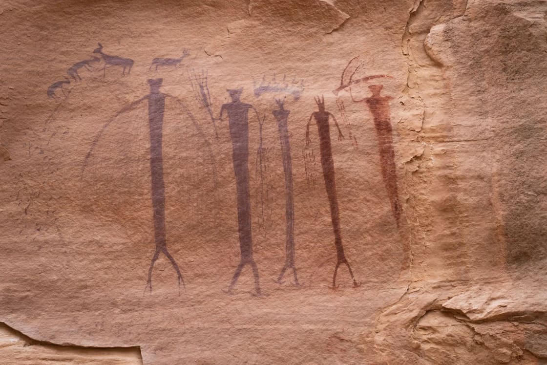
The Fremont petroglyph panels sit along Utah State Route 24 in the park, with two wooden boardwalks for viewing. According to the National Park Service, the shorter boardwalk shows large human-like figures, bighorn sheep, other animals and geometric designs. The longer boardwalk runs along the cliffs, and its petroglyphs are closer but harder to see because a patina has formed over them. Visibility varies with the time of day and the panel, binoculars help, and the more time you spend looking, the more figures you notice. Three wayside panels are titled "Signs of a Thriving People," "Stories in Stone" and "If Cliffs Could Speak."
The NPS page lists these rules: do not touch the petroglyphs, all archeological sites are protected under the Archaeological Resources Protection Act of 1979, and vandalism is a federal crime punishable by up to one year in prison and a fine of up to $20,000. To report vandalism or suspicious activity, tell the visitor center or a park employee, or call the park tip line at (435) 425-4134. The park phone is 435-425-3791.
From Provo it is a long drive. Our Capitol Reef guide puts it at about 180 miles to the Fruita visitor center, via US-89 through the Sanpete Valley, and notes that Hickman Bridge has Fremont granary ruins visible along the trail. Fees and seasonal hours change, so check the park's page for entrance and visitor center details.
Fremont Indian State Park and Museum (Sevier, Sevier County)
This is the park built around Fremont archaeology. It is at 3820 Clear Creek Canyon Rd in Sevier. The state parks page says the park protects petroglyphs and pictographs left by the Fremont culture, and that the museum displays objects from the largest known Fremont village site, uncovered during Interstate 70 construction, including pottery, baskets and arrowheads. The park is also a designated International Dark Sky Park.
Current status, as of the page we read on November 7, 2026: the museum exhibits are closed for renovations, with a Grand Re-Opening Celebration listed for Saturday, November 21, from 11 a.m. to 3 p.m. The visitor center, gift shop, art gallery and outdoor areas are listed as open. Hours are 9 a.m. to 5 p.m., Sunday through Saturday in summer (March to September) and Monday through Saturday in winter (October to March), and the park is closed for Thanksgiving, Christmas Eve and Christmas Day. The phone number is 435-527-4631.
The page does not list fee amounts, and it points to separate Park Fees, Current Conditions and Rules and FAQs pages. Read those before you go. Nearby camping includes Castle Rock and Sam Stowe campgrounds, and the park lists cabins, a teepee, and RV and primitive sites. The listed Thanksgiving closure and the museum renovation both argue for calling ahead if you are going this month.
Dinosaur National Monument (Utah and Colorado)
Dinosaur is better known for fossils, and our Uinta Basin and Dinosaur Country loop covers the drive. The National Park Service's history page says people have lived in the area for at least 10,000 years, and that many of the monument's petroglyphs and pictographs are attributed to Fremont peoples. At McKee Spring, several petroglyph panels decorate the rockfaces, and one central figure appears to hold a bell-shaped object and a circular shield or sun. The page links to a separate guide on viewing rock art, which is the page to read before you go.
Natural History Museum of Utah (Salt Lake City)
Not every Fremont encounter needs a long drive. The museum, at 301 Wakara Way in Salt Lake City, is open 10 a.m. to 5 p.m. daily, until 9 p.m. on Wednesdays, with last admission 30 minutes before closing. Its visit page lists two permanent exhibitions relevant here: First Peoples, with archaeological artifacts from Utah's earliest people, and Native Voices. The page does not mention the Fremont by name and lists no ticket prices, so check the exhibit pages and the ticketing link. Phone: 801-581-6927.
How to visit respectfully
Rock art and village remains are among the few direct records of people who left no writing, and they cannot be replaced.
- Do not touch. The park service says so directly at Capitol Reef. The oils on skin can harm rock surfaces, a point other guides repeat.
- Do not collect. Pottery sherds, flakes and arrowheads on public land belong to the public record. The National Park Service says the Archaeological Resources Protection Act, signed October 31, 1979 (Public Law 96-95, 16 U.S.C. 470aa through 470mm), protects archeological resources on public and Indian lands. It sets criminal penalties for unpermitted activity. Excavating or trafficking can bring up to two years in prison and a fine of up to $20,000. Injury or depredation to United States property can bring up to ten years and a fine of up to $250,000. Equipment used in the crime, including metal detectors and vehicles, can be confiscated.
- Know the older law too. The 1906 Antiquities Act set up permits and penalties for unauthorized removal of objects and destruction of sites, but the NPS notes it did not effectively deter looting, which is why Congress passed ARPA.
- Utah has its own rules for state land. Utah's antiquities provisions fall under the Division of State History. We could not pull the current statute text today, so check the division's website for what applies to state lands.
- Stay on trails and boardwalks. Do not lean on walls, chalk or trace images, or climb on ruins.
- Report, do not repair. If you see damage, tell the land manager. At Capitol Reef that is the visitor center or the tip line above.
- Interpret with humility. The Capitol Reef narrator says the meaning of the petroglyphs is uncertain. Treat any confident label, ours included, as a best current reading.
Choosing a trip from Provo
| If you want | Go to | Plan on |
|---|---|---|
| The best rock art in a day trip | Nine Mile Canyon | A full day, fuel and water from Price or Wellington |
| Easy viewing, boardwalks, a stop on a larger trip | Capitol Reef, Highway 24 panels | About 180 miles each way, usually an overnight |
| A museum devoted to the Fremont | Fremont Indian State Park, Sevier | Call first, exhibits closed until the planned reopening |
| Rock art plus fossils | Dinosaur National Monument | A multi-day Uinta Basin trip |
| An indoor look with no long drive | Natural History Museum of Utah, or BYU Museum of Peoples and Cultures | Check exhibits and hours |
More ideas for long drives are in our day trips from Provo guide.
Who should skip it
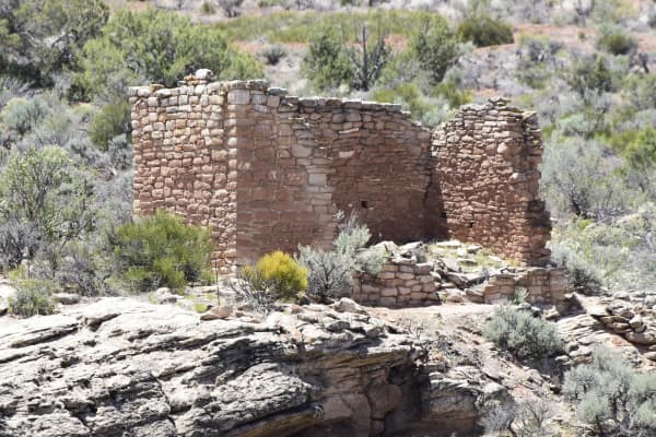
Anyone expecting cliff dwellings will be disappointed. Fremont sites are mostly rock art, granaries and low ruins, and much of the story is told by signs and museum cases. Nine Mile Canyon is a long, remote drive, which is a lot to ask of impatient kids. Winter can close or complicate remote roads, so check conditions. If you cannot commit to staying behind the line and leaving objects alone, do not go.
Before you go
- Confirm hours and fees on the official page the week you leave. Everything in this article about Fremont Indian State Park was read on November 7, 2026, and the museum situation could change.
- Download maps offline. Coverage in Nine Mile Canyon and parts of Wayne and Sevier counties is unreliable.
- Bring binoculars. The NPS recommends them at Capitol Reef, and they help at every panel.
- Carry water, snacks, a full tank and sun protection.
- Read each site's wayside panels, which often carry the most current archaeological interpretation.
Frequently Asked Questions
Who were the Fremont people?
When did the Fremont live in Utah?
Did the Fremont live in Utah Valley?
What happened to the Fremont?
Where is the nearest place to see Fremont rock art from Provo?
Can I touch petroglyphs or take pottery sherds and arrowheads?
Is the Fremont Indian State Park museum open?
Are there Fremont exhibits in Salt Lake City or Provo?
Sources
The facts in this guide were checked against these sources. Hours, fees and rules change, so confirm anything time-sensitive with the source before you go. How we make Provo.com.
- The Fremont Period, Utah Division of State History (I Love History). Checked November 7, 2026.
- Utah Division of State History (I Love History): Utah County, Utah Division of State History (I Love History). Checked November 7, 2026.
- Fremont Indian State Park and Museum, Utah State Parks. Checked November 7, 2026.
- Fremont Culture Petroglyphs, National Park Service, Capitol Reef National Park. Checked November 7, 2026.
- Archaeological Resources Protection Act of 1979, National Park Service. Checked November 7, 2026.
- Great Hunt Panel Site, National Park Service. Checked November 7, 2026.
- History and Culture, Dinosaur National Monument, National Park Service. Checked November 7, 2026.
- Plan Your Visit, Natural History Museum of Utah. Checked November 7, 2026.