
East of Utah Valley, past the mountains that frame the eastern skyline, the land changes character entirely. US-6 climbs out of Spanish Fork Canyon, crosses the divide at Soldier Summit and drops down Price Canyon into a country of sandstone cliffs, coal towns and wide desert sky. Within a couple of hours of Provo you can stand on the Main Street of a railroad town that once served a ring of coal camps, walk through a museum built around a dinosaur skeleton, and then spend an afternoon in a canyon where the rock walls are covered with images pecked and painted by people who lived there centuries before any of the towns existed.
This guide covers that day: the drive, the railroad town of Helper, the Prehistoric Museum in Price, and Nine Mile Canyon, which the Bureau of Land Management says is often described as the world's longest art gallery. It also covers the practical side, because Nine Mile Canyon is remote, has no services, and runs through private ranchland as well as public land. Helper is also an Amtrak stop; see our train days guide.
The Short Answer
Leave Provo early and drive US-6 from Spanish Fork over Soldier Summit to Helper, where the historic Main Street and the Western Mining and Railroad Museum are worth an hour. Continue to Price for the Prehistoric Museum, and fuel up and buy food and water there or in Wellington. From Wellington, head northeast on Soldier Creek Road into Nine Mile Canyon, which the BLM describes as 46 miles long, with rock-art panels, a picnic area and restrooms at Cottonwood Glen, restrooms and parking at Daddy Canyon, and trailheads to rock-art sites and a Fremont village in Cottonwood Canyon. There is no fee. Respect private property, never touch the rock art, and allow a full day.
The Drive: Spanish Fork Canyon and Soldier Summit
The trip starts in the valley's own backyard. From Spanish Fork, US-6 heads up Spanish Fork Canyon, past Diamond Fork and the site of the town of Thistle, which a landslide dammed and flooded in the early 1980s. Our guide to Spanish Fork Canyon covers the stops along the way, and our history of the Thistle landslide tells the story of the town that drowned. If you have time on the way back, either makes a good break.
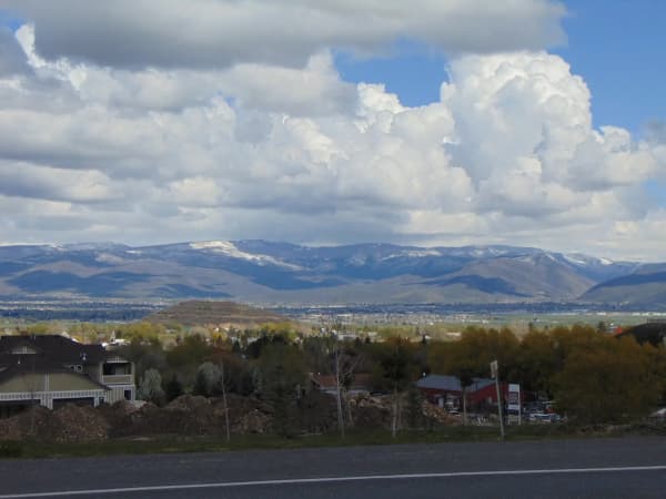
Beyond the canyon, the highway climbs to Soldier Summit, the divide between the Great Basin and the Colorado River drainage, and then descends through Price Canyon toward Helper. The road is a major freight route, busy with trucks, and it can be icy in winter, so check conditions before an off-season trip and allow extra time.
The descent into Price Canyon is also where the scenery changes. The cliffs turn tan and gray, the vegetation thins, and the Book Cliffs, a long escarpment that runs east across the region, rise above the towns.
Helper: The Town Named for a Locomotive
Helper sits at the mouth of Price Canyon, beside the Price River, and its name tells its history. The city explains that it is named for the extra engines that were once required to help trains up the steep grade to Soldier Summit. The railroad made the town, and the coal mines of the surrounding canyons made it busy: Helper became a central hub for many coal-mining camps, most of which have since vanished into the canyons around it.
That history drew workers from many countries, and the town's cultural mix is part of its identity to this day. When the coal and railroad economy faded, Helper came close to emptying out. In recent decades it has reinvented itself, with galleries, murals, cafés and shops filling the old storefronts on Main Street.
The historic district. The center of town is listed on the National Register of Historic Places as the Helper Historic District, originally listed as the Helper Commercial District. Its buildings are mostly one and two stories, many of red brick, and the district includes modest company-built houses as well as the commercial blocks. A walk down Main Street is the heart of any visit.
The Western Mining and Railroad Museum. The town's museum occupies the old Helper Hotel building on Main Street and tells the story of the mines, the railroad and the people who worked them, with tools and equipment used underground and on the rails. It is the best way to understand what you are looking at in the rest of the town. Check the museum's current days and hours before you plan around it, since small-town museums keep limited schedules.
Getting there by train. Amtrak's California Zephyr stops in Helper, which makes a rail trip to the town possible in principle, though the train runs once a day in each direction and the schedule rarely suits a same-day return. Our guide to riding the Zephyr from Provo explains how the train works.
Price: The Prehistoric Museum
A few miles past Helper, Price is the Carbon County seat and the largest town in the area, with the restaurants, grocery stores and fuel stations you will want before heading into Nine Mile Canyon. The quarry many of these bones came from is south of Price; see our Jurassic National Monument guide.
It is also home to the Prehistoric Museum of Utah State University Eastern, on Main Street. The museum's own history is a good story. It began as a civic project, when local leaders set out to acquire and display an Allosaurus skeleton to draw visitors, and it grew into an accredited museum that serves as a state and federal repository for archaeological and paleontological collections, now part of Utah State University. Its exhibits span both halves of that mission, from dinosaurs to the cultures that made the region's rock art, which makes it the ideal introduction to Nine Mile Canyon. Our guide to dinosaur museums puts it alongside the fossil collections closer to home.
Check the museum's website for current hours and admission before you go.
Nine Mile Canyon: The World's Longest Art Gallery
The Bureau of Land Management, which manages much of the canyon, describes Nine Mile Canyon as 46 miles long and notes that it is often called the world's longest art gallery. The canyon's walls hold rock art along much of their length: petroglyphs pecked into the dark desert varnish of the sandstone, pictographs painted on the rock, and historic inscriptions left by later travelers and settlers. Most of the rock art is attributed to the Fremont, the farming and foraging people who lived across much of what is now Utah centuries ago, and later to the Ute.
The name is misleading, since the canyon is far longer than nine miles, and the BLM notes that the canyon offers much more than rock art: hiking, biking, exploring side canyons, picnicking, and seeing remnants of the prehistoric and historic uses of the canyon, as well as its current use by the ranchers who live there. The canyon bottom is flat and green, used for cattle grazing and farming, while the walls rise into craggy outcrops topped with pinyon, juniper and sagebrush.
Getting there. The BLM's directions start from Wellington, south of Price: head northeast along Soldier Creek Road, which leads into the canyon. The agency notes that a loop is possible by continuing through Gate Canyon to the town of Myton, west of Vernal, which makes the canyon a route to the Uinta Basin as well as a destination.
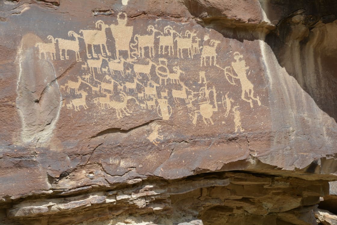
What you will find. The BLM lists several identified rock-art panels along the canyon; a picnic area, restrooms and a historic homestead at Cottonwood Glen; trailheads to rock-art panels, hiking, parking and restrooms at Daddy Canyon; and trailheads to rock-art sites and a Fremont village beyond Frank's Canyon in Cottonwood Canyon, a side canyon. The most famous single panel, the Great Hunt Panel, depicts a herd of bighorn sheep surrounded by hunters and a large horned figure, and the BLM calls it one of the most recognized and famous rock-art sites in Utah.
Fees. The BLM lists no fee.
A Little Background: Who Made the Art
The people most associated with Nine Mile Canyon's rock art are the Fremont, a culture that archaeologists define by its pottery, its pit houses and granaries, its farming of corn, beans and squash alongside hunting and gathering, and its distinctive art. Fremont petroglyphs often show broad-shouldered human figures, sometimes wearing headdresses or ornaments, along with bighorn sheep, deer, snakes and abstract designs. Later rock art in the region is attributed to the Ute, and some later panels include horses, which tells you they were made after horses reached the region.
Nobody can say for certain what each image meant. Archaeologists have proposed readings that range from hunting records and clan symbols to calendars and spiritual imagery, and descendant communities have their own understanding of these places. What is certain is that the canyon was a place people returned to over a very long time, and that its panels are a record of their lives. The granaries tucked into cliff ledges and the village site in Cottonwood Canyon are reminders that the art was made by people who lived and farmed here, not passersby.
How to See the Rock Art
The rock art is everywhere once you learn to look, and easy to miss at highway speed.
Drive slowly and use pullouts. Pull fully off the road to look, and never stop in the travel lane. The canyon road can carry ranch and industrial traffic, including heavy trucks, and the curves limit visibility.
Scan the dark patches. Petroglyphs show up best on the dark desert varnish of the sandstone, where pecking exposed lighter rock beneath. Look along the base of cliffs and on large boulders near the canyon floor.
Use binoculars. Many panels are high on the cliffs or across private fields, and binoculars let you see them clearly from the road or a signed site.
Chase the light. Morning and late-afternoon light rakes across the rock and makes petroglyphs stand out. Harsh midday sun flattens them.
Stop at the signed sites. Where the BLM has marked panels, parking and trails, you can get close safely and legally.
Private Land and Public Land
Much of the canyon bottom is private land, owned by ranching families whose predecessors settled there generations ago. The BLM's own page asks visitors to respect private property when exploring the side canyons. In practice, that means staying on the road and on public land and signed sites, closing any gate you open, not crossing fences, and not walking across fields to reach a panel. The canyon's residents live with a steady stream of visitors, and courtesy keeps access open for everyone.
Rock-Art Etiquette
The panels in Nine Mile Canyon have survived for centuries because they were left alone. A single careless visit can do damage that no one can repair.
Never touch the rock art. Oils from skin break down the rock surface and the varnish that makes petroglyphs visible.
No chalk, tracing, rubbing or wetting to make images stand out for photographs. Photograph what is there.
Do not climb on panels or the rocks around them, and keep children and pets back from the walls.
Leave everything where it is. Artifacts, pottery sherds and stone tools belong where they lie, where they still carry information for archaeologists. Federal law protects archaeological sites on public land.
Report vandalism to the BLM's Price Field Office.
Planning the Day
Start early. The drive to the canyon, the stops in Helper and Price, and the canyon itself add up to a long day, and you will want daylight in the canyon.
Fuel and supplies. There are no services in Nine Mile Canyon. Fill the tank and buy food and water in Price or Wellington.
Water, sun and layers. Bring more water than you expect to drink, sun protection and a jacket; the high desert changes temperature quickly.
Cell service. Expect it to be unreliable in the canyon. Download maps before you go, and tell someone your plans.
Vehicles. The main canyon road is suitable for ordinary passenger cars in good conditions. Side roads and the Gate Canyon route may be rougher, so check conditions with the BLM before attempting them, especially after rain or in winter.
Seasons. Spring and fall are best. Summer is hot and exposed, and winter can bring snow and ice.
A Suggested Itinerary
Morning. Leave Provo early and drive US-6 over Soldier Summit. Stop in Helper to walk Main Street and visit the Western Mining and Railroad Museum if it is open.
Late morning. Continue to Price for the Prehistoric Museum, then fuel up and pick up lunch and water.
Afternoon. Drive to Wellington and turn up Soldier Creek Road into Nine Mile Canyon. Picnic at Cottonwood Glen, use the restrooms at Daddy Canyon, and work your way to the rock-art sites in Cottonwood Canyon as the afternoon light improves.
Evening. Return the way you came, stopping for dinner in Price or Helper, and drive US-6 home carefully after dark, when wildlife and trucks share the road.
If you would rather not rush, spend the night in Price or Helper and take a second day for the canyon or the San Rafael Swell to the south.
Photographing the Panels
Rock art rewards a patient photographer. A moderate telephoto lens or the zoom on a phone lets you frame high panels from the road or a signed site, and a polarizing filter can cut glare on the varnished rock. Low-angle light in the morning and late afternoon brings out the texture of the pecking, while flat midday light can make even a famous panel look faint. Shoot from where the trail or pullout puts you rather than climbing for a better angle, and never add chalk, water or any other enhancement to make an image stand out.
Visiting With Children
Children often love Nine Mile Canyon, because the rock art feels like a treasure hunt. Give each child a pair of binoculars and a list of things to find, such as a bighorn sheep, a human figure, a spiral and a snake, and let them spot panels from the car. Explain the rules before you arrive: look with your eyes, not your hands, and stay off the rocks. Pack snacks, water and something to do on the long drive, and plan a picnic at Cottonwood Glen as the midday break.
If You Have More Time: The Uinta Basin Loop
The BLM notes that a loop is possible through Gate Canyon to Myton, west of Vernal. From Myton, US-40 leads west through Duchesne and over the high country past Strawberry Reservoir to Heber, and from Heber, US-189 runs down Provo Canyon to Provo, which closes the circle. It is a long day even without stops, and the Gate Canyon section is rougher than the main canyon road, so check conditions with the BLM first and save the loop for long summer days. Our guide to Strawberry Reservoir covers the big lake on the way home. Our Uinta Basin dinosaur country loop lays out the paved version.
Combining With Other Trips
Nine Mile Canyon and Helper fit neatly with other destinations southeast of the valley. Goblin Valley and the San Rafael Swell lie farther south, and our guide to them covers the drive. Spanish Fork Canyon itself, with Diamond Fork's hot springs trail and the Thistle site, is worth a separate day. And for a train-based adventure, the California Zephyr passes through Price Canyon and Helper on its way east.
The Short Version
Drive US-6 from Spanish Fork over Soldier Summit to Helper, the railroad town named for the helper engines that pushed trains up the grade, and walk its historic Main Street and mining and railroad museum. Continue to Price for USU Eastern's Prehistoric Museum and fuel, food and water. Then take Soldier Creek Road from Wellington into Nine Mile Canyon, which the BLM describes as 46 miles long and often called the world's longest art gallery, with no fee, facilities at Cottonwood Glen and Daddy Canyon, and rock-art trailheads and a Fremont village in Cottonwood Canyon. Stay on public land, never touch the rock art, watch the light, and give yourself the whole day.
Related Guides
- Spanish Fork Canyon: Diamond Fork, Sheep Creek and the Thistle Site
- The Thistle Landslide: The Town That Drowned
- Goblin Valley and the San Rafael Swell From Provo
- Dinosaur Museums in Utah Valley
- Riding the California Zephyr From Provo
- Day Trips From Provo
Frequently Asked Questions
How far is Nine Mile Canyon from Provo?
Why is Nine Mile Canyon called the world's longest art gallery?
Is there a fee to visit Nine Mile Canyon?
Are there restrooms or services in Nine Mile Canyon?
What is there to do in Helper?
What is the Prehistoric Museum in Price?
Can I touch the petroglyphs?
When is the best time to visit Nine Mile Canyon?
Sources
The facts in this guide were checked against these sources. Hours, fees and rules change, so confirm anything time-sensitive with the source before you go. How we make Provo.com.
- Bureau of Land Management: 9 Mile Canyon, Bureau of Land Management. Checked October 12, 2026.