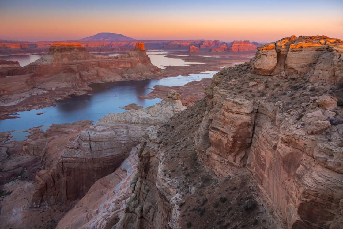
In the winter of 1879 to 1880, a company of roughly 250 Latter-day Saint settlers stood at the rim of Glen Canyon with about 80 wagons and a problem: the shortcut they had chosen to the San Juan River ran straight into a 1,000-foot-plus cliff above the Colorado. They did not turn back. They spent about six weeks blasting and chiseling a wagon road through a narrow crack in the rock, lowered the wagons down by rope and brake, ferried across the river, and kept going another 100-plus miles. They founded Bluff on April 6, 1880. The National Park Service says the trip was planned to take six weeks and took six months.
| Detail | What the sources say | Source |
|---|---|---|
| Call and purpose | San Juan Mission, called by Church President John Taylor | Utah State Historical Society; Ensign |
| Size of company | 236 to about 263 people, depending on the account | History Blazer; NPS; Utah Humanities |
| Wagons | About 80 to 83 | NPS; Ensign; Utah History Encyclopedia |
| Gathering point | Forty-Mile Spring, south of Escalante, November 1879 | NPS; History Blazer |
| Road work | About six weeks, December 1879 to January 1880 | Ensign; Utah History Encyclopedia |
| Descent | January 26, 1880 | NPS; Ensign; Utah Humanities |
| Founding of Bluff | April 6, 1880 | Ensign; Utah History Encyclopedia |
| Road today | About 62 miles one way from US-12 to the Hole-in-the-Rock | NPS driving guide |
Why they went
The Church of Jesus Christ of Latter-day Saints had spread settlements across much of Utah by the 1870s, but few families lived east of the Colorado River. The National Park Service says the Church organized the San Juan Mission to find a settlement site there and issued a call to fill it in 1878 to 1879. Utah State Historical Society writer W. Paul Reeve, in the August 1995 History Blazer, names John Taylor as the Church president who issued the call, and lists the aims as improving relations with Native peoples, securing Latter-day Saint control of the area, opening farmland, and creating a springboard for further colonies. The Utah History Encyclopedia entry adds a goal of eventually controlling lawless people who sought refuge in the region. The Ensign article credits Taylor's call while tying it to Brigham Young's earlier plan to settle much of the West.
The language of "keeping peace with Native peoples" is the Church-affiliated and state sources' framing of the mission's purpose. The sources we read do not include Ute, Paiute or Navajo accounts of the colonization.
A scouting party under Silas S. Smith left Paragonah in April 1879, per the National Park Service. It picked a site at the mouth of Montezuma Creek on the San Juan River but was unsure of the route. The established routes ran about 500 miles, according to the Park Service. The Ensign gives "more than 400 miles" for the only other trail, and Utah Humanities says the shortcut was meant to cut almost 500 miles. Those figures differ, but all agree the alternative was very long and the shortcut was attractive on paper.
The route to the rim
The company came from towns across southwestern Utah. Reeve says 236 people from 16 villages, mostly from Parowan, Paragonah and Cedar City. The National Park Service says 250 men, women and children, 83 wagons and more than 1,000 head of livestock gathered at Forty-Mile Spring, south of the village of Escalante, in November 1879. Utah Humanities gives 263 people for those who made the descent. The Ensign says nearly 250 people and about 80 wagons, and the Utah History Encyclopedia says 80 wagons and 1,000 cattle.
So the headline counts do not match. None of the sources we read explains the gap between 236 and 263, so we flag it as unexplained.
The route was supposed to be easy. Reeve writes that scouts in summer 1879 found the Hole-in-the-Rock, a narrow slit in the west wall of Glen Canyon, and judged a road feasible, even as exploring parties that returned later described the country east of the river as very rough for wagons. The company moved ahead anyway.
The first stage went comparatively well. Reeve says the first 65 miles went with relatively minor difficulties. The National Park Service's driving guide places Forty Mile Spring at mile 37.1 of the modern road and Fifty Mile Spring at mile 48.7, with the Hole-in-the-Rock at mile 55.3. The History Blazer puts the base camp at Fifty Mile Spring about 6 miles from the Hole, which matches the Park Service mileage.
The decision at Forty-Mile Spring
The Ensign, drawing largely on David E. Miller's 1966 book, dates a pivotal moment to December 3 and 4, 1879. The company debated whether to turn back or continue. After a unanimous vote to leave the decision to "President Smith and the Lord," as the article puts it, Silas Smith announced they would go on. Nearly 200 miles of rough country with little water lay ahead.
Reeve's article agrees that the company spent late November and early December gathering and then moved to the rim.
Cutting the road
At the Hole-in-the-Rock, a narrow crack in the canyon rim about 2.5 miles downstream from the mouth of the Escalante River, the National Park Service says the company widened the opening over the winter using pick axes, shovels and a limited supply of blasting powder. The Ensign says the company split into three work groups: one widening the crevice, one building the road, and one building the ferry.
Reeve says about half the expedition worked roughly a month and a half. The Ensign and the Utah History Encyclopedia say six weeks. Utah Humanities, drawing on the same literature, says December 1879 into January 1880.
The work was dangerous and improvised:
- Men on ropes. The Ensign says workers were lowered over the cliff in half-barrels to drill holes and set powder. Utah Humanities says crews were lowered on ropes, and that powder was scarce, so much rock was removed by hand.
- The Perkins brothers. The Ensign calls the Perkins brothers Welsh coal miners and blasting experts. Utah Humanities names Benjamin and Hyrum Perkins as crew leaders and says Ben Perkins designed a section cut into the cliff and supported by oak timbers driven into the rock, just wide enough for one wagon.
- Oak stakes. The Utah History Encyclopedia says oak stakes were set in drilled holes at two-foot intervals to carry the road along the north wall. The Ensign describes vertical holes 10 inches deep, about 1.5 feet apart, for retaining stakes.
- A crib at the bottom. Reeve describes a crib of logs, brush, fill dirt and rock built at the base to carry the outside wheels.
- Weather. The Ensign says the work continued through blizzards.
How big a drop was it? The sources vary a good deal. The National Park Service says the drop to the river was nearly 2,000 feet, averaging 25 degrees, with some sections as steep as 45 degrees. The Ensign gives about 2,000 feet total, with a 45-degree angle on the upper third. Utah Humanities says about 1,800 feet in one place and "more than 1,000 feet" in another entry. The Utah History Encyclopedia calls the gorge about 1,200 feet deep. Reeve describes the road as about a mile long from top to river, with cliffs near 500 feet high on each side, citing Elizabeth Decker's letter. These measure different things (vertical drop, road length, cliff walls), and the original pioneers were not surveyors, so the numbers should be read as ranges.
January 26, 1880: the descent
The National Park Service, the Ensign and Utah Humanities all give January 26, 1880, as the day the wagons went down. The method, according to several sources, was the same for each wagon. Reeve and the Ensign say the hind wheels were locked, brakes applied, a large rope attached, and roughly ten men held back on each wagon. The Ensign adds that the wagons' rear wheels were chained so they slid rather than rolled.
The number that went through on the first day depends on the source. Reeve says about 40 wagons passed through the Hole on January 26. The Ensign says 26. Neither claim conflicts with the roughly 80 total wagons, because the company descended in stages, but the two day-of counts do not agree with each other.
Personal accounts survive. Reeve and Utah Humanities quote Elizabeth, also called Lizzie, Decker, who wrote to her parents about the descent; Utah Humanities says she wrote that she would never forget the day, and that her son Willie cried while they walked down, wondering how they would get home. Reeve recounts her impression of wagons seeming to smash everything as they went. The Ensign cites George W. Decker, age 15 at the time, and Joseph F. Barton, who led wagons down the chute, and says his experienced horses calmed the others.
The Ensign tells a harder story about Stanford and Belle Smith, who lowered their wagon on their own. Per the article, the anchor horse fell, Belle was dragged along the slope and badly cut from heel to hip, and she survived. Her husband then went back for the children, with the oldest, Ada, praying as she waited.
No one died on the trek, per the National Park Service and the Utah History Encyclopedia, and two babies were born along the way.
The river and the hard country beyond
At the bottom, the National Park Service says Charles Hall and others built a ferry to cross the Colorado. The Ensign says it held two wagons at a time. The Utah History Encyclopedia puts the river at 300 feet wide at that point.
Crossing was not the end. The Ensign says more than 150 miles of rugged ground remained. The Utah History Encyclopedia says about 100 miles of road was built after the descent, across ravines, desert, cedar forest and cliffs. Reeve describes dugways, blasted roads, cribbing and a trail cut through dense cedar, and singles out San Juan Hill on the north bank of the San Juan River, a steep, slick rock grade where horses were badly hurt. The National Park Service says only that the group traveled through rough, uncharted wilderness.
Bluff and San Juan County
The company reached the San Juan River bottomland on April 6, 1880, per the Ensign and the Utah History Encyclopedia, and founded Bluff City, named for the bluffs along the river according to a Utah Humanities caption. The Ensign says the group was too tired to reach their intended destination at Montezuma, and the National Park Service says they stopped several miles short. The Ensign says less than 20 miles, so the sources again differ on the margin.
Reeve describes the early years plainly: planting crops, digging ditches and building a community, while the San Juan River repeatedly washed out dams and ditches and relations with Native peoples remained a source of tension. Many original settlers left, and those who stayed often took outside work. Bluff later gave rise to Verdure, Monticello and Blanding, according to Reeve. Utah Humanities places Bluff in San Juan County, on the San Juan River, halfway between Mexican Hat and Blanding, and calls it the first Anglo settlement in the county.
Be careful with one date. A Utah Humanities page says the town was founded "in 1888," in the same paragraph that places the company at Forty-Mile Spring in November 1879, while a caption on the same page says it was settled in 1880. The state and Church sources we read, along with the National Park Service, point to 1880, so we treat 1888 as an error on that page.
What happened to the road
The Hole-in-the-Rock road did not last. The Ensign says it served as the main route in and out of San Juan country for about a year and had fallen into disuse by 1882. The Utah History Encyclopedia says it was used for about a year before the opening of Hall's Crossing bypassed its roughest stretches. The National Park Service says it was the main link between Bluff and western settlements for several years before being abandoned for a better route. "One year" versus "several years" is a real disagreement, and it may depend on whether a source counts regular wagon traffic or any use.
The Ensign adds that westbound wagons needed six-horse teams and about 100 separate pulls each on the climb out. The Utah History Encyclopedia says some grades needed up to seven spans of horses.
Where the story is contested
Several things in this history depend on the source:
- Headcounts. 236, 250, 263 people; 80 or 83 wagons.
- Drop and gorge depth. About 1,200, 1,800 or nearly 2,000 feet.
- Wagons on descent day. 26 or about 40.
- How long the road served. About a year, or several years.
- Time on the trail. "Six months" is the standard phrase, but the Utah History Encyclopedia notes that late November to April is closer to four and a half.
- Perspective. The accounts we read are largely Latter-day Saint, state-historical or federal. They record the pioneers' hardships well and say little about the Native peoples whose homeland the colonists entered.
We could not read the Church's official Church History Topics page or articles in the Utah Historical Quarterly for this piece, so the account above rests on the History Blazer, Utah History Encyclopedia, Utah Humanities, National Park Service and Ensign pages listed at the end.
If you want to see it
The National Park Service's driving guide covers the practical side, and its page was last updated August 17, 2023, so check conditions before you go.
- The road. About 62 miles one way from the US-12 junction south of Escalante to the Hole-in-the-Rock, per the Park Service. Its mileage table puts the Hole at mile 55.3 and the Glen Canyon boundary at mile 45.7, so the two figures do not match exactly. Plan by the posted mileage markers, not by a single number.
- Vehicle. Most of the road is passable to high-clearance two-wheel-drive vehicles in dry weather. The last few miles in Glen Canyon are best covered on foot, by bicycle or in four-wheel drive, and one section of the Park Service page recommends four-wheel drive for the last seven miles. Heavy rain makes four-wheel drive necessary, per the Hole-in-the-Rock page.
- Weather. The Park Service warns that summer heat can exceed 100 degrees, winter lows can approach 0, and sudden rain can cause flash floods and make the road impassable. Stay out of washes when rain threatens.
- Support. The road is not routinely patrolled, cell service is limited, and there are no restrooms or shade structures. Bring at least a gallon of water per person per day, leave a written itinerary with someone, and carry out your trash.
- Permits. No reservations. A free overnight permit is available at the Escalante Interagency Visitor Center, which is also the place to ask about road conditions at 435-826-5499.
- The walk. The Park Service says the passage is 0.5 mile each way, plan at least an hour round trip, wear sturdy shoes, and expect rocks and debris over the original road bed. About one-third of the original trail is under Lake Powell, and most of the rest is on the National Register of Historic Places.
- By boat. The site is at buoy 66 on Lake Powell, about 66 miles uplake from Glen Canyon Dam. Look for wagon grooves and the miners' stairs added around 1900, per the Park Service.
- Along the way. The Park Service mileage table lists Dance Hall Rock at mile 36.4, Forty Mile Spring at 37.1 and Fifty Mile Spring at 48.7.
From Provo, this is a long trip south into Garfield County. We did not confirm a drive time or distance from Utah Valley in the sources for this article, so check your own route. Our Escalante slot canyons guide covers the same road for hikers, and our Lake Powell guide covers Glen Canyon's water side. For other trips, see day trips from Provo.
How it connects to Provo history
The expedition's people were mostly from Iron County, not Utah Valley. But the colonizing system that sent them is the same one behind Fort Utah in 1849, covered in our short history of Provo, and the land the colonists entered, like Utah Valley, was home to Native peoples first. The earlier Spanish crossing of Utah in 1776 is covered in our Domínguez-Escalante expedition guide, and Utah Valley's own first people are in the Timpanogos of Utah Valley. If you have a youth group interested in the pioneer era, see pioneer treks in Utah Valley.
Sources used
This article draws on W. Paul Reeve's "Hole-in-the-Rock Trek Remains an Epic Experience in Pioneering" (History Blazer, August 1995, Utah State Historical Society), the Utah History Encyclopedia entry on the Hole-in-the-Rock Trail, the Ensign's October 1995 "Hole in the Rock," Utah Humanities' "The Hole-in-the-Rock: Utah's Most Treacherous Stretch of Road" and "Settling Bluff," and two National Park Service pages for Glen Canyon National Recreation Area, one on the history and one on driving the road. All were read November 8, 2026.
Related
- A Short History of Provo: From Fishing Camp to College Town
- The Dominguez-Escalante expedition of 1776
- The Timpanogos of Utah Valley
- Escalante slot canyons from Provo
- Lake Powell from Provo
- Day trips from Provo
Frequently Asked Questions
What was the Hole-in-the-Rock expedition?
How many people, wagons and animals were in the expedition?
How steep and how long was the Hole-in-the-Rock descent?
When did the wagons go down, and how long did the road take to build?
Did anyone die on the trek?
Why did a six-week trip take six months?
Can you drive Hole-in-the-Rock Road today?
Does the expedition have anything to do with Provo?
Sources
The facts in this guide were checked against these sources. Hours, fees and rules change, so confirm anything time-sensitive with the source before you go. How we make Provo.com.
- Hole-in-the-Rock Trek Remains an Epic Experience in Pioneering (History Blazer, Aug. 1995), Utah Division of State History. Checked November 8, 2026.
- The Hole-in-the-Rock Trail (Utah History Encyclopedia), Utah Division of State History. Checked November 8, 2026.
- Hole-in-the-Rock, Glen Canyon National Recreation Area, National Park Service. Checked November 8, 2026.
- Driving the Hole-in-the-Rock Road, National Park Service. Checked November 8, 2026.
- Hole in the Rock (Ensign, October 1995), The Church of Jesus Christ of Latter-day Saints. Checked November 8, 2026.
- The Hole-in-the-Rock: Utah's Most Treacherous Stretch of Road, Utah Humanities. Checked November 8, 2026.
- Settling Bluff, Utah Humanities. Checked November 8, 2026.