The Buckhorn Wash pictograph panel is one of the easiest major rock art sites in Utah to reach. A row of ghostly red figures runs along the base of a sandstone cliff in Buckhorn Draw, a few steps from a gravel road in the northern San Rafael Swell, and the Bureau of Land Management calls it "one of the most spectacular examples of Barrier Canyon style rock art." There is no long hike and, per the BLM's listing, no entrance fee. There is a shade structure, a pit toilet and a short interpretive trail.
What it asks of you is a long drive on gravel and some care once you get there. This guide covers the road from Provo, what you are looking at on the wall, the camping and the stops along the way, and the rules for viewing a site that has been vandalized more than once and was hit again in 2025.
Quick facts
| Where | Buckhorn Draw, northern San Rafael Swell, Emery County |
| Managed by | BLM Price Field Office, 435-636-3600 |
| Coordinates (BLM) | 39.123586, -110.693775 |
| Road | Buckhorn Draw Road, Emery County Road 332, gravel |
| From the north | Green River Cutoff Road off SR-10 near Castle Dale |
| From the south | I-70 exit 131 |
| Panel length | More than 130 feet (Emery County, KSL) |
| Entrance fee | None listed by the BLM |
| Facilities | Pit toilet, shade structure, picnic tables, interpretive trail |
| Water | None; bring your own |
| Nearby camping | Buckhorn Draw sites $15 a night; Swinging Bridge $15 a night |
Who this trip is for
The panel suits almost anyone who can sit in a car for a long day. The art is beside the parking area, so a grandparent who doesn't hike, a toddler in a carrier or someone using a cane can see it with a short walk. Families who already like the country around Goblin Valley will find Buckhorn Draw an easy add, and students with a free Saturday and a reliable car can do it as a road trip without any permits.
It is also one of the simplest ways to see Barrier Canyon style painting in Utah, since the panel is at the roadside rather than at the end of a long hike.
If you want background on how rock art works before you go, our guide to rock art in Utah, petroglyphs versus pictographs and how to visit is a good primer.
Getting there from Provo
There are two practical ways into Buckhorn Draw from Utah Valley. Which one you pick depends mostly on whether you want to come home the same way or make a loop.
The northern approach: US-6, Price and Castle Dale
From Provo, the most direct route heads south on I-15 to Spanish Fork and then up US-6 through Spanish Fork Canyon and over Soldier Summit to Price. This is the same highway you take to Nine Mile Canyon, Helper and Price.
UDOT has been rebuilding parts of US-6. In February 2026 the department said it had finished new median barrier and drainage work in Spanish Fork Canyon and had started a $53.4 million project near Sheep Creek Road that widens the highway from two lanes to four, with drivers told to expect lane closures and daytime delays of up to 15 minutes. A separate project at the Thistle junction of US-6 and US-89 was scheduled to start in spring 2026. Both are expected to finish in 2027, so check the UDOT Traffic site before you leave.
The Utah Geological Survey's directions pick up in Price. Take exit 241 onto State Route 10 and drive 28.5 miles south. Just before Castle Dale, turn left onto the Green River Cutoff Road (Emery County Road 401). The UGS notes that it is signed only as a San Rafael Recreation Access Road. About 0.2 mile in, a sign lists Buckhorn Draw at 16 miles and the Wedge Overlook at 20.
To go straight to the panel, stay on the Green River Cutoff Road. Recreation.gov's directions from Castle Dale say to drive about 13 miles to the Buckhorn Information Center, then 2.4 more miles to the Buckhorn Draw intersection, and turn right into the canyon. The BLM's directions from Castle Dale say the same in shorter form: about 15 miles east on the Green River Cutoff Road, then south into the canyon.
Recreation.gov also gives a Huntington approach: Center Street east out of Huntington, left onto Emery County Road 332, about 12 miles of gravel to the information center, then 2.4 miles more to the Buckhorn Draw turn.
The southern approach: I-70 exit 131
The other way in comes from I-70. Take exit 131, the same exit many people use for the Temple Mountain area, and head north on gravel. The UGS says that road, Cottonwood Wash Road, reaches the Swinging Bridge and Buckhorn Draw in 18.8 miles. Recreation.gov puts the Swinging Bridge campground about 20 miles from the exit. The BLM's panel page says to "travel north for 25 miles until you enter Buckhorn Draw." Those numbers don't match, so treat them as a range and watch for signs.
Emery County's page for the panel adds a direction from Green River: west on I-70 to exit 131, then about 26 miles northeast on maintained gravel.
The southern approach makes sense if you're combining Buckhorn with Little Wild Horse and Bell canyons or Goblin Valley, since all of them are reached from the I-70 and State Route 24 side of the Swell.
Making it a loop
Because Buckhorn Draw Road connects the Green River Cutoff Road in the north with I-70 in the south, you can drive in one way and out the other. The UGS describes the full scenic backway from Castle Dale to I-70 as about 51 miles that take roughly an hour and 45 minutes. That time is for the gravel alone, not the highway miles from Provo to either end, and it doesn't include stops.
What to watch for in Buckhorn Draw
The UGS gives mileposts measured from the junction of Buckhorn Draw Road and the Green River Cutoff Road, which makes the canyon easy to read from the north:
- Mile 1.6: a three-toed dinosaur footprint on a ledge about 10 feet up on the left (northeast) side of the road.
- Mile 5.8: the rock art panel, on the left side of the road.
- Mile 9.5: the Swinging Bridge, where the road crosses the San Rafael River.
The canyon walls are a geology lesson on their own. The UGS lists the rock you drive through from youngest to oldest: pale Navajo Sandstone, the reddish slopes and benches of the Kayenta Formation, the red and orange cliffs of the Wingate Sandstone, then the Chinle and Moenkopi formations, which show at the base of Assembly Hall Peak and Window Blind Peak near the river. The BLM describes Buckhorn Draw as a canyon cut into Navajo, Kayenta and Wingate sandstones, and Recreation.gov calls it the San Rafael River's longest tributary canyon.
The panel itself
What you see
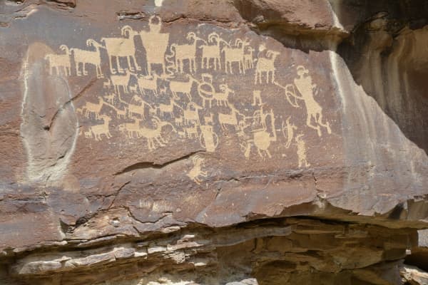
Emery County describes the panel as more than 130 feet long. The dominant art is painted: red figures and symbols in the Barrier Canyon style, which Emery County calls pictographs. The BLM says the site includes both pictographs, which are painted, and petroglyphs, which are pecked into the rock. In the BLM's words, "the ghostly red figures here stand watch over the San Rafael River."
Who made it
Emery County says the pictographs are believed to be more than 2,000 years old and were made by the Barrier Canyon culture, a hunter-gatherer society that moved through the area. A KSL field guide describes them as an Archaic-age people who lived in caves or brush shelters and says the main panel was painted "well over 2,000 years ago." Emery County says the Fremont culture later carved petroglyphs here, between about 2,000 and 700 years ago. Reporting on a 2025 vandalism case, the Deseret News said some bighorn sheep petroglyphs at the site were carved as long as 3,000 years ago. Dates for rock art are hard to pin down, and the sources give ranges rather than a single figure.
How it was painted
Both Emery County and KSL say the red pigment was likely powdered hematite mixed with a liquid, possibly animal fat or egg. KSL adds that the artists may have used fingers or brushes made of fur or grass, and that pigment applied to freshly exposed sandstone soaked in and lasted.
The 1996 restoration
The panel has a long history of damage. KSL says the figures were restored in 1996 as part of Emery County's Utah Centennial project. The interpretive signs at the site explain more of that history, and they are worth reading before you look.
The CCC names
The BLM notes a boulder at the site carries names carved by members of a Civilian Conservation Corps crew that was building a bridge across the canyon. That crew's best-known work is a few miles south: the Swinging Bridge.
Viewing it with respect
This is the part of the trip that matters most. The Buckhorn panel is irreplaceable, and KSL notes that many Indigenous people consider sites like it sacred. It has been damaged repeatedly, most recently in January 2025.
The 2025 vandalism
According to the Deseret News, law enforcement found graffiti on Jan. 17, 2025: someone had scrawled "Silvia P." across four bighorn sheep petroglyphs at the panel. The BLM said the vandalism caused permanent damage. Nicholas Lafazio, the BLM Price Field Office manager, said at the time that "vandalizing archaeological sites erases the stories of our past" and that the site "attracts visitors from around the world to Emery County." The BLM asked anyone with information to contact Price Field Office law enforcement at 435-636-3600.
The law
The site is protected under the Archaeological Resources Protection Act, the Deseret News reported. The National Park Service says the law, signed Oct. 31, 1979, makes it illegal to excavate or traffic in archaeological resources on public land without a permit. Penalties for injuring or destroying U.S. property under the act can reach 10 years in prison and a $250,000 fine, according to the Park Service.
The rules that protect the panel
The Utah State Historic Preservation Office's guidance and the BLM's advice line up. In practice:
- Don't touch the art. Oils from your hands speed erosion, the state historic preservation office says. The BLM asks visitors to keep hands and objects off rock imagery entirely. That includes leaning on the wall, tracing figures with a finger or setting a phone against the rock for a photo.
- Don't add anything. No chalk, no water to "bring out" the color, no rubbings, no new marks of any kind. The historic preservation office is blunt: don't make your own.
- Leave everything where it is. The office says to leave all artifacts in place, and that items more than 50 years old count as archaeological material.
- Stay on the trail and keep kids on it. The office specifically asks parents to teach children to stay on trails at archaeological sites.
- Keep pets leashed or leave them home, since animals can damage sites without anyone noticing.
- Don't build cairns. The office says land managers already mark trails, and cairns have been built from artifacts.
- Report damage. If you see fresh graffiti, call the BLM Price Field Office, or email the state's public archaeology team with the location and photos.
The BLM's own summary is short: "leave only footprints and take only pictures."
Photography tips that keep the art safe
You don't need to get close for a good picture. The panel runs more than 130 feet, so you can photograph it from the trail. Never steady a phone, a tripod leg or a hand against the rock.
Camping and staying overnight
The drive is long enough that many Utah Valley visitors make Buckhorn an overnight.
Buckhorn Draw sites
The BLM lists 26 individual sites along Buckhorn Draw Road, each with a numbered post, a fire ring and a picnic table, plus seven group sites. Individual sites are $15 a night and group sites $50, paid by fee envelope or with scan-and-pay in the Recreation.gov app. The stay limit is 14 days, and there are no hookups. Vault toilets sit at several clusters of sites and at the pictograph panel.
Not every site works for every vehicle. The BLM and Recreation.gov list which sites fit RVs and small trailers, and both say a pair of sites on a sandy spur require high clearance and four-wheel or all-wheel drive. The two pages number those sites slightly differently, so read the posts on site. Recreation.gov also tells visitors not to park or camp in washes because of flash floods, not to stop in blind turns, and not to park in a fee site unless you are camping in it.
Swinging Bridge campgrounds
At the south end of the canyon, where Buckhorn Wash meets the San Rafael River, the BLM runs three small loops: Swinging Bridge North with six sites, Swinging Bridge South with 12, and an equestrian loop with six sites and corrals. Sites are $15 a night with a 14-day limit. The BLM says plainly that "there is no drinking water or trash removal services at these campgrounds," so pack out everything.
The bridge itself is the reason to stop even if you don't camp. The BLM says the San Rafael Swinging Bridge is Utah's oldest intact suspension bridge, 160 feet long, built by the Civilian Conservation Corps in 1937, and it was the only bridge over the river until the adjacent bridge was built in 1990.
Other stops worth adding
- The Wedge Overlook. The UGS says the Wedge sits on the rim of the Little Grand Canyon, the deepest part of the San Rafael River canyon, with a sheer drop of about 1,200 feet below. From the Green River Cutoff Road, it is a 6.6-mile drive out the Wedge Road (Emery County Road 405). Stay well back from the edge.
- The dinosaur track at mile 1.6 of Buckhorn Draw Road, described above.
- Little Grand Canyon hiking. The BLM's Swinging Bridge page mentions a 17-mile, point-to-point, unmaintained route with river crossings. That is a serious undertaking, not an add-on.
- Jurassic National Monument. The BLM's Swinging Bridge page lists the monument as open seasonally from April through October, Thursday through Sunday, 10 a.m. to 5 p.m., so it is closed in late fall and winter. Our guide to Cleveland-Lloyd and the Mill Canyon tracks covers it for spring.
Wildlife is part of the draw. The BLM says mule deer use the sage and riparian areas, bighorn sheep appear in side canyons, and antelope are seen near the river, mostly in the morning and evening.
When to go
Mild weather makes spring and fall the easiest seasons for most families, and Recreation.gov warns that flash flood risk is present throughout the Swell, which matters most when storms are in the forecast. Winter visits are possible, but Recreation.gov warns that county roads may be impassable for two-wheel-drive vehicles when wet or icy, and the UGS says the backway is not safe to drive year-round. After a snowstorm or a heavy rain, the gravel can turn to mud that is hard to drive even with four-wheel drive.
For a late-fall trip, such as over Thanksgiving break, plan around short daylight. Leave Provo early enough to reach the gravel in the morning and to be back on pavement before dark. US-6 over Soldier Summit is a mountain highway in winter, so check UDOT's road weather alerts before you go. Our guide to winter tires and canyon driving in Utah covers what to have on the car.
What it costs
- Entrance: no fee listed by the BLM for the panel.
- Camping: $15 a night for an individual Buckhorn Draw or Swinging Bridge site; $50 for a Buckhorn Draw group site.
- Fuel: the biggest real cost for most trips. Top off before you leave pavement, since the BLM lists no services along Buckhorn Draw beyond toilets and campsites.
What to bring
- Water and food for everyone, because there is no drinking water at the campgrounds.
- A full tank and a spare tire you know how to change; Recreation.gov's notes for the Swell recommend carrying an emergency kit for self-rescue.
- A printed or downloaded map. Cell coverage in the Swell is unreliable, and the BLM, the UGS and Emery County all give slightly different mileages.
- Trash bags to pack everything out.
- Layers. Canyon floors are cold in the shade in late fall even on sunny days.
- Binoculars, which help with the higher figures and with spotting bighorn sheep.
Who should skip it
- Anyone in a low car after rain or snow. The roads are usually fine for a passenger car when dry, but they can become impassable when wet or icy, by Recreation.gov's account.
- Visitors who want a big hike. The panel is next to the road. If you want miles, plan a separate hike or pair it with the slot canyons farther south.
- Groups that can't keep hands off. If you're bringing young children who will want to touch the wall, plan to hold hands at the panel, or save the trip for when they're older.
- Anyone with less than a full day. From Provo, this is a long day even without stops. An overnight is the better plan.
Safety and conditions
- Flash floods are a risk throughout the Swell. Don't park or camp in washes, and don't enter narrow side canyons when storms are forecast.
- Blind turns on the canyon road make stopping dangerous; use pullouts and day-use parking.
- Wilderness boundaries sit on both sides of Buckhorn Draw. The BLM prohibits motorized vehicles, bicycles and power tools in designated wilderness, and Recreation.gov lists the San Rafael Swell wilderness areas that were designated under a 2019 federal lands law, along with the few routes that remain open to off-highway vehicles.
- Cliff edges at the Wedge Overlook drop about 1,200 feet, according to the UGS.
What to check before you go
- Road conditions: call the BLM Price Field Office at 435-636-3600, especially after any rain or snow.
- US-6 traffic and construction: check UDOT Traffic for lane closures in Spanish Fork Canyon and road weather alerts over Soldier Summit.
- Weather in Emery County, including flash flood watches in warm months.
- Campsite fees and rules on the BLM's Buckhorn Draw and Swinging Bridge pages or on Recreation.gov, since fees can change.
- Daylight hours, which are short in late fall and winter.
Planning a bigger trip
Buckhorn pairs naturally with the rest of the Swell. Our Goblin Valley and San Rafael Swell guide covers the state park and the southern side of the Swell, and the Green River and Crystal Geyser guide covers the town at the east end of this stretch of I-70. For more ideas sorted by driving time, see our day trips from Provo. Clear nights in the Swell are dark enough that stargazing near Provo is worth reading if you plan to camp.
The short version
The Buckhorn Wash panel is a 130-foot wall of Barrier Canyon style paintings beside a gravel road in the northern San Rafael Swell. Reach it from Castle Dale on the Green River Cutoff Road or from I-70 exit 131, check road conditions with the BLM before you leave Provo, bring all your water, and look without touching. The art has survived 2,000 years of weather and more than a century of graffiti; it only lasts if visitors leave it exactly as they found it.
Related Guides
- Goblin Valley & the San Rafael Swell from Provo
- Rock Art in Utah: Petroglyphs, Pictographs and How to Visit Respectfully
- Nine Mile Canyon, Helper and Price From Provo
- Little Wild Horse and Bell Canyons: Utah's Most Approachable Slot Canyon Loop
- Cleveland-Lloyd Dinosaur Quarry and the Mill Canyon Tracks from Provo: The Allosaurus Weekend
- Green River, Crystal Geyser and Melon Days from Provo
- Best Day Trips from Provo
Frequently Asked Questions
Where is the Buckhorn Wash pictograph panel?
How do you get to the Buckhorn panel from Provo?
Do you need four-wheel drive to reach the panel?
Is there a fee to see the Buckhorn panel?
How old is the Buckhorn Wash rock art?
What is the difference between a pictograph and a petroglyph?
Can I touch the rock art at Buckhorn Wash?
Are there bathrooms at the Buckhorn panel?
Sources
The facts in this guide were checked against these sources. Hours, fees and rules change, so confirm anything time-sensitive with the source before you go. How we make Provo.com.
- Buckhorn Panel, Bureau of Land Management. Checked November 22, 2026.
- Buckhorn Draw Dispersed Campground, Bureau of Land Management. Checked November 22, 2026.
- San Rafael Swinging Bridge Campground, Bureau of Land Management. Checked November 22, 2026.
- Recreation.gov: Buckhorn Draw, Recreation.gov. Checked November 22, 2026.
- San Rafael Swell Recreation Area, Recreation.gov. Checked November 22, 2026.
- GeoSights: Little Grand Canyon, Wedge Overlook, and Buckhorn Draw Scenic Backway, Utah Geological Survey. Checked November 22, 2026.
- Buckhorn Pictograph Panel, Emery County. Checked November 22, 2026.
- Utah Anti-Vandalism Campaign, Utah State Historic Preservation Office. Checked November 22, 2026.
- Petroglyphs Hidden in Plain Sight: Insights into the Prehistoric Rock Imagery of Utah's West Desert, Bureau of Land Management. Checked November 22, 2026.
- Archaeological Resources Protection Act, National Park Service. Checked November 22, 2026.
- UDOT completes safety upgrades, launches next phase of major improvements on US-6, Utah Department of Transportation. Checked November 22, 2026.
- Southern Utah petroglyphs vandalized at Buckhorn Wash, Deseret News. Checked November 22, 2026.
- Utah Field Guide: Buckhorn Wash Pictograph Panel, KSL. Checked November 22, 2026.