
There is one place in Utah where the rule is not "stay on the trail." At Goblin Valley you are allowed to walk out into the landscape and climb on it, and for anyone who has spent years telling children not to touch things in national parks, the effect is close to liberating.
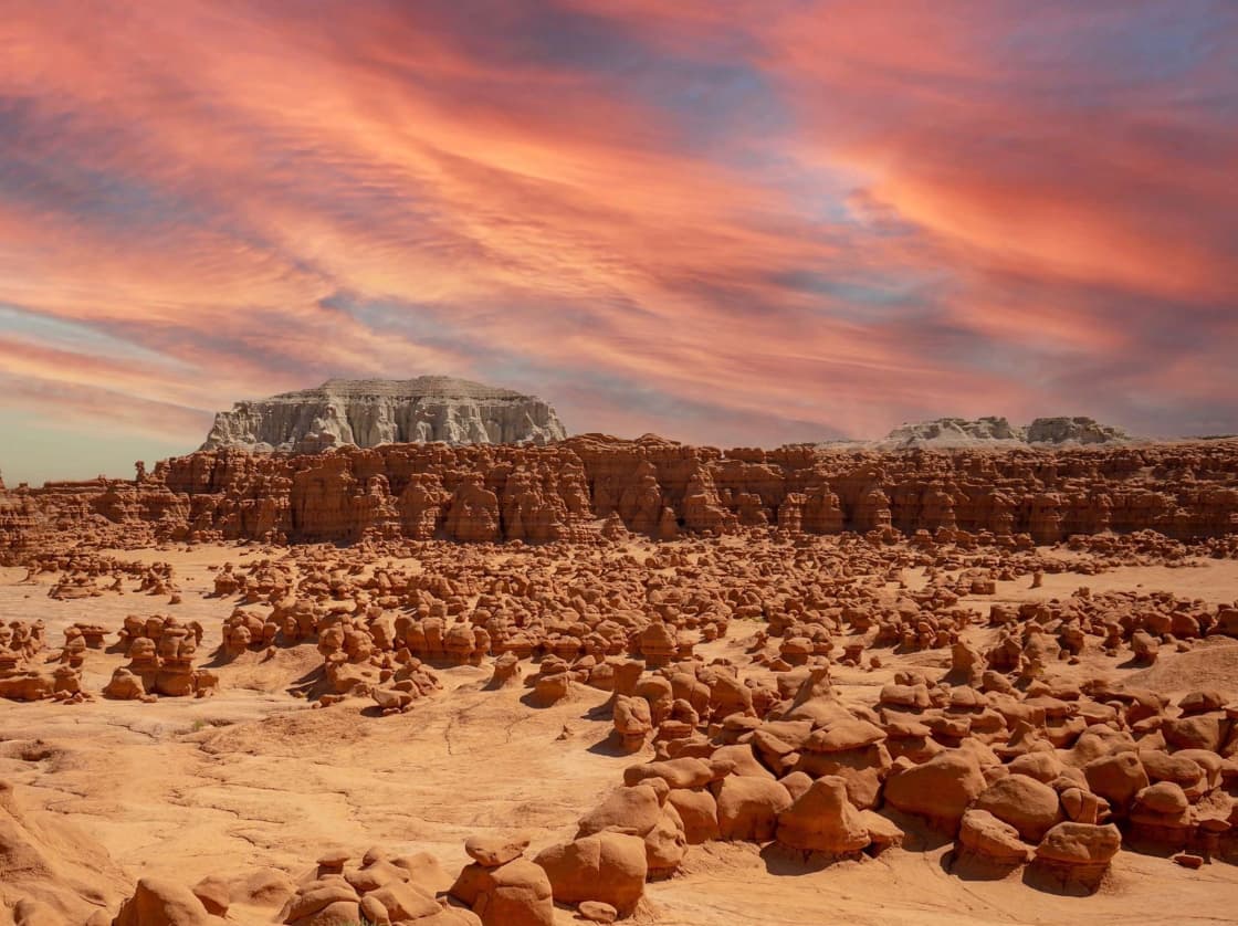
The park is about three hours from Provo, sitting in the enormous, largely empty country around the San Rafael Swell. The formations that give it its name are thousands of squat, rounded sandstone shapes spread across a valley floor, and the honest description is that it looks less like scenery than like a film set.
Fees, conditions and permit requirements change. Confirm current details with Utah State Parks before you go, and use the official fee page rather than any third-party listing.
What the goblins are
The formations are the product of two rock layers eroding at different rates — a softer stone weathering out from under a more resistant cap, over a very long time, leaving thousands of mushroom-shaped hoodoos standing across a basin.
What makes the place unusual is the density and the scale. They are not scattered features in a wide landscape; they fill the valley floor, close enough together to walk among, and short enough that an adult can see over most of them. That combination is why it works as a place to explore rather than to view.
The color is the other thing photographs undersell. In flat midday light it is muted. In early morning or late afternoon the whole basin turns deep orange, which is the difference between a decent photograph and a memorable one.
The drive from Provo
South on I-15, then east across central Utah into the San Rafael country, with the park located roughly 50 miles southwest of Green River off State Route 24.
Budget around three hours and treat the second half as remote. Services thin out substantially — fuel, food and cell coverage all become unreliable well before you arrive. The standard local practice is to fill up in the last real town rather than gambling on the final stretch.
The drive itself is part of the appeal for anyone who likes empty country. It crosses some of the least-populated landscape in a state that has a great deal of it.
What it costs
Utah State Parks lists day-use fees at $20 for a private vehicle and $10 for a motorcycle, bicycle or pedestrian, with a $5 per-person fee for commercial vehicles. Day-use passes are valid until 10pm the day after purchase, which is more generous than most and effectively covers an overnight stay elsewhere plus a second morning.
Camping in the main campground, which has no electrical hookups, is listed at $45 including a pass for one vehicle, with an extra vehicle fee of $20. Yurts are listed at $150 plus tax, with a maximum of two dogs permitted for an additional $20 each. A group campground is listed at $200 plus tax for up to 40 people and 10 vehicles.
Two specialty permits are listed: a drone permit at $15 per drone, and a Goblin's Lair rappel permit at $4 per person.
The park states explicitly that it does not honor rates posted on third-party websites. Given how many aggregator sites carry stale Utah park pricing, that is worth taking seriously.
Camping, and why you should book early
The campground is small — around two dozen sites plus a group site and two yurts, with centrally located restrooms and showers. Utah State Parks has described bookings opening four months to the day in advance.
Small plus popular equals booked. If your trip depends on camping inside the park, that is the piece to arrange first and the reason to plan months rather than weeks ahead. The yurts in particular go quickly.
The case for staying rather than day-tripping is strong here, and it is mostly about the sky.
The night sky, which is the real reason to stay
This is one of the darkest accessible places in a state full of dark places. Remote, dry, high desert, with essentially no light pollution in any direction.
The Milky Way is plainly visible on a clear moonless night in a way that people who have only seen the sky from the Wasatch Front generally have not experienced. Combined with the formations in silhouette or lit by moonlight, it is the park's most memorable hour and the one day-trippers miss entirely.
Check the moon phase when booking. A bright moon washes out the stars and lights the goblins beautifully — they are two different trips, and worth choosing deliberately.
Why children love it
The freedom to leave the path is the whole thing.
Most protected landscapes require children to walk in a line and touch nothing, which is a reasonable rule and a difficult afternoon. Here they can run out into the valley, climb, hide, and explore, and the terrain is forgiving enough that this is a normal activity rather than a risk.
The practical caveats are simple. Sightlines are deceptive — a child can disappear behind formations quickly, so agree a boundary and a meeting point. Rock is abrasive and knees suffer. And the valley is exposed, so heat and sun management is not optional.
Bring more water than you think and a hat for everyone.
The heat, stated plainly
Utah State Parks identifies spring and autumn as the best times to visit and notes that summer temperatures can exceed 100 degrees.
That is not a comfort note. This is exposed desert with no shade, no water source and no easy escape, and midsummer midday here is hazardous rather than merely unpleasant. The guidance to carry at least a gallon of water per person per day in summer is the park's own.
If you do come in summer, treat it as an early-morning and late-evening destination and spend the middle of the day somewhere with air conditioning. Winter, at the other end, brings below-freezing nights and occasional snow, which is atmospheric and cold for tent camping.
Flash floods, which are the actual danger
The hazard that kills people in this landscape is water, in a place that looks like it has never seen any.
Afternoon thunderstorms in late summer can dump rain miles away, and that water funnels into washes and slot canyons where it arrives fast, with no warning, under a blue sky directly overhead. Utah State Parks names flash flooding in nearby washes and slot canyons alongside lightning as the region's principal safety concerns.
The rule is to check the forecast for the entire upstream drainage, not just for where you are standing, and to stay out of narrow canyons when storms are anywhere in the forecast. If weather builds while you are in one, leave immediately and climb rather than continuing.
Lightning is the related risk. The park's own guidance is to seek shelter in a building or vehicle during thunderstorms, and an exposed valley floor full of short rock formations is a poor place to be caught.
The slot canyons nearby
The area around the park includes some of Utah's better-known slot canyon routes, and they are a large part of why people make the drive.
They vary enormously in difficulty. Some are straightforward walks through narrow rock. Others involve scrambling, downclimbing, route-finding, and occasionally technical equipment, and the gap between the easy and the serious ones is wider than the descriptions suggest.
Assess honestly. Read a current, specific route description rather than a general one, know whether your party can reverse anything it descends, and treat the weather rule above as absolute rather than cautious.
How it became a park
The valley was known to ranchers and to people passing through long before it was protected, and for much of the twentieth century it was simply an odd place in empty country that a few people knew about.
It was surveyed and publicized in the mid-twentieth century, and became a state park in the 1960s. The name has shifted around — it has been called Mushroom Valley and other things — but "goblins" is what stuck, for obvious reasons once you have seen them at dusk.
The film industry noticed it. The landscape has stood in for other planets more than once, which is a reasonable casting decision given that it looks less like Earth than almost anywhere accessible by paved road.
Its protected status also became a public issue after a widely reported incident in which visitors deliberately toppled a formation, which prompted a lot of discussion about what "you can climb on things" should and should not mean. The park's openness depends on visitors not destroying what they came for.
Photography, and the light
This is a landscape that punishes midday and rewards patience.
At noon the light is flat and directly overhead, the shadows collapse, and the formations lose the dimensionality that makes them interesting. The rock reads as beige.
In the hour after sunrise and the hour before sunset, low-angle light rakes across the valley, the shadows separate the formations from each other, and the sandstone turns orange. The same viewpoint produces two completely different photographs six hours apart.
Night photography is the other draw, given the dark skies. Formations silhouetted against the Milky Way is the shot people drive three hours for, and it requires staying overnight, which is one more argument for the campground.
The wider area's other stops
The park is the anchor, and there are several things nearby worth building into a trip.
Rock art is the most significant. The broader region contains important prehistoric panels, some of them among the more remarkable in North America, reachable by road with varying levels of effort. These are fragile and heavily protected — look, photograph, and do not touch or chalk anything.
There are also historic mining remnants and old roads scattered through the Swell, the leftovers of uranium prospecting and earlier ranching. Some are interesting and some are hazardous, and open shafts in this part of the state are a genuine danger rather than a theoretical one.
Between the park and the interstate, the small towns along the route are the last reliable services in either direction, which is worth building into the timing.
Accessibility, honestly
The main viewpoint and the area immediately around it are reachable without difficulty and give a good sense of the place.
The valley floor itself is a different matter. Getting down among the formations involves uneven sand and rock with no formal trail, which is precisely what makes it enjoyable and also what makes it inaccessible to some visitors. There is no version of the descent that is smooth.
For anyone weighing a long drive against what they will be able to do, the honest answer is that the overlook is worthwhile on its own, and the full experience requires walking on rough ground.
Rules that are easy to break by accident
Because the park's headline rule is permissive, people assume there are no others.
Climbing on the formations is allowed; damaging them is not, and that includes moving, chipping or standing on anything precarious. Drones require the permit noted above. Rappelling in the Goblin's Lair requires its own permit.
Pets are permitted with the usual state-park constraints, and yurt stays list a per-pet fee and a two-dog maximum. Leave-no-trace applies with more force than usual in a place with no shade and thin soil — there is nowhere for litter to hide here, and it stays visible for a very long time.
The San Rafael Swell, which is the bigger story
Goblin Valley is a small park inside an enormous geological feature. The San Rafael Swell is a vast uplifted dome of rock, eroded into canyons, reefs and badlands across an area far larger than any park boundary.
Most of it is public land without entrance stations, visitor centers or reliable signage. That is the appeal and the hazard in one sentence. There are extraordinary places out there and very little infrastructure to help you if something goes wrong.
For a first trip, use the park as the base and treat the wider Swell as something to look at from the road. It is not country to improvise in without preparation, a paper map and someone knowing your plan.
Making it a longer trip
Three hours each way is a lot of driving for one small park, which is the argument for stringing it together with something else.
The natural pairing is Moab, which sits further east and turns the trip into a proper weekend. Capitol Reef lies to the southwest and combines well via State Route 24. Some people run the whole loop as a several-day southern Utah circuit taking in Bryce as well.
Our day trips guide sorts the wider region by driving time from Utah Valley, which is the useful frame when deciding how much to attempt.
Practical notes
Fuel before the last stretch. Download maps rather than relying on cell coverage, which is poor to nonexistent across much of the approach and inside the park.
Bring shade if you plan to stay put for any length of time, because there is none. Footwear matters more than at a typical viewpoint stop, since the whole point is walking on rock. And bring more water than the temperature suggests, in the car as well as on your person.
Finally, tell somebody where you are going if you intend to go beyond the park itself. The Swell is big and empty and does not care.
What to tell people who have not been
The most common reaction from first-time visitors is that photographs did not prepare them, and the reason is scale rather than color.
Pictures make the goblins look either enormous or miniature depending on the framing, and neither is right. Most are roughly human scale, which is precisely why walking among them works — they are large enough to hide behind and small enough not to feel like cliffs. That relationship between body and landscape is the thing the photographs cannot convey.
The other thing worth saying in advance is that the park is small. It is not a place you spend three days. It is a place you spend an afternoon and an evening, and the trip is built by combining it with the country around it.
The short version
Three hours from Provo is a valley full of stone goblins that you are allowed to climb on, which makes it one of the best family destinations in Utah. Go in spring or autumn, book camping months ahead if you want it, stay for the night sky, treat summer midday as dangerous rather than uncomfortable, and take flash flood warnings seriously in every slot canyon in the region.
Related Guides
- Moab from Provo
- Capitol Reef from Provo
- Bryce Canyon from Provo
- Best Day Trips from Provo
- Stargazing Near Provo
- Nine Mile Canyon, Helper and Price From Provo
Frequently Asked Questions
How far is Goblin Valley from Provo?
What does Goblin Valley cost?
Can children climb on the goblins?
Do I need reservations?
What is the flash flood risk?
When is the best time to visit?
Are there slot canyons nearby?
Is there a fee for drones or rappelling?
Sources
The facts in this guide were checked against these sources. Hours, fees and rules change, so confirm anything time-sensitive with the source before you go. How we make Provo.com.
- Utah State Parks: Park Fees, Utah State Parks. Checked October 12, 2026.
- Utah State Parks: History, Utah State Parks. Checked October 12, 2026.
- Goblin Valley State Park, Utah State Parks. Checked October 12, 2026.