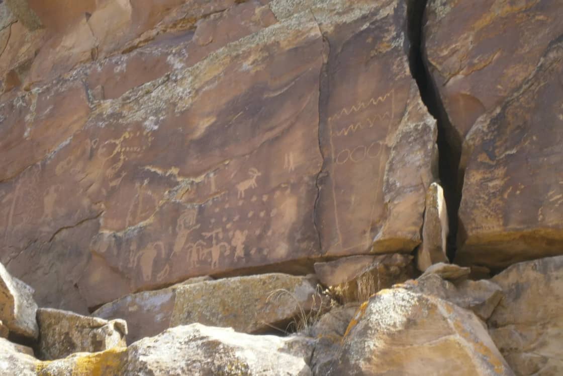
Utah has some of the best-known rock art in North America, and much of it can be reached on a public road or a marked trail. It is also fragile, legally protected, and for many people living today part of a heritage that is not a tourist attraction. This guide explains the basic difference between petroglyphs and pictographs, summarizes how Utah sources describe the main styles, lists public sites within reach of Provo with the access details we could confirm, and sets out the rules and the courtesies that keep these places intact.
We lean on named agencies throughout and say where sources disagree. We also do not publish directions to unmarked sites, and we link only to places that an agency itself lists for visitors. It is a companion to our guide to the Fremont culture of Utah, which covers who the Fremont were and which museums hold their material, and to our account of the Timpanogos people of Utah Valley, the Native people recorded in the valley when Europeans first wrote about it.
Quick facts
| Topic | What to know | Source or check |
|---|---|---|
| Petroglyph | Image cut, chipped or ground into rock | National Park Service |
| Pictograph | Image painted onto rock | National Park Service |
| Main styles in Utah sources | Barrier Canyon (Archaic), Fremont, Ute, plus Ancestral Puebloan and Paiute imagery | Utah state pages, NPS |
| Closest large area from Provo | Nine Mile Canyon, about 46 miles long | Bureau of Land Management |
| Hardest hike covered here | Great Gallery, about 7 miles round trip, 5 hours or more | NPS, Canyonlands |
| Core rule | Look and photograph, do not touch, do not chalk, do not trace, do not collect | NPS, Utah SHPO, BLM |
| Main federal law | Archaeological Resources Protection Act of 1979 | NPS |
Petroglyphs and pictographs
The National Park Service's "Learn to Look at Petroglyphs and Pictographs" article gives the simplest definitions. Petroglyphs are images made by removing rock: they are cut, chipped or ground into a surface. Pictographs are images painted onto rock. The two words are often used loosely, and many visitors call everything a petroglyph. The difference matters for a practical reason, because paint and carved surfaces are damaged in different ways, and both are damaged by contact.
How they were made
The NPS article describes several techniques. Makers of petroglyphs struck or ground one rock against the surface, or struck a rock held in one hand with a hammerstone held in the other. Blunt, pointed and edged tools left different marks. The NPS gives an example from Yosemite of carvers cutting through dark, oxidized rock to expose the lighter rock beneath. The NPS's Horseshoe Canyon page notes that the Great Gallery includes pecked and painted figures.
For pictographs, the NPS says makers used brushes, stencils and other tools, and sometimes blew paint from their mouths. The most durable pigments were ground minerals mixed with a binder, while plant-based washes faded more easily. That helps explain why some painted figures survive for many centuries in sheltered alcoves and others have disappeared.
Why the terms are not neutral
The NPS notes that archeologists and anthropologists have been moving away from the phrase "rock art," in part because Native Americans point out that their ancestors had no word for art or a meaning like it. A 2021 article by Ellen Fagg Weist for the Utah Department of Cultural and Community Engagement says some tribal elders prefer the term "rock writing." The Bureau of Land Management's Newspaper Rock brochure for Bears Ears uses "rock writing" in its own rules. Throughout this guide we use "rock art" because it is the term on most public signs and agency pages, but it is not the only word, and the choice is not trivial.
Dating and meaning
The NPS says the images are "hundreds or thousands of years" old, and that setting, archaeological remains and ethnographic evidence help clarify their context. It is blunt about the limits: no one living today is sure what many of them mean. A deer might mark a hunting place, represent a ritual or express a feeling, and clues can come from the setting, such as alignments with the sun. The NPS cites spiral petroglyphs at Hovenweep as a possible example of solar calendars, which it presents as a possibility. It also lists oral traditions passed through generations as a source of evidence about meaning.
Utah dates for the same style differ by source, which is normal for rock art and worth keeping in mind when a sign and a website disagree. We give both where we found both below.
Styles that Utah sources describe
Barrier Canyon style
Utah's Arts and Museums site describes paintings in the Barrier Canyon style as Utah's earliest known art on rock, showing human-like figures on canyon walls in Utah and the northern Colorado Plateau. It says some images may date to roughly 8,000 to 6,000 years ago and attributes them to scattered bands of Archaic Native Americans. It also names the BCS Project, a nonprofit building a photographic inventory of the style.
The National Park Service's Horseshoe Canyon page gives a different range, saying the style is believed to date to the Late Archaic period, roughly 2000 BCE to 500 CE. It describes the figures as tapered and life-size, lacking arms and legs but often containing intricate designs, and says nomadic hunter-gatherer groups made them while using the canyon as a seasonal home. The page does not name the specific peoples involved. The NPS's Courthouse Wash page gives yet another range of 1,500 to 4,000 years ago for the figures there, and notes that a later addition on that panel may be Fremont, Puebloan or Ute and Paiute work. When you see a number on a sign, treat it as the current estimate of that agency, not as settled fact.
Fremont style
The Utah Historical Society's youth history site says Fremont people lived in central and northern Utah, in the Great Basin, and that the rock art they left across the region is similar in style. Fremont panels often show shield-bearing figures, animals and geometric designs. A Utah State Historic Preservation Office blog post documents shield iconography in eastern Utah, and the NPS describes Fremont petroglyphs in Capitol Reef and Dinosaur National Monument. Our Fremont guide covers the dates and what happened around 1250, so we will not repeat it here.
Dates for the Fremont vary by source, from about 300 to 1300 CE at Capitol Reef to about 500 BC to 1250 AD on the Utah Historical Society's page. The NPS says many of Dinosaur National Monument's designs are attributed to Fremont peoples.
Ute and Paiute imagery
The BLM's Sego Canyon page says the site holds three culturally distinct styles: Fremont, Ute and Barrier-style. A Utah State Historic Preservation Office survey described by state sources recorded Ute and Paiute imagery alongside several Fremont styles and Barrier Canyon style. Utah's I Love History site says Utes and Paiutes became the main people to use much of eastern Utah's land after the Ancestral Puebloan and Fremont peoples left. We did not find an agency source that gives a precise date range for Ute panels at Sego, so we do not give one.
Other traditions
The 2021 Utah Department of Cultural and Community Engagement article describes Great Basin rock art as commonly abstract in earlier periods, with curvilinear and rectilinear designs, wavy lines and cross-hatching, and says Four Corners sites feature grand panels while northern Utah has carved figures on horizontal limestone or sandstone. It lists the Archaic period as about 7,000 to 100 BC and the Fremont period as about 100 BC to AD 1300, which is yet another framing, so again compare the exact range your source uses.
Public sites reachable from Provo
Access and fee details below come from official pages we read on November 10, 2026. Conditions change, and several of these roads and trails are remote. Our guides to day trips from Provo cover other long drives.
Nine Mile Canyon (Carbon and Duchesne counties)
The Bureau of Land Management says most visitors approach from Wellington, south of Price, driving northeast on Soldier Creek Road. The canyon is about 46 miles long. The BLM page lists no fee. It names a picnic area, restrooms and a historic homestead at Cottonwood Glen, trailheads, parking and restrooms at Daddy Canyon, and trailheads to rock art sites and a Fremont village past Frank's Canyon in Cottonwood Canyon. It asks visitors to respect private property, because side canyons may cross it. The BLM Price Field Office, at 125 South 600 West in Price, answers questions at 435-636-3600. The page does not cover road conditions or seasons, so call before you go.
Our Nine Mile Canyon, Helper and Price guide covers the route from Provo via US-6 over Soldier Summit. We did not confirm a one-way drive time to the canyon mouth from an official source, so use a routing app and plan on a full day.
Great Gallery, Horseshoe Canyon (Canyonlands National Park)
The Great Gallery is the best-known panel in Horseshoe Canyon. The NPS describes it as including life-sized figures with intricate designs and as among the most significant ancient rock markings in North America. It combines pictographs and petroglyphs, according to the NPS, and most of the canyon's markings are painted in the Barrier Canyon style.
Access is the main challenge. The NPS says two-wheel-drive vehicles can usually travel the 30-mile graded dirt road from UT 24 near Goblin Valley State Park, or the 47-mile dirt road south from Green River. It lists the drive as about 2.5 hours from Moab or 1.5 hours from Green River, and warns that rain or shifting sand can quickly change road conditions. It also says not to rely on a GPS unit and to use a map. Our Goblin Valley guide puts that park at about three hours from Provo, so a trip to the Horseshoe Canyon trailhead is a long day or an overnight, which is our estimate and not an NPS figure.
The hike to the Great Gallery is about 7 miles round trip and takes five hours or more. It is strenuous, with a steep 780-foot descent at the start and a steep climb back. Water is the main safety issue: the park recommends one gallon per person, says there is no water above the rim, and says sources in the canyon are unreliable. From June through August the NPS says the hike can be dangerously hot, and suggests finishing before noon or starting after 4 p.m. with a light for each person. The rules it lists include no pets on the trail or below the rim, a group limit of 20 hikers, and no overnight camping inside the park boundary. The page lists no fee, so check the park's alerts and road conditions pages. Rangers lead guided walks in spring and fall, which are also about 7 miles and last 4 to 6 hours.
Sego Canyon (near Thompson Springs)
The BLM's Sego Canyon Rock Art Interpretive Site page says to take Exit 187 off I-70, drive State Highway 94 through Thompson and continue about three miles to Sego Canyon. It says major rock art panels are visible from the road, and that a ghost town and coal mine ruins are nearby. It suggests at least a half day. The page lists no fee, hours or rules, and gives the BLM Moab office phone as 435-259-2100. Because this site holds Fremont, Ute and Barrier-style imagery in one place, it is one of the most useful stops for comparing styles. It is also a route that overlaps our Moab guide, which puts Moab at about three and a half to four hours each way.
Capitol Reef National Park
The Fremont petroglyph panels along Utah State Route 24 have two boardwalks, according to the NPS, and the NPS says not to touch the carvings. Our Capitol Reef guide puts the visitor center about 180 road miles from Provo, roughly three and a half hours. The park's fee page lists a $20 private-vehicle pass, $15 for motorcycles and $10 for individuals on foot or bicycle, with a $35 annual pass, and says visitors under 16 do not need a pass. It does not say whether the Highway 24 petroglyph area requires a fee, and our Capitol Reef guide notes the main road through the headline scenery is free, so ask the park at 435-425-3791 if it matters for your plans.
Dinosaur National Monument
The NPS page for viewing petroglyphs and pictographs at Dinosaur lists several sites. Swelter Shelter is half a mile east of the Quarry Visitor Center on Cub Creek Road, an easy walk of about 200 feet, with petroglyphs and pictographs. The Cub Creek stops are 9 miles east, with large lizard petroglyphs at the steeper Stop 14. Deluge Shelter, with painted pictographs, is a 4-mile moderate round-trip hike from Jones Hole Fish Hatchery. McKee Spring is 22 miles from the Quarry Visitor Center via Island Park Road, and Pool Creek is 37 miles from the Canyon Visitor Center via Echo Park Road. Island Park Road and Echo Park Road are impassable when wet, and Pool Creek may require high-clearance four-wheel drive when dry. The monument's number is 435-781-7700. Our Uinta Basin and Dinosaur Country loop puts the full loop from Provo at about 342 miles and seven hours of driving, by a routing estimate, so rock art here is best combined with a longer trip.
The legal rules
Federal law
The National Park Service says federal laws protect archeological resources on NPS and other federal lands, naming the Archaeological Resources Protection Act, or ARPA, as one example. It says courts can penalize looters with fines, years in prison or probation, and lists as things not to do: digging into sites, removing artifacts, vandalizing sites, such as etching around or lifting rock art, and using metal detectors. Specific dollar penalties appear in different NPS materials with different figures, and the statute itself sets tiers that depend on the value of the damage, so we do not quote them here. The statute text is on the government's U.S. Code pages if you need the exact amounts. As summarized in our Fremont guide, vehicles and equipment used in a violation can be confiscated.
In late 2025, Utah media reported a prosecution tied to petroglyph damage. A Kane County case ended with a woman sentenced to probation and nearly $15,000 in fines and restitution, according to reports we found, and those reports said federal law applied. We cite them only as examples that enforcement happens, not as a guide to likely penalties.
Utah law
Utah's State Historic Preservation Office and Division of State History administer state antiquities programs. The Utah legislature considered HB 536 in 2026, which as introduced would extend the state's graffiti-on-public-lands offense to cover natural and archaeological features, and we could not confirm that it passed. A 2021 state article says the legislature created a cultural site stewardship program administered by the Division of State History. We could not pull the current text of Utah's antiquities statutes today, so anyone who needs precise state penalties should read the Utah Code on le.utah.gov or ask the Division of State History.
What the SHPO tells visitors
The Utah SHPO's archaeological site etiquette page, archived and kept for reference, says to stay on trail to protect buried artifacts and to camp in designated spots. For rock art and inscriptions, it says you may photograph or draw them, but should not touch them and should never use chalk or water on them. If you see graffiti, it says not to try to fix it, because that could cause more damage, and to photograph it if you can and report it. If you witness damage, it advises not confronting the person and telling a ranger, archaeologist or agency staff.
How to visit respectfully
- Do not touch. The NPS says oils from hands and skin can leave marks. The BLM's Bears Ears "Visit with Respect" material and the Cedar Mesa planner give the same direction, and the Cedar Mesa planner says never to chalk, trace or otherwise touch rock art.
- Do not add your own marks. The NPS says plainly, "Please do not make your own marks on petroglyph and pictograph sites." It says re-pecking or re-painting does not restore an image but destroys the original.
- Do not trace, rub or chalk. The Dinosaur National Monument page says tracings or rubbings can ruin the designs. The Utah SHPO says never to use chalk or water.
- Do not apply anything to improve a photo. The NPS says not to put any substance on a panel to make it easier to photograph or draw.
- Leave artifacts. The Utah SHPO says you may photograph, measure or draw an artifact if it is safe, but return it where you found it, because removal prevents archaeologists from learning about the people who left it.
- Stay on trails and off boulders and walls. The Utah SHPO says not to climb fragile walls or try to put rocks back in place.
- Treat the site as you would a home or a place of worship. That is NPS wording, and the NPS adds that markings are part of the heritage of descendant peoples and that vandalism disrespects them.
- Check before you go. The NPS recommends checking the visitor center or website for what is known about the images, which areas are damaged or closed, safety concerns such as weather or terrain, and how to report vandalism.
- Photographing is allowed in the sources we read. The Utah SHPO and the NPS say you may photograph or draw rock art. Check each site for its own limits on drones or commercial photography, which our sources did not cover.
Tribal perspectives
Dinosaur National Monument's page says many of the designs are still held sacred and suggests consulting modern Native American groups, such as the Ute, who it describes as descendants of the Fremont peoples, for meaning and context. The Capitol Reef narration from Rick Pickyavit, identified by the NPS as a Southern Paiute narrator, cautions that the meaning of the petroglyphs is uncertain, as noted in our Fremont guide. The NPS also says oral traditions are a source of evidence. We have not interviewed tribal representatives for this guide, and we do not speak for any nation. If a site, a museum or a tribal office offers guidance, follow that over this page. For the history of the Native people recorded around Utah Lake, see our Timpanogos guide, which also explains the unsettled dispute over how the Timpanogos are classified.
Safety
Most of the risk at rock art sites is ordinary desert risk.
- Heat and water. The NPS gives a gallon per person at Horseshoe Canyon and warns of dangerous heat from June through August.
- Roads. Dinosaur National Monument says some roads are impassable when wet, and Canyonlands says weather and shifting sand can change road conditions quickly.
- Navigation and signal. The NPS says not to rely on GPS to find Horseshoe Canyon. Download maps and tell someone your plan.
- Old structures. The Utah SHPO says treat structures that look unsafe as unsafe, watch for nails and sharp objects, and know that old mines may have open shafts and animals may nest in rocks.
- Flash floods. Our Goblin Valley guide notes that late-summer thunderstorms can send water through washes and slot canyons from storms miles away.
Who should skip it
Skip the Great Gallery hike if you cannot manage a steep 780-foot climb out at the end of a 7-mile day in an area with no reliable water. Skip the long dirt roads in or after rain. Families with very young children may prefer the roadside panels at Sego Canyon or the 200-foot walk at Swelter Shelter, where the official pages describe easy access. If you cannot keep your hands off the rock, or you are planning to collect souvenirs, do not go.
Before you go
- Confirm access, hours and any fees on the official page the week you leave. Everything above was read on November 10, 2026.
- Call the managing office for road conditions: BLM Price (435-636-3600), BLM Moab (435-259-2100), Dinosaur National Monument (435-781-7700) or Capitol Reef (435-425-3791).
- Bring binoculars. Several NPS pages say they help at distant panels.
- Carry water, food, sun protection, a paper map and a full tank.
- Read the wayside signs. They carry the most recent interpretation for that panel.
- If you find damage, follow the SHPO's advice and tell a ranger or agency staff. A 2021 Utah state article lists a BLM vandalism hotline at 800-722-3998.
- If you come across an unmarked site or artifact, the Utah SHPO says to tell the landowner or manager, and that the state Antiquities Section can help connect you with the landowner.
Frequently Asked Questions
What is the difference between a petroglyph and a pictograph?
Can I touch petroglyphs or pictographs?
Is it illegal to damage or take things from rock art sites?
What is Barrier Canyon style rock art?
What is the closest rock art to Provo that the public can visit?
How hard is the hike to the Great Gallery in Horseshoe Canyon?
Who made the rock art, and what does it mean?
What should I do if I see damage or find an artifact?
Sources
The facts in this guide were checked against these sources. Hours, fees and rules change, so confirm anything time-sensitive with the source before you go. How we make Provo.com.
- Learn to Look at Petroglyphs and Pictographs, National Park Service. Checked November 10, 2026.
- Horseshoe Canyon, National Park Service. Checked November 10, 2026.
- Petroglyph and Pictograph Sites, National Park Service. Checked November 10, 2026.
- Looting & Vandalism, National Park Service. Checked November 10, 2026.
- 9 Mile Canyon, Utah, Bureau of Land Management. Checked November 10, 2026.
- Sego Canyon Rock Art Interpretive Site, Bureau of Land Management. Checked November 10, 2026.