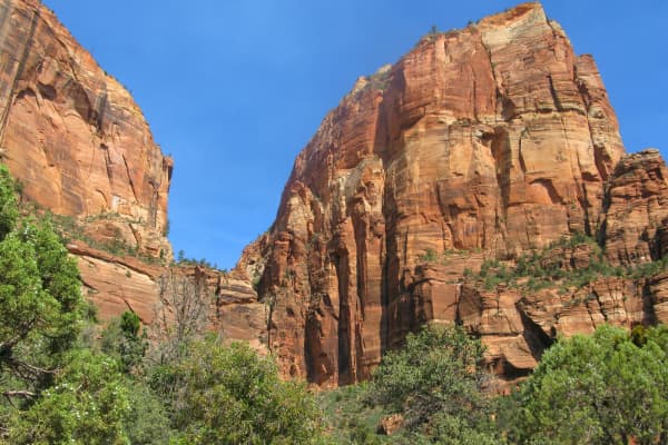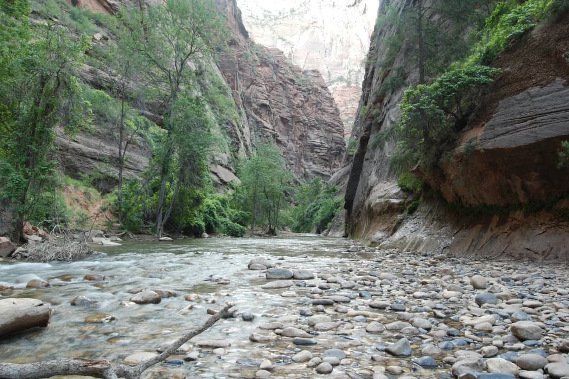
The Narrows is the stretch of Zion Canyon where the North Fork of the Virgin River fills most of the floor and the trail is the river itself. The National Park Service describes walls 1,000 feet tall and a river "sometimes only 20-30 feet wide." Most people hike it from the bottom, wading upstream from the end of the Zion Canyon Scenic Drive with no permit. A smaller number walk the full 16 miles from the top, starting at a private ranch outside the park, and that trip takes a wilderness permit. Either way, the river sets the terms: the Park Service closes the Narrows to all travel when the flow tops 150 cubic feet per second, closes the top-down route at 120, and shuts the canyon during any flash flood warning.
This guide is written for a Utah Valley reader planning from Provo. It covers the two routes, the permit system, how flow levels and flash floods close the river, why November water calls for a drysuit, how the shuttle schedule affects your start, what it costs, what to bring and who should pick a different hike. We have not hiked the Narrows for this article. Every rule, number and date below comes from the National Park Service, Recreation.gov or the outfitters' own pages, checked Nov. 15, 2026.
For the larger Zion trip, start with our Zion and St. George from Provo guide. This page is the detail on one hike.
| Item | Detail | Source |
|---|---|---|
| Bottom-up start | Temple of Sinawava, shuttle stop 9 | NPS |
| Bottom-up permit | None required | NPS |
| Bottom-up limit | Big Spring, about 4.7 miles upstream | NPS regulations |
| Riverside Walk | Paved, about 1 mile to the river | NPS |
| Top-down distance | 16 miles one way, Chamberlain's Ranch to Temple of Sinawava | NPS |
| Top-down time | 10 to 14 hours, or two days with one night | NPS |
| Top-down permit | Required; $6 plus $10 per person (day) | NPS permits page |
| Closed to all travel | Above 150 CFS, or during a Flash Flood Warning | NPS |
| Top-down closed | Above 120 CFS | NPS, Recreation.gov |
| Winter water | 38 to 45 degrees on average | NPS safety page |
| Entrance fee | $35 per private vehicle, 1 to 7 days | NPS fees page |
| Pets | Not allowed | NPS pets page |
| From Provo | About 4.5 hours, roughly 263 miles to Springdale | Our Zion guide |
Getting there from Provo
Our Zion guide puts Springdale, the town at the park's south entrance, about four and a half hours and roughly 263 miles from Provo without stops, nearly all of it on I-15 south. You leave the freeway in the Hurricane area and follow state routes through La Verkin, Virgin and Rockville into Springdale, and the park's south entrance is at the edge of town. A Narrows day is long by itself, and with an eight-hour round trip on top of it, the trip works best with at least one night in Springdale, Hurricane or St. George.
Winter driving on I-15 is its own planning item. The summits near Scipio and Beaver get snow and wind, so check UDOT before you leave; our road conditions guide explains where to look.
The top-down trailhead is somewhere else entirely. Chamberlain's Ranch is east of the park, and the Park Service describes it as about a 1.5-hour drive from Zion Canyon on paved and dirt roads. Its directions start at the East Entrance: drive 2.5 miles east on Route 9, turn left on a paved road, continue about 18 miles to a bridge over the North Fork of the Virgin River, turn left past the bridge and go three-quarters of a mile to the trailhead. The page says the dirt roads are passable for normal cars only when dry, may be impassable even for four-wheel-drive vehicles when wet and close with snow in winter. You may have to close a gate behind you. There is a pit toilet at the trailhead, and overnight camping there is not allowed.
Who the Narrows is for
The bottom-up Narrows suits a fit hiker or family who is comfortable walking in moving water over slick, rounded rocks and who will turn around when told to. The Park Service frames it two ways: you can hike upstream "for about an hour" and come back, or go as far as Big Spring, which it calls a "strenuous, ten-mile round trip, all-day adventure." That range is the appeal. A family with teenagers can wade for an hour, eat lunch on a gravel bar and walk out. A strong group of BYU or UVU students can push most of the way to Big Spring on a long summer day.
The top-down hike is a different trip for a smaller group: people who can handle 16 miles of river walking, plan around a permit and a shuttle to a remote trailhead, and either move fast enough to finish in a day or carry overnight gear through water.
The bottom-up hike from the Temple of Sinawava
The bottom-up Narrows starts at the Temple of Sinawava, shuttle stop 9 and the last stop on the Zion Canyon Scenic Drive. The Park Service lists a restroom, an accessible restroom and a water bottle-filling station there. From the stop, the paved Riverside Walk follows the river about one mile to where the pavement ends and the Narrows begins. The Park Service's Temple of Sinawava page lists the area as wheelchair accessible. If part of your group does not want to get wet, the Riverside Walk is their hike, and they can wait at the end of the pavement.
From there you are in the river. There is no trail, no tread and no signs telling you where to cross. The park's regulations set two upstream limits for hikers without a permit:
- Big Spring. Upstream travel in the Virgin River Narrows is not allowed beyond Big Spring, which the regulations page puts about 4.7 miles in.
- Orderville Canyon. Orderville Canyon is a side canyon that joins the Narrows. Upstream travel into it is not allowed beyond one-quarter mile from the junction.
The same page sets a maximum group size of 12 people for upstream travel above the Narrows and Orderville junction, and it counts everyone with the same affiliation on the same drainage on the same day as one group, even with separate permits. Church youth groups and student clubs from Utah Valley should plan around that number.
Pacing matters more than distance. Walking against current in knee- to thigh-deep water is slow, and the trip out is the same distance as the trip in. Pick a turnaround time before you start and keep it, especially in late fall, when the last shuttle out of the canyon leaves earlier (see the shuttle section below).
The top-down hike from Chamberlain's Ranch
The top-down Narrows runs 16 miles one way from Chamberlain's Ranch to the Temple of Sinawava, with 1,300 feet of elevation change, according to the Park Service. The park estimates 10 to 14 hours, which can be split over two days with an overnight permit. Its landmark timetable gives a sense of the pace, measured in hours from the start:
| Landmark | Hours from start |
|---|---|
| Bulloch's Cabin | 1:00 |
| First Narrows | 3:30 |
| Waterfall | 4:15 |
| Deep Creek | 5:00 |
| Kolob Creek | 5:45 |
| Goose Creek | 6:35 |
| Big Spring | 7:20 |
| Orderville Canyon | 10:00 |
| North end of Riverside Walk | 11:50 |
| Temple of Sinawava | 12:20 |
Two details from that table matter. First, Big Spring comes more than seven hours in, so the section most bottom-up hikers see is the last stretch of a top-down day. Second, the walk from Big Spring to the Temple of Sinawava takes about five hours in the park's estimate, and in shuttle season you must reach the stop before the last bus out.
There are two versions of the trip:
- Single day. A through-hike from Chamberlain's Ranch to the Temple of Sinawava on a wilderness permit.
- One night. A two-day backpacking trip with one night in one of 12 designated campsites. The park's permits page says multi-night trips through the Narrows are not permitted, and the top-down page says upstream travel to campsites is not allowed, so you must start at Chamberlain's Ranch and exit at the Temple of Sinawava the next day.
You must arrange your own ride to the trailhead. The Park Service does not name providers on its transportation page; it says commercial shuttle services need a current Commercial Use Authorization with the park and tells visitors to search for authorized services. Ask any company you book whether it holds one.
Chamberlain's Ranch is private land. That is not a formality. In September 2018, the Park Service announced it had immediately stopped issuing top-down Narrows permits after the landowner closed the land and "Private Property, No Trespassing" signs went up on the approach. The park's current pages, updated in 2026, again describe the top-down permit and the Chamberlain's Ranch start, and they ask visitors to respect the private property. Stay on the route and follow posted signs.
How the top-down permit works
The Park Service's Virgin River Narrows permits page, last updated May 14, 2026, lays out the system. All bookings run through recreation.gov, and every permit is picked up in person.
Single-day permits come three ways:
- Advance reservation on recreation.gov at least one day before the trip. Same-day permits are not available this way.
- Daily lottery. Applications open two days before the trip date, from 12 a.m. to 3 p.m. Mountain time, and results are emailed around 4 p.m. The page limits it to one application per person, with up to four canyons selected.
- First come, first served. Unclaimed spaces are issued in person at the Zion Canyon Visitor Center Wilderness Desk the day before the trip.
Overnight permits can be reserved on recreation.gov at least one day before the start date. Half of the backpacking campsites in the Zion Wilderness are first come, first served, issued in person the day before or early on the day of the trip. Recreation.gov's overnight Narrows page repeats that split and says walk-in permits are issued no more than one day ahead. The Park Service's permits page lists two different recreation.gov permit links for overnight reservations, so read the description on the page you land on before you pay.
Pickup. The reservation holder must pick up the permit at the Wilderness Desk, which the park's hours page lists as open 8 a.m. to 5 p.m. Allow at least 20 minutes, and bring the make, model and license plate of each vehicle. Recreation.gov says the confirmation email is not the permit and asks for proof of identity. Permits are not transferable. From Provo, that in-person rule usually means arriving in Springdale the afternoon before a top-down day.
Zion Express. Regular visitors can join the free Zion Express program, which lets them convert reservations to permits from home. The permits page says it requires watching three orientation films at the Wilderness Desk and signing an agreement, is valid for three years and can be revoked for violations. The films are not available at Kolob Canyons.
Waste rules. The regulations page says wilderness permit groups must carry at least one human waste disposal bag per person, and that human waste, toilet paper and hygiene products must be carried out of all wilderness areas and narrow canyons.
The permit is the same system that handles Zion's canyoneering and backpacking trips. If you are juggling it with an Angels Landing lottery on the same visit, our Angels Landing permit guide covers that separate process.
Flow levels: when the river is too high
The number to watch is the river flow in cubic feet per second, or CFS, measured on the North Fork of the Virgin River. The Park Service sends hikers to the U.S. Geological Survey's real-time gauge for the current reading. Here is how the park describes conditions at each level:
| Flow | What the Park Service says | Status |
|---|---|---|
| Below 70 CFS | Moderately difficult; knee-deep crossings, frequent pools up to waist-deep | Open |
| 70 to 120 CFS | Walking against the current is challenging; thigh-deep crossings, pools can be chest-deep | Open both ways |
| 120 to 150 CFS | Same conditions as above | Bottom-up only; top-down closed |
| Above 150 CFS | "Closed to all travel" | Closed |
The 120 CFS top-down cutoff appears on both the park's top-down page and Recreation.gov's permit page. The Park Service says wilderness permits are not issued during closures.
Spring snowmelt is the main closer. The park's Narrows page keeps a table of snowmelt closures above 150 CFS. Some recent examples: April 3 to May 22, 2016; March 11 to May 21, 2017; April 6 to June 22, 2019; April 8 to June 19, 2023; and April 11 to May 19, 2024. The page lists 2025 and 2026 as years the river was open most of the time. The top-down page says snowmelt often closes the river in April and May, and possibly later. If you are planning a spring break or graduation-week trip from Utah Valley, have a backup hike, because a big snow year in the mountains above Zion can keep the Narrows closed into June.
The pattern is easy to misread from Provo. A dry, warm week in the valley in May does not mean the river is low; the snowpack upstream is what matters. Check the gauge the morning you go, not the week before.
Flash floods
Flow closures are predictable. Flash floods are not. The Park Service says the Narrows closes when the National Weather Service issues a Flash Flood Warning and stays closed "for at least two hours after a warning is lifted." It also says plainly that "flash floods can happen at any time" and that safety is your responsibility.
The top-down page names monsoon season, July through September, as the period when warnings are common. The park's climate chart backs that up: it lists an average of 14 days with thunderstorms in July and 15 in August, against none from November through March. The Narrows page's video adds that afternoon thundershowers are possible year-round and that the river can double or triple in volume quickly.
The Park Service's Narrows safety page lists the warning signs:
- Deteriorating weather
- Building clouds or thunder
- Water changing suddenly from clear to muddy
- Floating debris, such as branches
- An audible roar of water up-canyon
If you see any of them, the park says to seek higher ground immediately; "climbing even a few feet may save your life." Stay there until conditions improve. The safety page says water levels usually drop within 24 hours, which is why the gear list includes extra food and warm clothing.
The park's flash flood forecast uses ratings, and the safety page says "possible," "probable" and "expected" all warrant serious concern. It adds that flash floods can still happen when none are expected.
Cold water, November and hypothermia
This guide is publishing in mid-November, which is the start of the cold-water season. The Park Service's safety page lists average water temperatures by season:
- Summer: 56 to 68 degrees
- Spring and fall: 41 to 53 degrees
- Winter: 38 to 45 degrees
It adds that the river is often colder than the air. The park's climate chart for Zion lists a November average high of 64 and low of 37, with 10 days below freezing, and a December average high of 54 and low of 30, with 18 days below freezing. The canyon floor in the Narrows gets little direct sun, so those air temperatures overstate how warm it feels between the walls.
The safety page calls hypothermia "the number one killer of outdoor recreationists," even in summer. It lists the signs as uncontrollable shivering, stumbling or poor coordination, fatigue and weakness, and confusion or slurred speech. If someone in your group shows them, the park says to stop hiking, replace wet clothing with dry, warm the person with your body and a warm drink, shelter them from wind and use a pre-warmed sleeping bag.
For clothing, the park's guidance by season:
- Spring and fall: neoprene socks, pants, bib overalls or a wetsuit may be necessary.
- Winter: a neoprene wetsuit or drysuit with warm layers may be needed. Ice may form in the canyon, so watch for falling ice and slippery footing.
Recreation.gov's overnight Narrows page is blunter for winter: "Drysuits are usually needed to avoid hypothermia in the Narrows." It says cold water usually requires wetsuits or drysuits in fall and that in winter icy conditions are typical and the top-down hike is "often impractical or inaccessible," partly because the road to Chamberlain's Ranch is usually under a few feet of snow.
The practical read for a November or winter trip from Provo: the bottom-up hike can be possible on a low-flow day with a drysuit or dry bib, warm synthetic or wool layers and a short turnaround, while the top-down hike is generally a late-spring-to-fall trip once the road is dry and the flow has dropped.
Renting gear in Springdale
Springdale outfitters rent Narrows packages built around cold water. Two examples, from the shops' own pages:
- Zion Outfitter, at 7 Zion Park Blvd. near the park entrance, lists a Warm Weather Package recommended May through September, a Dry Bib Package recommended October through May, a Kid's Drysuit Package recommended September through May and a waterproof backpack. Its site lists the shop as open daily 7 a.m. to 8 p.m. It allows pickup the morning of your hike or the evening before, from 4 p.m. until an hour before closing, subject to availability, with gear due back an hour before closing on hike day. Its rental page does not list prices; call 435-772-5090.
- Zion Guru, at 1013 Zion Park Blvd., lists a Footwear Package at $35 a day (river shoe, 4mm neoprene sock and a walking pole), a Dry Bib Package at $65 a day and a Dry Suit Package at $85 a day, with river shoes, a neoprene sock and a pole. It adds 8.38% sales tax. Gear can be picked up the day before between 2 and 7:30 p.m. at no extra charge, subject to availability, and is due back an hour before closing on the day of use. When we checked, its Dry Pant Package was listed as unavailable for the Narrows "due to current water levels."
Prices and packages change with the season and the water, so confirm with the shop when you book. Day-before pickup is useful from Provo: you can collect gear on arrival in Springdale and be at the first shuttle the next morning without waiting for the shop to open.
The shuttle and seasonal access
How you reach the Temple of Sinawava depends on the date. The Park Service's shuttle page, updated Oct. 4, 2026, lists this schedule for the Zion Canyon Line:
| Dates | First shuttle from visitor center | Last shuttle out of canyon |
|---|---|---|
| Sept. 13 to Oct. 24 | 7 a.m. | 7:15 p.m. from Temple of Sinawava |
| Oct. 25 to Nov. 28 | 7 a.m. | 6:15 p.m. from Temple of Sinawava |
| Nov. 29 to Dec. 25 | No shuttle service | Private vehicles allowed |
| Dec. 26 to Jan. 2 | 8 a.m. | 5:45 p.m. from Temple of Sinawava |
During shuttle season, private cars cannot drive the Zion Canyon Scenic Drive, and the shuttle is the only way to the trailhead. The page says the ride from the Zion Canyon Visitor Center to the Temple of Sinawava takes about 45 minutes each way. On a late-November day, a hiker on the 7 a.m. bus reaches the river around 8 and must be back at stop 9 for the 6:15 p.m. last bus, and the top-down page warns hikers not to miss the last shuttle out.
Outside the shuttle season, which the page places roughly December through February apart from the holiday week, private vehicles may drive the scenic drive. The park's conditions page says the scenic drive may close temporarily when parking fills during those periods. Our Zion in winter guide covers what else is open then.
Parking in the park fills early. The shuttle page suggests parking in Springdale, where paid parking is available, and riding the free Springdale Line, which stops at nine points in town and runs every 10 to 15 minutes in season. Pets are not allowed on any shuttle.
What it costs
- Entrance: $35 per private vehicle, valid one to seven days, or $20 per person without a car, with youth 15 and under free, according to the park's fee page.
- Annual passes: a Zion annual pass is $70, and the America the Beautiful resident annual pass is $80. Our national park passes guide explains which makes sense for a Utah Valley household.
- Nonresident fee: the fee page lists a $100 per-person fee for non-U.S. residents 16 and older, on top of the entrance fee, waived with an annual or America the Beautiful pass. International students at BYU and UVU should read the passes guide before they go.
- Bottom-up hike: no permit fee.
- Top-down single day: $6 nonrefundable lottery or reservation fee plus $10 per person, refundable.
- Top-down overnight: $20 nonrefundable permit fee plus $7 per person per night, refundable. Recreation.gov says per-person fees are refunded if the trip is canceled or the group shrinks before 5 p.m. on the trip date.
- Shuttle: free. Springdale parking: paid; the Park Service links to the town's rate page without listing a price.
- Gear rental: see the outfitter section above.
- Trailhead shuttle for top-down: set by the company; the park does not list rates.
What to bring
The Park Service's Narrows and safety pages list the following:
- Closed-toe shoes. Hiking boots with ankle support are best, the safety page says. "Sandals, crocs, or bare feet are not appropriate."
- A hiking pole or sturdy stick. It helps your balance and lets you check depth in cloudy water.
- Extra warm clothing in a dry, waterproof bag, always. Wool or synthetic fibers, never cotton.
- Dry bags for gear and small resealable bags for phones and valuables.
- Extra food, more than you plan to eat.
- At least one gallon of water per person per day. Do not drink the river. The safety page says recreational filters do not reduce cyanotoxins to safe levels. For spring water, it says to filter or treat it and to check spring flow with the Wilderness Desk.
- A first aid kit.
- A headlamp. The page says a phone flashlight is not enough for nighttime navigation.
- Human waste bags, at least one per person on a permit trip, and a bag for all trash. The Narrows page video says to pack out "even the tiniest of crumbs."
Use the restroom at the Temple of Sinawava before you start, as the park's video suggests.
Other hazards: cyanobacteria, falls and the rules
Cyanobacteria. The park's conditions page tells visitors to avoid exposure to toxic cyanobacteria in the Virgin River and park streams: do not submerge your head in the water and do not drink it. The safety page says cyanotoxins can cause illness or death if swallowed or absorbed through an opening in the skin, and that the risk rises during and right after precipitation. Keep kids from splashing water in their faces, and keep cuts covered.
Slips and falls. The safety page says lower leg fractures are among the most common wilderness injuries and tells hikers not to jump from any height but to lower themselves slowly. It also notes that rescues are "lengthy and uncomfortable."
Rules worth knowing. The regulations page prohibits recreational inflatable tubes on any watercourse in the park and structured or guided activities in wilderness areas. It asks hikers not to build or destroy rock cairns and to stay in the watercourse to protect vegetation.
Who should not go, or should change the plan
- Anyone when the flow is above 150 CFS or a Flash Flood Warning is posted. The canyon is closed. Choose another hike; our Observation Point guide covers one option, though the park's conditions page says it is currently reached only from the east.
- Groups without cold-water gear from fall through spring. With average winter water of 38 to 45 degrees, street hiking clothes are not a plan.
- People who cannot walk steadily on uneven footing. The riverbed is slick, rounded rock, and lower leg fractures are common. The paved Riverside Walk is the better choice.
- Families with small children on a cold day. The Park Service calls hypothermia a risk even in summer. Walk the Riverside Walk and turn back at the end of the pavement.
- Dog owners. Pets are not allowed on the trail or the shuttle.
- Day-trippers from Provo. Four and a half hours each way plus a long river day is too much for one day. If you only have one day, our Kolob Canyons guide describes the part of Zion closer to I-15.
- Top-down hikers who cannot finish in time. At 10 to 14 hours, a slow group on a single-day permit risks finishing in the dark or missing the last shuttle. Book the overnight or do the bottom-up hike instead.
- Spring visitors in a big snow year. Snowmelt has closed the river for weeks at a time in April, May and June.
When to go
For the bottom-up hike, the park's own pages point to the trade-offs: spring brings snowmelt closures, summer brings monsoon flash floods, and fall and winter bring cold water. Summer brings the warmest water, 56 to 68 degrees, but also the flash flood peak and average highs near 100 degrees in July on the park's climate chart. Late fall and winter bring stable weather and fewer thunderstorms, but cold water and short days. Our Utah weather by month guide has the statewide picture.
For the top-down hike, the window is narrower: after snowmelt drops the flow below 120 CFS, while the Chamberlain's Ranch road is dry and snow-free, and outside the worst of the monsoon. The top-down page and Recreation.gov describe spring snowmelt, summer monsoons and winter snow all affecting access, so the trip takes flexible dates.
Start early in any season. In shuttle season, the first bus leaves the visitor center at 7 a.m. through Nov. 28, according to the shuttle page.
What to check before you go
- River flow on the USGS gauge for the North Fork of the Virgin River, linked from the park's Narrows page. Below 150 CFS for bottom-up, below 120 for top-down.
- The flash flood forecast and any warning, on the park's conditions page or at the visitor center.
- The Narrows page at nps.gov/zion for closures and the latest snowmelt table.
- The shuttle schedule for your exact dates, especially around Nov. 28 and the holiday week.
- Your permit and pickup plan, if top-down: recreation.gov, the Wilderness Desk hours and your trailhead shuttle's authorization.
- Chamberlain's Ranch road conditions after any rain or snow.
- Your outfitter reservation and pickup time for drysuits or dry bibs.
- I-15 conditions on UDOT before the drive down.
- Questions: the park at 435-772-3256 or zion_park_information@nps.gov; the hours page says rangers answer phones from 10 a.m. to 5 p.m. Mountain time.
Related Guides
- Zion and St. George from Provo
- Angels Landing: The Permit Lottery and the Hike
- Zion in Winter: What Is Open
- Kolob Canyons: The Quiet Zion Entrance Off I-15
- Observation Point Trail Guide
- Utah National Park Passes Explained
- Utah Weather by Month for Statewide Trip Planning
- Where to Stay for Zion: Springdale, Hurricane, St. George or Kanab
Frequently Asked Questions
Do I need a permit to hike the Narrows in Zion?
At what river flow does the Narrows close?
How much does a top-down Narrows permit cost?
How do I get a top-down Narrows permit?
Can I hike the Narrows in November or winter?
How do I get to the Narrows trailhead?
Can I bring my dog in the Narrows?
Where can I rent Narrows gear in Springdale?
Sources
The facts in this guide were checked against these sources. Hours, fees and rules change, so confirm anything time-sensitive with the source before you go. How we make Provo.com.
- National Park Service, Zion National Park: The Narrows, National Park Service, Zion National Park. Checked November 15, 2026.
- 16-Mile, Through-Hike, Virgin River Narrows (The Narrows from the Top Down), National Park Service, Zion National Park. Checked November 15, 2026.
- Virgin River Narrows Permits, National Park Service, Zion National Park. Checked November 15, 2026.
- The Narrows Regulations, National Park Service, Zion National Park. Checked November 15, 2026.
- Virgin River Narrows Safety, National Park Service, Zion National Park. Checked November 15, 2026.
- Wilderness Transportation, National Park Service, Zion National Park. Checked November 15, 2026.
- Zion Canyon Shuttle System, National Park Service, Zion National Park. Checked November 15, 2026.
- National Park Service, Zion National Park: Entrance Fees, National Park Service, Zion National Park. Checked November 15, 2026.
- National Park Service, Zion National Park: Pets, National Park Service, Zion National Park. Checked November 15, 2026.
- Current Conditions, National Park Service, Zion National Park. Checked November 15, 2026.
- Operating Hours and Seasons, National Park Service, Zion National Park. Checked November 15, 2026.
- Climate in Zion National Park (chart), National Park Service, Zion National Park. Checked November 15, 2026.
- Temple of Sinawava, National Park Service. Checked November 15, 2026.
- Zion Narrows Top-Down Access Restrictions (news release, Sept. 25, 2018), National Park Service, Zion National Park. Checked November 15, 2026.
- Zion National Park Wilderness Permits: Narrows Overnight, Recreation.gov. Checked November 15, 2026.
- The Narrows Rentals, Zion Outfitter. Checked November 15, 2026.
- Narrows Rental Equipment, Zion Guru. Checked November 15, 2026.