By late November, the Provo forecast starts to look the same day after day: highs in the low 40s, a cold, still morning, and a gray lid over the valley that can last a week. Southern Utah is the obvious escape, and it is a drive, not a flight. But "southern Utah" covers a lot of ground, and the towns are not equally warm. St. George's weather station sits about 1,700 feet lower than Provo's. Moab and Page, Arizona, at the south end of Lake Powell, are close to Provo's own elevation and only a few degrees warmer in midwinter.
This guide sorts the winter options by what the weather records show, town by town, using the National Oceanic and Atmospheric Administration's 1991-2020 climate normals, the 30-year averages the National Weather Service uses to describe a "normal" month. It adds the drive from Provo, what is open in winter at the nearby parks, and what to check before you go. It overlaps with our broader list of things to do in Utah in winter, which covers ski days, eagles and bison as well as the southern parks; this page is only about chasing warmer air.
All details below were checked against the named sources on Nov. 20, 2026. Normals are long-term averages, not a forecast. Any given week can run 15 degrees warmer or colder, so treat the numbers as a guide to which direction to drive, then look at the actual forecast.
Why Provo goes gray in winter
The gray is usually an inversion. In a normal atmosphere, air gets colder as you go higher. During a winter inversion, cold air settles on the valley floor under a layer of warmer air and stays put. David Church, science and operations officer at the National Weather Service in Salt Lake City, told KSL in December 2024 that an inversion "basically just acts like a lid over the atmosphere," keeping pollutants in the valley until a storm moves through and stirs things up.
That matters for trip planning. The usual cure for an inversion is a storm, and a storm is the thing that makes the drive south harder. The best window to leave is often in the middle of a long inversion, when roads are dry, rather than on the day the storm that ends it arrives.
The warm places at a glance
These are NOAA 1991-2020 normals for the weather station in or nearest each town, alongside Provo's BYU station for comparison. "Days 60+" is the average number of January days with a high of at least 60 degrees. Drive figures are OpenStreetMap (OSRM) routing from Center Street and University Avenue in Provo, without stops or traffic.
| Town (station elevation) | January normal high / low | January days 60+ / drive from Provo |
|---|---|---|
| St. George (about 2,860 ft) | 54.0 / 28.4 | 8.6 days / 259 mi, about 4 hr 20 min |
| Hurricane area, La Verkin station (about 3,190 ft) | 52.2 / 29.1 | 7.9 days / Hurricane 247 mi, about 4 hr 10 min |
| Zion Canyon, Zion NP station (about 4,040 ft) | 53.8 / 30.4 | 9.5 days / Springdale 263 mi, about 4 hr 30 min |
| Kanab (about 4,900 ft) | 49.4 / 24.9 | 2.9 days / 269 mi, about 5 hr |
| Moab (about 4,050 ft) | 43.5 / 21.4 | 0.6 days / 191 mi, about 3 hr 50 min |
| Page, Ariz. (about 4,270 ft) | 44.6 / 26.4 | 0.4 days / 343 mi, about 6 hr 30 min |
| Provo, BYU station (about 4,570 ft) | 41.2 / 23.8 | 0.2 days / home |
A few things jump out. The St. George area and Zion Canyon run about 11 to 13 degrees warmer than Provo in January by the normal high. Moab and Page run only two or three degrees warmer. And every town on the list has a normal January low below freezing, so "warm" here means a pleasant afternoon, not a warm evening.
Who this is for, and who should skip it
It's for anyone in Utah Valley who wants a weekend of walking, biking, golf or sightseeing in sunshine without buying a plane ticket. It suits families on winter break, students with a long weekend, retirees who want a few days of 50s and 60s, and hikers who know that summer heat makes the southern Utah desert hard to enjoy from June through August.
It's less suited to anyone hoping for swimming weather or warm nights. None of these places is a beach destination in winter, and Glen Canyon's weather page says nighttime lows at Lake Powell are often below freezing.
Skip the long drives if you have only one day. Every town here is at least a 3 hour 50 minute drive each way by OSRM's estimate, before stops. A same-day round trip to St. George is about nine hours of driving.
Rethink the trip if a winter storm is forecast for the I-15 corridor or for US-6 on the day you plan to travel. UDOT can close or restrict roads, and the traction law can apply on mountain routes. Our guide to Utah winter driving, the traction law and chains covers what that means for your car.
St. George: the warmest option, and the easiest drive
St. George is the lowest town on this list and the warmest. Its NOAA normal high is 53.0 degrees in December, 54.0 in January and 59.3 in February, climbing to 67.8 in March. By the same normals, the city sees about 8.6 days at 60 degrees or warmer in an average January and about 14.9 in February. Provo's BYU station averages 0.2 such days in January.
Snow is rare: the normal is zero in December and 0.5 inches in January and in February. Precipitation is modest, at 0.86 inches in December and 1.22 in January, compared with 1.81 and 1.95 at Provo. Nights are cold, with a January normal low of 28.4 degrees and about 20 nights below freezing in an average January.
Getting there. St. George is a straight run down I-15, about 259 miles and four hours 20 minutes by OSRM routing without stops. The interstate climbs through higher country in central and southern Utah before dropping into the St. George basin, so a sunny forecast in St. George does not guarantee clear roads the whole way. Check UDOT before leaving.
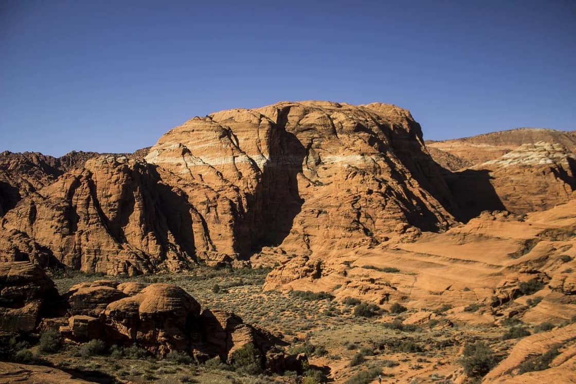
What to do. Snow Canyon State Park, on the city's northwest edge, is the classic winter walk: red and white sandstone, black lava flows and short trails. Utah State Parks lists the park's hours as 6 a.m. to 10 p.m. daily and describes winters as mild, with afternoon highs in the mid-50s. The park's page warns that temperatures drop quickly after sunset in the dry desert air, that cell coverage is limited, and that visitors should expect higher visitation and limited parking around Thanksgiving 2026. Johnson Canyon, inside the park, is closed March 15 through Sept. 14 except for ranger-guided hikes, so winter is when you can walk it on your own. Day-use passes are sold through the state's Parkspass site; check the current price there before you go, since the fetched pages did not show the dollar amount. Our full guide to Snow Canyon and St. George in winter has the trail details.
The city also has a cluster of pioneer-era sites that work in any weather; see our guide to St. George's historic sites.
Hurricane and Sand Hollow: a few degrees cooler, a lot of space
Hurricane does not have a full NOAA temperature station of its own in the 1991-2020 normals, so this guide uses the La Verkin station, just north of Hurricane at about 3,190 feet. Its normal high is 50.8 degrees in December and 52.2 in January, about two degrees below St. George, with 57.1 in February. Snow normals are under half an inch a month. Its January normal low is 29.1 degrees.
Hurricane is about 247 miles and four hours 10 minutes from Provo by OSRM, slightly closer than St. George because it sits east of the interstate on the way to Zion.
Sand Hollow State Park is the big winter draw here, for its red sand and its off-highway vehicle area. Utah State Parks lists park and visitor center hours of 7 a.m. to 9 p.m. during standard time, with shorter hours on Thanksgiving, Christmas Eve and Christmas Day. Two winter notes on the park's page: from December 2026 to February 2027, potable water may be shut off at times because of construction in the southern beach day-use areas, Beachside Campground, the cottages and Sandpit Campground, so carry your own water. And the park lists its Winter 4x4 Jamboree for Jan. 20 to 23, 2027, which will bring crowds. Check the park's fee page before you go.
Zion Canyon and Springdale: warm afternoons, a different park in winter
The Zion National Park weather station, near the south entrance at about 4,040 feet, is a surprise in the normals. Its January normal high of 53.8 degrees is essentially level with St. George, and it averages more January days at 60 or warmer (9.5) than St. George does. It is also wetter, with about 2 inches of precipitation in January and February, the most of any station here. Zion's own conditions page says winter daytime temperatures typically run from about 30 to 60 degrees.
Springdale is about 263 miles and four and a half hours from Provo by OSRM.
What's different in winter. The canyon works differently once the shuttle stops. Zion's shuttle page shows no shuttle service from Nov. 29 to Dec. 25 and says private vehicles are generally allowed on the Zion Canyon Scenic Drive in the non-shuttle season, usually December through February. Its schedule table also lists holiday shuttle service from Dec. 26 to Jan. 2, and private cars are not allowed on the scenic drive while the shuttle runs. The conditions page adds that the Park Service may close the scenic drive temporarily when parking fills.
Other winter notes from the park's conditions page:
- The park is open 24 hours a day, every day of the year.
- The Zion-Mount Carmel Highway is kept open year-round when possible, but it is sometimes closed by snow, ice, rockfall or traffic.
- Kolob Terrace Road usually closes for several months from fall to spring because of snow, starting at Maloney Hill.
- Kolob Canyons Road closes frequently in winter.
- South Campground and Lava Point Campground close in winter; Watchman Campground stays open year-round.
- Hidden Canyon is closed, and Observation Point can only be reached from the east, after a large rockfall on the East Rim Trail.
The standard private vehicle fee is $35, good for one to seven days, and the Zion annual pass is $70, according to the park's fee page. The page also lists a $100-per-person fee for non-U.S. residents 16 and older on top of the standard fee, which doesn't apply to visitors using an annual or America the Beautiful pass. For more, see our guide to what's open in Zion in winter, and for lodging tradeoffs, where to stay for Zion.
Kanab: the high-desert middle ground
Kanab sits about 4,900 feet up, the highest of these towns, and its normals show it. The January normal high is 49.4 degrees, eight degrees warmer than Provo but five below St. George. It is also the snowiest place on the list, with normals of 5.3 inches in December, 5.4 in January and 5.8 in February. That is still less than half of Provo's January normal of 12.5 inches, but it means Kanab can be white when St. George is not.
Kanab is about 269 miles and just under five hours from Provo by OSRM routing. It works best as a base for a mix of things: the Best Friends Animal Sanctuary (see our Kanab and Best Friends guide), the east side of Zion, and the drive to Page. Coral Pink Sand Dunes State Park, west of town, is open during daylight hours seven days a week, according to Utah State Parks, and lists its fees on a separate page.
Moab: dry and bright, but not warm
Moab is the closest of these towns to Provo, about 191 miles and three hours 50 minutes by OSRM, usually by US-6 over Soldier Summit and then US-191 south. It's also where expectations need the most adjusting. Its normal high is 43.9 degrees in December and 43.5 in January, barely above Provo's 41.2. Its normal lows of about 21 to 22 degrees are colder than Provo's. On average Moab sees fewer than one January day at 60 or above.
What Moab offers is dryness. Its December and January precipitation normals are 0.76 and 0.65 inches, about a third of Provo's, so many winter days are clear, cold and bright. Snow normals are small, though the December figure (4.9 inches) is higher than the other months. Spring arrives early: the March normal high is 64.6 degrees.
Arches National Park's weather page describes winter daytime highs of roughly 30 to 50 degrees and lows of roughly 0 to 20, and warns that "even small amounts of snow or ice can make local trails and roads impassable." The park is open 24 hours a day year-round, and its visitor center is open daily in winter except Dec. 25, according to its hours page, which also notes there are no ranger programs in winter.
On reservations: KSL reported on Feb. 18, 2026, that Arches would not require timed-entry reservations in 2026. When checked on Nov. 20, the park's timed-entry page said only that it was being worked on. Anyone planning a 2027 trip should check nps.gov/arch and recreation.gov. Our Moab from Provo guide covers the town itself.
Lake Powell and Page: quiet season, low water
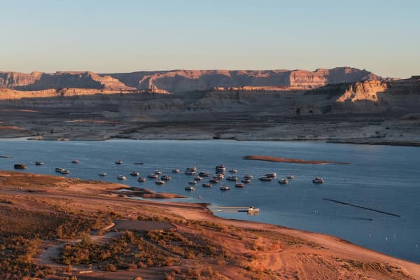
Page, Arizona, at the south end of Lake Powell, has a normal high of 43.8 degrees in December and 44.6 in January, similar to Moab. Its January normal low, 26.4, is milder than Moab's, and it is the driest station on the list, with 0.42 inches of precipitation in a normal December. Glen Canyon National Recreation Area's weather page says winters are moderately cold, with nighttime lows often below freezing, and that temperatures can drop to 0 degrees in December and January.
Page is the longest drive here, about 343 miles and six and a half hours from Provo by OSRM, routed through Kanab. From Kanab it is about 74 miles and an hour and a half.
Lake levels. The lake is low. Glen Canyon's Changing Lake Levels page, updated Nov. 19, 2026, listed Lake Powell at 3,540.47 feet on Nov. 18. On that date:
- Wahweap Main was closed to houseboats and small motorized boats and open to paddlecraft at your own risk.
- Wahweap Stateline Auxiliary was open to motorized vessels, with plate mats needed at 3,524 feet.
- Antelope Point Business ramp had limited launches arranged through Antelope Point valet services.
- Bullfrog Main was open to all vessels only above 3,578 feet, and to paddlecraft at your own risk below that.
- Halls Crossing was closed to all vessels.
What's open. The park's seasonal hours page, updated Nov. 17, 2026, lists winter hours of 9 a.m. to 4 p.m. daily at the Carl Hayden Visitor Center at Glen Canyon Dam, with dam tours closed, and 9 a.m. to 5 p.m. daily at the Navajo Bridge Interpretive Center. The Bullfrog Visitor Center is closed for winter. Glen Canyon's standard private vehicle fee is $30, and the park does not accept cash, according to its fee page.
Horseshoe Bend. The overlook is inside the recreation area, but the parking lot is on City of Page land and the city charges for parking. The Park Service says its passes do not apply to that lot. The round-trip walk is 1.5 miles on a hardened, accessible path, with railings at the overlook platform but not along the trail. Check the City of Page for the current parking rate; this guide could not confirm it from an official city page. For more on the lake, see our Lake Powell from Provo guide.
How to choose
- You want the warmest afternoons, period: St. George, or Zion Canyon if you also want the park. Both average around 54 degrees in January.
- You want warmth and fewer people: Hurricane and Sand Hollow, except during the January jamboree.
- You want the shortest drive and don't mind cold: Moab, which is dry and clear far more often than Provo in midwinter.
- You want variety, and maybe a little snow on red rock: Kanab.
- You want the quietest, emptiest version of a famous place: Page and Lake Powell, with low-water caveats.
- You're going in March: every town on the list warms sharply. The March normal high is in the 60s at all of them, from 61.8 in Page to 67.8 in St. George.
For how these parks rank against each other by drive and season, see the parent guide, the Utah national parks from Provo, ranked, and for statewide monthly weather, Utah weather by month.
Costs to plan for
This guide does not quote lodging, gas or food prices, which change too often to print. The fixed costs that come up most:
- Zion: $35 per private vehicle for one to seven days, or the $70 Zion annual pass, per the park's fee page.
- Glen Canyon: $30 per private vehicle, or the $55 Glen Canyon annual pass, per its fee page. Boat fees are separate.
- America the Beautiful pass: $80 for a resident annual pass, listed on both parks' fee pages, and it covers both.
- Utah state parks: Snow Canyon, Sand Hollow and Coral Pink Sand Dunes all charge day-use fees. Check Parkspass or each park's fee page for current amounts.
- Horseshoe Bend parking: charged by the City of Page; national park passes do not apply.
When to go
Normals favor late February and March for warmth. St. George's normal high goes from 54.0 degrees in January to 59.3 in February and 67.8 in March, and the number of 60-plus days roughly doubles from January to February. December and January are the coldest and, in the southwest corner, the quietest, apart from the holidays.
Holiday weeks are an exception. Zion's holiday shuttle runs Dec. 26 to Jan. 2, Snow Canyon warns of heavy Thanksgiving crowds, and winter break brings Utah families south at the same time. If you can go midweek in January or early February, the parks are calmer, though days are short and nights are cold.
What to bring
- Layers. Every town on this list has a normal January low below freezing. A 55-degree afternoon can be a 28-degree evening.
- Traction for the car, and know the law. The drive crosses high country on I-15 and US-6.
- Microspikes for trails in Moab, Kanab and Zion after a storm. Arches warns that small amounts of ice can make trails impassable.
- Water. Sand Hollow's potable water may be off at times this winter, and Snow Canyon says to carry your own.
- Sun protection. Snow Canyon's page notes winter sun can still burn.
- A paper map or offline maps. Snow Canyon notes limited cell coverage, and the same is true of much of the backcountry here.
- A headlamp. Days are short in December and January.
Safety and conditions
The drive is the biggest risk. A sunny forecast in St. George or Moab says nothing about Soldier Summit or the high stretches of I-15. Check UDOT's traffic site or app before you leave and again at stops. Our guide to Utah road conditions and where to check them lists the sources.
Cold nights. Even in St. George, a normal January has about 20 nights below freezing. Camping in winter means a sleeping bag rated well below freezing.
Ice on trails. Shaded slickrock and canyon bottoms hold ice long after a storm. In Zion, also watch for rockfall closures, which the park lists on its conditions page.
Rain in narrow canyons. Before entering a slot or narrow canyon in any season, check the National Weather Service forecast for that specific area and ask at the nearest visitor center.
Water safety at Lake Powell. The Park Service's conditions page lists a recreational water advisory for Lake Powell beaches and waters. Check it before swimming or wading.
What to check before you go
- The actual forecast from the National Weather Service at weather.gov for the town you're visiting, not just the normals in this guide.
- UDOT road conditions for I-15, US-6 and US-89.
- Zion's conditions and shuttle pages for road closures and the holiday shuttle.
- Arches' reservation page if your trip runs into 2027.
- Glen Canyon's Changing Lake Levels page for ramp status if you plan to boat.
- State park fee pages and Parkspass for current day-use prices.
- The City of Page for Horseshoe Bend parking.
- Air quality at home. If an inversion is building in Utah Valley, that's your window to leave while roads are dry.
About the numbers
The temperature, precipitation and snowfall figures in this guide are NOAA's 1991-2020 monthly climate normals, downloaded from the National Centers for Environmental Information on Nov. 20, 2026, for these stations: St. George, La Verkin (for Hurricane), Zion NP, Kanab, Moab, Page, Ariz., and Provo BYU. Elevations are the station elevations NOAA lists, converted from meters and rounded. Normals describe a 30-year average. A single winter can be far from normal in either direction.
Frequently Asked Questions
What is the warmest place in Utah in winter?
Is Moab warm in winter?
How warm is Lake Powell in winter?
How long is the drive from Provo to St. George?
Can I drive my own car through Zion Canyon in winter?
Does Arches National Park need a timed entry reservation this winter?
Can I boat on Lake Powell in winter?
Does it snow in St. George?
Sources
The facts in this guide were checked against these sources. Hours, fees and rules change, so confirm anything time-sensitive with the source before you go. How we make Provo.com.
- U.S. Climate Normals 1991-2020, monthly normals (St. George, La Verkin, Zion NP, Kanab, Moab, Page, Provo BYU), NOAA National Centers for Environmental Information. Checked November 20, 2026.
- Zion National Park: Current Conditions, National Park Service. Checked November 20, 2026.
- Zion Canyon Shuttle System, National Park Service. Checked November 20, 2026.
- Zion National Park: Fees and Passes, National Park Service. Checked November 20, 2026.
- Arches National Park: Weather, National Park Service. Checked November 20, 2026.
- Arches National Park: Operating Hours and Seasons, National Park Service. Checked November 20, 2026.
- Glen Canyon NRA: Changing Lake Levels, National Park Service. Checked November 20, 2026.
- Glen Canyon NRA: Seasonal Hours, National Park Service. Checked November 20, 2026.
- Glen Canyon NRA: Fees and Passes, National Park Service. Checked November 20, 2026.
- Glen Canyon NRA: Weather, National Park Service. Checked November 20, 2026.
- Horseshoe Bend, National Park Service. Checked November 20, 2026.
- Snow Canyon State Park, Utah State Parks. Checked November 20, 2026.
- Sand Hollow State Park, Utah State Parks. Checked November 20, 2026.
- Coral Pink Sand Dunes State Park, Utah State Parks. Checked November 20, 2026.
- OSRM routing (OpenStreetMap) drive distances from Provo, Project OSRM. Checked November 20, 2026.
- Arches drops timed-entry program amid pressure from Grand County leaders, KSL.com. Checked November 20, 2026.
- Smog covers parts of northern Utah as inversion season begins, KSL.com. Checked November 20, 2026.