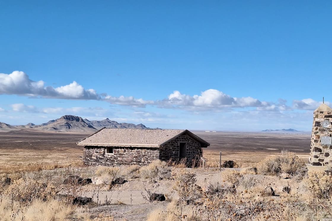
The Pony Express lasted about a year and a half, and in Utah its route still runs where it ran in 1860: west from Salt Lake City, across Cedar Valley, over the Onaqui Mountains and out across the West Desert to the Nevada line. Much of that line is now a gravel road the Bureau of Land Management maintains as the Pony Express National Backcountry Byway. The BLM describes the landscape along it as "virtually unchanged from the days of the Pony Express rider."
This guide is a map-based tour of that road, built from what the BLM, the National Park Service, Utah State Parks, the Utah Historical Society and the U.S. Fish and Wildlife Service publish about each stop. It covers what was at each station, what is there now (often a monument, sometimes ruins, once a replica), and how to drive it from Provo safely, especially in November. For the longer story of the valley this trip starts from, see our short history of Provo.
Quick facts
| Item | Detail | Source |
|---|---|---|
| Years of operation | April 1860 to October 1861, about 18 months | NPS |
| Official end | Oct. 26, 1861 | NPS |
| Utah stations (present state) | 27 stations over 263 miles of trail | NPS |
| Byway road surface | Maintained gravel | BLM |
| Byway access from Utah Valley | I-15 Exit 279 (Lehi), SR-73 west 25 miles | BLM |
| Byway fee | None | BLM |
| Simpson Springs Campground | 20 sites, open year-round, $15 a night | BLM |
| Camp Floyd State Park Museum | Monday to Saturday, 9 a.m. to 5 p.m. | Utah State Parks |
| Fish Springs refuge | Free, sunrise to sunset, every day of the year | USFWS |
| Nearest services to Fish Springs | 75 miles | USFWS |
| Provo to Fairfield | About 36 miles, about 47 minutes (routing estimate, no traffic) | OSRM |
A short history: 18 months, 10 days
The Pony Express carried mail by relays of riders between St. Joseph, Missouri, and Sacramento, California. The National Park Service describes it as "the most direct and practical means of east-west communications before the telegraph," and gives the target as 10 days for a route of more than 1,800 miles. Utah Humanities puts the route at roughly 2,000 miles, and a 1995 History Blazer article published by the Utah Historical Society on its History To Go site uses 1,966.
The Utah History Encyclopedia entry by Jay M. Haymond dates the start to April 3, 1860, and says Russell, Majors and Waddell ran the service, with stations 10 to 15 miles apart. Haymond writes that the company lost about $500,000; the BLM says the service never made a profit.
Utah's role starts before the first rider. The History Blazer article argues that the Utah War of 1857-58 "led indirectly to the establishment of the Pony Express": Russell, Majors and Waddell lost equipment and livestock in that conflict, and Russell proposed the mail service partly to save the company. The federal army sent to Utah built Camp Floyd in Cedar Valley, which became a station on the route. Our guide to the Utah War and Camp Floyd covers that conflict in full.
The route across the West Desert also has a Camp Floyd origin. The NPS says Capt. James H. Simpson, a topographical engineer from the camp, stopped at what became Simpson Springs in 1858 while laying out an overland mail route between Salt Lake City and California. George Chorpenning set up a mail station there that year, and the Pony Express and Overland Stage used it later.
Salt Lake City was a hinge on the line. Haymond lists the Salt Lake House at 143 South Main as the city's station, and the NPS station list marks it as a home station. Utah operations ran under Maj. Howard Egan of the Nauvoo Legion, and Haymond writes that they ran "rather smoothly." He adds that Utah companies supplied many of the horses. The NPS says Egan, as division superintendent, oversaw stations between Salt Lake City and Roberts Creek, Nevada, and ran a ranch and home station at Deep Creek, near present-day Ibapah. The History Blazer article says two of his sons also rode for the Pony Express.
The end came through Salt Lake City too. According to the History Blazer article, "In October 1861 the Pacific Telegraph was completed at Salt Lake City," and the Pony Express became obsolete. The NPS gives Oct. 26, 1861, as the official termination.
How many stations? Three honest answers
You will see different station counts for Utah, and each is correct on its own terms.
- 27 stations over 263 miles. An NPS article on Utah's stations, drawing on a U.S. Senate document from the 46th Congress on the Overland Mail contract and a 2010 National Pony Express Association map, lists 27 within the present state, from Needle Rock in the east to Deep Creek at Ibapah.
- 20 of 190. Haymond's encyclopedia entry counts 20 Utah stations out of 190 on the whole route.
- About 65 of 190. A BLM cultural resource study, The Pony Express Stations of Utah in Historical Perspective by Richard E. Fike and John W. Headley, counts the stations within Utah Territory as it stood in 1860, from Pacific Springs, Wyoming, to the California border.
Station names vary too; the NPS list gives most stations several alternate names. This guide uses the names on the BLM and NPS site pages.
The stations you can visit, east to west from Cedar Valley
The stops below run from Cedar Valley to the Nevada line, with mileages from the NPS site pages and the BLM study.
Camp Floyd and the Stagecoach Inn, Fairfield
This is the most substantial stop and the only one with a building you can walk into. The NPS says Camp Floyd was established in 1858, was "the first military installation built in present-day Utah," and became the territory's third-largest community. During the Pony Express era, its troops helped keep the trail open for the Pony Express, the stage lines and other travelers.
The Pony Express station itself, according to the NPS, was "a small adobe building that stood several hundred feet northeast of John Carson's Inn," and it has disappeared. The inn still stands, restored, as the centerpiece of Camp Floyd State Park Museum. The NPS says the camp's commissary building serves as the visitor center and that an interpretive wayside exhibit sits in the picnic area. Utah State Parks says the park has three structures and a cemetery.
The NPS lists the park address as 18035 West 1540 North, Fairfield. Hours and fees are below. Our Cedar Fort and Fairfield guide covers the town and the camp in more depth.
Faust (Rush Valley)
The NPS lists this home station as Bush Valley, Rush Valley, Meadow Creek or Faust. From Fairfield, the NPS directions run west on UT-73 for 5 miles, then left on East Faust Road for 13.6 miles to UT-36, where the Faust Pony Express Station monument stands. The BLM byway map says the station, named for station keeper "Doc" Faust, was a two-story stone structure located some distance from the present marker.
Lookout Pass and Point Lookout
From the Faust monument, the NPS says to turn left on UT-36 for about half a mile, turn right onto Pony Express Road and drive 8.4 miles to Lookout Pass, then 0.7 mile more to the station site. Point Lookout is about 28 miles southwest of Fairfield.
The NPS says the station, a two-room log cabin, was mentioned by a traveler on April 15, 1860, and was a ruin by September, possibly destroyed by Paiute warriors during the Pyramid Lake War. An old stone monument stands by the road, and a silver-colored steel fencepost marks the station site 30 yards northeast of it.
Across the road is a stone and concrete enclosure that the NPS says protects the graves of homesteader Libby Rockwell's pet terriers and, reportedly, three emigrants who died on the trail. It is the only structure standing at Point Lookout.
Government Creek
The BLM study places Government Creek, also called Davis Station, eight miles from Point Lookout and reports that "the foundations of two structures remain evident at the site."
Simpson Springs
Simpson Springs is the stop most people picture when they think of the Utah trail. The NPS says its "excellent water" made it one of the most prominent stations in the West Desert, and that it is not known for certain which of the many structures built there over the years served the Pony Express.
The one-room stone building at the site is a replica, built in 1975 by the Future Farmers of America under BLM direction, according to the NPS. A monument marking the station site went up in 1965. The BLM says the site also held a Civilian Conservation Corps camp in the late 1930s and early 1940s. Across the road from the campground, the BLM's interpretive site has shade-covered kiosks and a plaque in front of the replica. The paths to them are uneven natural surfaces.
The NPS and BLM both put Simpson Springs about 25 miles west of SR-36 on maintained gravel.
Riverbed, Dugway and Blackrock
These three are marker stops. The BLM study places Riverbed eight miles past Simpson Springs and says little remains because of flash flooding; a monument there was placed by the CCC in 1939 or 1940. Dugway, 10.5 miles farther, has a monument and a disturbed area with scattered metal and stone. At Blackrock, 13.75 miles past Dugway, the study's authors write that they "have not located the site," and a vandalized monument marks the general location. Those are trail miles from the study, not road odometer readings.
The road between Simpson Springs and Fish Springs passes near Dugway Proving Ground. If you want to stop and dig on this stretch, our Dugway Geode Beds guide covers the beds just off the road.
Fish Springs
The NPS says Capt. Simpson's survey team established a mail station here in 1859, at what was the most abundant water between Camp Floyd and Deep Creek. It served the Pony Express, the Overland Stage and later the telegraph.
The original station was a simple stone building near House Spring, about a mile from the refuge entrance. Only "a scattering of small debris" remains, and a silver-colored fencepost marks the spot. A CCC stone monument from the 1930s stands less than a mile northwest of the refuge entrance beside Pony Express Road.
From Simpson Springs, the NPS route runs southwest on Simpson Springs-Callao Road for about 31 miles, where the road becomes Pony Express Road again, then 10.6 miles to the refuge turn. Inside the refuge, the NPS says the station site is across the road from a shaded picnic area on the Harrison Pool loop. The NPS gives the station site at 39.8501, -113.3964.
The station sits inside Fish Springs National Wildlife Refuge, a spring-fed wetland the NPS puts at 10,000 acres on the south edge of the Great Salt Lake Desert. The Fish and Wildlife Service says the refuge is free and open sunrise to sunset every day, and that the auto tour route is open during daylight. As of today, the refuge's page says public bathrooms and drinking water are unavailable "until further notice."
Boyd Station
Boyd is the best ruin on the Utah route. The NPS calls it "one of the best-preserved express stations in Utah," a stone building with defensive gunports that became a relay station in 1860. Its namesake, George Washington "Bid" Boyd, is said to have lived there until around 1900, which the NPS suggests is why nobody hauled the stone away.
The ruins stand on their original spot with a BLM kiosk nearby. The NPS says Boyd is 14 trail miles, or 8 miles straight-line, west of Fish Springs. Drive 14 miles from the refuge, keep right where Granite Ranch Road splits off, and look for the site on the north side of the road.
Willow Springs, Callao
The NPS says local tradition places the Willow Springs station on Willow Springs Ranch in Callao, where a wood-clad adobe building at ranch headquarters is "believed to be the original Willow Creek Pony Express station," next to a cottonwood from the Pony Express era. The ranch is private, and the NPS says owners' permission is required to visit the station. A 1939 monument at the ranch entrance on East Pony Express Road is open to the public. Callao is 25 miles west of Fish Springs, according to the NPS.
Canyon Station (Burnt Station and Round Station)
The NPS says Howard Egan chose the site in Overland Canyon in the Deep Creek Mountains and built the station in 1861. It was dry, so water was hauled from Deep Creek, 8 miles west. The Pony Express used it until October 1861 and the Overland Stage for two more years.
On Aug. 8, 1863, the NPS says, Goshute warriors attacked in retaliation for soldiers destroying a Goshute village, killed at least five Overland Stage employees and soldiers, and burned the station. Within months the stage company rebuilt about 3.5 miles southeast at the other end of the canyon. That rebuilt site, Round Station, is now a BLM interpretive stop with a low, circular stone wall with gunports. The BLM byway map says stone outlines of the 1863 station are still visible.
From Willow Springs, the NPS directions run northwest on Pony Express/Deep Creek Mountains Road about 13 miles to the Round Station entrance on the left. The Burnt Station monument is 3.5 miles farther, across a dry wash, reached on two-track roads.
Deep Creek, Ibapah
The last Utah station was Egan's ranch and home station on Deep Creek, in the homeland of the Goshute people. The NPS says a telegraph repeater station replaced the Pony Express operation there after October 1861. The original buildings are gone. An interpretive monument stands at the center of Ibapah in front of the elementary school, and a 1934 limestone monument is 0.7 mile south on Willow Road. The NPS lists the site as private.
The BLM byway and its map
The BLM manages the Utah route as the Pony Express National Historic Trail Backcountry Byway, out of its Salt Lake Field Office. The BLM page offers three planning tools: a dynamic ArcGIS map, a downloadable PDF byway map and a Flickr album titled "Pony Express Auto Tour." The PDF is geo-referenced, which means a map app that reads geo-referenced PDFs can show your position on it without cell service.
The BLM charges no fee to drive the byway. Its PDF map asks visitors to treat station sites with care: moving or taking artifacts, "including historic trash," from public lands violates federal law.
The BLM field office can be reached at 801-977-4300 or blm_ut_sl_mail@blm.gov.
Driving it from Provo
To Cedar Valley. The BLM's directions from Utah Valley are I-15 to Exit 279 at Lehi, then west on SR-73 for 25 miles, then west onto the byway. SR-73 is the road through Cedar Valley past Eagle Mountain to Cedar Fort and Fairfield. Provo to Fairfield is about 36 miles and 47 minutes by an OpenStreetMap routing estimate that assumes no traffic. Camp Floyd is the natural first stop.
Onto the gravel. The station entries above give the NPS mileages: Fairfield to Faust is about 18.6 miles, Simpson Springs is about 25 miles of gravel past SR-36, and the Fish Springs turn is roughly 42 miles beyond that. The Fish and Wildlife Service puts Fish Springs about three hours from Salt Lake City via the Pony Express route and says an approach from the east involves about 80 miles of gravel.
A sensible day from Provo is Camp Floyd, Faust, Lookout Pass and Simpson Springs, then back the way you came. Fish Springs and Boyd make a long day. Callao, Canyon Station and Ibapah are an overnight trip, with camping at Simpson Springs.
Mind the GPS. The Fish and Wildlife Service warns that GPS units may route drivers onto poorly maintained roads or into secure military areas, and that some travelers have spent nights in their vehicles after getting stuck. Stay on the signed byway.
Road conditions and safety
- Gravel, not pavement. The BLM maintains the road, but the Fish and Wildlife Service warns that the gravel can be "very slippery" and has corrugations and potholes "that can cause you to run off the road." It says single-car rollovers are the leading cause of vehicle injury and death in the West Desert. Drive slower than the road invites.
- No services. The nearest town with services is 75 miles from Fish Springs. The Fish and Wildlife Service lists gas at Lynndyl, Delta, the Border Inn on U.S. 6, Wendover and Stockton. Fill up in Lehi or Eagle Mountain before you leave Cedar Valley.
- Tires. The Fish and Wildlife Service tells visitors to carry a spare, a patch kit and a portable air compressor. The NPS's general trail safety page says to make sure tires are in good shape and your vehicle suits the surface.
- Water. The refuge recommends 2 liters to 1 gallon per person per day. Water at Simpson Springs is seasonal, and drinking water at Fish Springs is unavailable for now, so bring all you need.
- Cell coverage. The refuge says phones do not work for many miles in any direction around Fish Springs. Download maps and tell someone your route and return time.
- Off-road travel. The refuge does not allow off-road vehicles. Wilson Hot Springs, near the refuge, is on U.S. Army property; the refuge warns that dogs have died from burns there and that vehicles get stuck in the spring water crossing the road.
Seasons, and what November means
The byway has no posted closure season on the BLM page, and Simpson Springs Campground is open year-round. Winter changes the trip, though. The Fish and Wildlife Service tells visitors to pack warm clothing and sleeping bags for cold weather and notes that snow drifts have stranded travelers. The NPS safety page says weather can change rapidly.
In mid-November, plan around short days. The refuge closes at sunset, and the gravel is no place to be learning the road in the dark. Leave Provo early, check the sunset time before you go, and set a turnaround time you will keep. Before a winter drive, call the BLM Salt Lake Field Office about conditions.
Hunting is on the BLM's list of byway activities, so other vehicles and people on foot may be out on the desert in season.
Camp Floyd State Park Museum stays on its Monday-to-Saturday schedule in November but closes on Thanksgiving, which falls on Nov. 26 this year.
Hours and fees
- Camp Floyd State Park Museum: Monday to Saturday, 9 a.m. to 5 p.m., closed Thanksgiving, Christmas and New Year's Day, per the Utah State Parks page as posted today. The park page links to a separate fee page and day passes, but this reporter could not confirm current admission amounts from a page fetched today. Call 801-768-8932 or check stateparks.utah.gov before you go.
- Pony Express Backcountry Byway: No fee, per the BLM.
- Simpson Springs Campground: $15 per site per night, year-round, reservations through recreation.gov, per the BLM. The BLM lists vault restrooms and seasonal drinking water, and no shade at the sites.
- Fish Springs National Wildlife Refuge: Free, sunrise to sunset, 365 days a year, per the Fish and Wildlife Service.
What to bring
- A full tank, a full-size spare, a patch kit and a portable air compressor.
- At least 2 liters to 1 gallon of water per person per day.
- Food that does not need a cooler.
- Warm layers and sleeping bags from fall through spring, even on a day trip.
- Downloaded offline maps, the BLM's PDF byway map and the NPS station GPS points.
- Sturdy shoes; the paths at Simpson Springs and the two-tracks near Canyon Station are uneven.
Who should skip it
- Anyone expecting a reconstructed fort. Outside Camp Floyd, Boyd and Round Station, most stops are monuments, fenceposts and a view. The draw is the country itself.
- Drivers without a good spare. The gravel is long and help is far.
- Anyone planning to visit Willow Springs' original building without asking. It is on a private ranch.
- Dog owners who want to let pets loose near Wilson Hot Springs. The refuge's warning about burns is specific.
For a shorter version, Camp Floyd, the Faust monument and Lookout Pass make a half-day from Provo. Only the last 8.4 miles to Lookout Pass are on Pony Express Road gravel.
The Eagle Mountain connection
Eagle Mountain's summer festival takes its name from this trail. The city's page says Pony Express Days is "named for the Pony Express Trail" and "is a celebration of the Cedar Valley and its rich history." The festival's venues carry the name too: the Pony Express Memorial Cemetery hosts its Memorial Day ceremony and the Pony Express Memorial Arena its demolition derby and PRCA rodeo. Our Pony Express Days guide covers how the three weekends fit together.
The city's page says 2027 dates are still to be announced. When they are, a festival weekend pairs well with the short version of this drive. For how Eagle Mountain grew up on former Cedar Valley rangeland, see our short history of Saratoga Springs and Eagle Mountain.
Sources: the Bureau of Land Management (byway, trail and Simpson Springs pages, the Utah byway map and the Fike and Headley station study), the National Park Service (Pony Express National Historic Trail pages and Utah station site pages), Utah State Parks, the Utah Historical Society's History To Go, Utah Humanities, the U.S. Fish and Wildlife Service and Eagle Mountain City. All pages checked Nov. 12, 2026.
Related Guides
- A Short History of Provo: From Fishing Camp to College Town
- Pony Express Days: The Celebration That Spreads Across Three Weekends
- The Utah War of 1857-58: Johnston's Army, the Move South and Camp Floyd
- Cedar Fort & Fairfield: Camp Floyd and Utah County's West Desert Edge
- Dugway Geode Beds from Provo
- Things to Do in Tooele and the West Desert, From Provo
- Topaz: Utah's Japanese American Internment Camp and the Museum in Delta
Frequently Asked Questions
When did the Pony Express run through Utah?
How many Pony Express stations were in Utah?
Where does the Pony Express road start near Utah Valley?
Is the Pony Express Trail road paved?
Can you camp on the Pony Express Trail in Utah?
Is there cell service on the Pony Express road?
Which Pony Express station in Utah is best preserved?
How is Eagle Mountain's Pony Express Days connected to the trail?
Sources
The facts in this guide were checked against these sources. Hours, fees and rules change, so confirm anything time-sensitive with the source before you go. How we make Provo.com.
- Pony Express National Historic Trail (Utah), Bureau of Land Management. Checked November 12, 2026.
- Pony Express Back Country Byway, Bureau of Land Management. Checked November 12, 2026.
- Simpson Springs Campground, Bureau of Land Management. Checked November 12, 2026.
- Utah Pony Express National Backcountry Byway Map, Bureau of Land Management. Checked November 12, 2026.
- The Pony Express Stations of Utah in Historical Perspective (Fike and Headley), Bureau of Land Management (hosted by NPS History). Checked November 12, 2026.
- Pony Express National Historic Trail, National Park Service. Checked November 12, 2026.
- History and Culture, Pony Express NHT, National Park Service. Checked November 12, 2026.
- Utah Pony Express Stations, National Park Service. Checked November 12, 2026.
- Camp Floyd/Stagecoach Inn State Park, National Park Service. Checked November 12, 2026.
- Point Lookout Station, National Park Service. Checked November 12, 2026.
- Simpson Springs Station, National Park Service. Checked November 12, 2026.
- National Park Service: Fish Springs, National Park Service. Checked November 12, 2026.
- National Park Service: Boyd Station, National Park Service. Checked November 12, 2026.
- Willow Springs Station, National Park Service. Checked November 12, 2026.
- Canyon Station, National Park Service. Checked November 12, 2026.
- Deep Creek Station, National Park Service. Checked November 12, 2026.
- Safety, Pony Express NHT, National Park Service. Checked November 12, 2026.
- Camp Floyd State Park Museum, Utah State Parks. Checked November 12, 2026.
- Pony Express in Utah (Jay M. Haymond, Utah History Encyclopedia), Utah Historical Society, History To Go. Checked November 12, 2026.
- The Pony Express Added a Colorful Chapter in Utah History (Jeffrey D. Nichols, History Blazer), Utah Historical Society, History To Go. Checked November 12, 2026.
- Fish Springs National Wildlife Refuge, U.S. Fish and Wildlife Service. Checked November 12, 2026.
- The Pony Express in Utah, Utah Humanities. Checked November 12, 2026.
- Pony Express Days, Eagle Mountain City. Checked November 12, 2026.