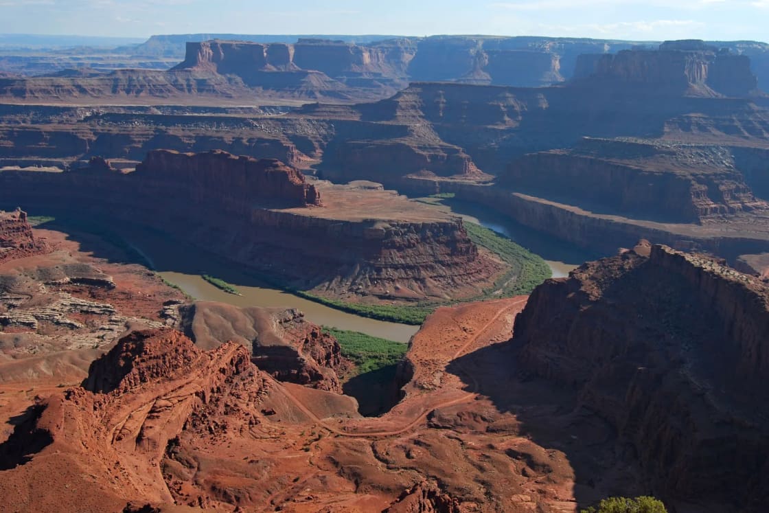
Dead Horse Point State Park is the overlook people mean when they say Moab has one view you have to see. It sits at the end of State Route 313 on the same mesa as Canyonlands National Park's Island in the Sky district, and the main viewpoint is a 200-foot paved walk from a parking lot. From the rail, Utah State Parks says, the Colorado River runs roughly 2,000 feet below. The park is open 6 a.m. to 10 p.m. year-round, costs $20 per private vehicle and is run by the state, not the National Park Service, which means your national park pass does not get you in. This guide covers the drive from Provo, the fees, the overlook, the rim trails, the Intrepid mountain bike system, camping and yurts, the night sky and how to fit the park into a trip with Arches and Canyonlands.
For the bigger trip, start with our Moab from Provo guide. This page is the detail on one stop.
| Item | Detail | Source |
|---|---|---|
| Managing agency | Utah State Parks | Utah State Parks |
| Park hours | 6 a.m. to 10 p.m., year-round | Utah State Parks |
| Visitor center | 7 a.m. to 5 p.m. on the website; 9 a.m. to 5 p.m. in the brochure | Park website, brochure |
| Holiday closures | Visitor center closed Thanksgiving, Christmas, New Year's Day | Utah State Parks |
| Vehicle fee | $20, up to 8 people | Park fee page |
| National park passes | Not accepted | Moab Area Travel Council |
| Main overlook | 200 feet one way, paved | Park hiking page |
| Rim trails | About 7 miles linking 9 overlooks | Park hiking page |
| Elevation | 5,900 feet | Park history page |
| From Provo | About 198 miles, a little over 4 hours | OSRM estimate |
| From Moab | 32 miles | Park brochure |
| Phone | 435-259-2614 | Utah State Parks |
The drive from Provo
An OpenStreetMap routing estimate (OSRM) puts Dead Horse Point about 198 miles from downtown Provo, a little over four hours without stops. Most of that is the drive our Moab guide describes: I-15 south to Spanish Fork, US-6 southeast through Spanish Fork Canyon and Price, east on I-70 past Green River, then south on US-191 toward Moab.
The difference from a Moab trip is that you never reach town. SR-313 leaves US-191 north of Moab, and the park brochure gives the location as nine miles north of Moab on US-191, then 23 miles south on SR-313 at the end of the highway. Coming from Provo, that is a right turn off US-191 before you drop to the Colorado River. The National Park Service describes the same turn for Island in the Sky, about 10 miles north of Moab, and says the park road runs about 22 miles southwest from there. The OSRM route spends its last 4.5 miles on the state park road after leaving the SR-313 scenic byway, so watch the signs for Dead Horse Point rather than Canyonlands. The Park Service also warns that a navigation system may send you the wrong way, so carry a paper or downloaded map.
From town, the Moab Area Travel Council lists the park at 30 miles and about 37 minutes, and the brochure says 32 miles. Either way, plan on a full Provo-to-park drive of more than four hours, which makes Dead Horse Point part of an overnight Moab trip rather than a day trip from Utah Valley.
Two practical road notes. First, fill the tank in Green River or Moab: the brochure says gas, food and medical care are in Moab, 32 miles away. Second, check UDOT's traffic site, udottraffic.utah.gov, before you leave. It shows incidents, construction, cameras and color-coded road weather, and its current-conditions reports for road segments run November through April. Our road conditions guide covers how to read it for US-6.
Fees and passes
The park's fee page lists these day-use rates:
- Private vehicle, up to 8 people: $20. "Entry reservations not required," the page says.
- Each person beyond 8 in a high-capacity vehicle: $2.
- Utah residents 65 and older: $15 per vehicle.
- Motorcycle: $10.
- Bike-in or walk-in: $10 per group of four cyclists or hikers, with the vehicle parked outside the park.
- Commercial vehicles: $5 per person, valid on the date of purchase only.
The fee page says day-use fees can be paid online or on arrival, and it adds that the park does not honor rates posted on other websites. The park's mixed-use trails page says the per-vehicle day-use fee is valid for two consecutive days; the fee page does not repeat that, so keep your receipt and confirm at the entrance if you plan to come back the next morning.
Your national park pass does not apply. This is the point that trips up most Utah Valley visitors on a Moab weekend. The Moab Area Travel Council says national park passes are not accepted at Dead Horse Point because it is a state park. Canyonlands' fee page, last updated April 18, 2025, lists $30 per private vehicle, the $55 Southeast Utah annual pass covering Arches, Canyonlands, Natural Bridges and Hovenweep, and the $80 America the Beautiful resident annual pass. None of those cover the state park. Our national park passes guide explains the federal side, and our who manages what guide explains why the two systems do not overlap.
The Utah State Parks annual pass does. Dead Horse Point's fee page lists annual permits of $125 for Utah residents under 65 and $65 for residents 65 and older. The statewide passes page says the pass covers day-use entry for the cardholder and up to seven guests in the same private vehicle for 12 months, at all 46 Utah state parks except Jordan River OHV State Park and This is the Place Heritage Park. It is sold only to Utah residents, online at parkspass.utah.gov and at staffed state park visitor centers. It does not cover camping. If your family already plans a summer at Utah Lake State Park and a Goblin Valley trip, the math can favor the annual pass; at $20 a visit, six or more vehicle entries a year pass $125.
The same page describes a free Veterans with Disabilities Honor Pass for Utah residents who were honorably discharged and have a documented service-connected disability, covering the veteran and up to seven guests in one vehicle.
The overlook
The Overlook Trail, as Utah State Parks calls it, is the reason most people come. The park rates it easy, 200 feet one way from the overlook parking lot, on a short paved path built to ADA standards. It ends at a large shelter with views of the Colorado River about 2,000 feet below. The Moab Area Travel Council calls the scene "one of the most photographed scenic vistas in the world," and says the overlooks also show backcountry roads into Canyonlands and both past and present mining, including the potash ponds.
The name comes from a legend the park tells in its history page and brochure. Around the turn of the 20th century, cowboys used the point as a corral for wild mustangs, herding them across a neck of land "only 30 yards wide" and fencing it with branches and brush. They kept the horses they wanted and, according to the legend, left the others on the waterless point, where they died of thirst within sight of the river. The park opened to the public in 1959 and sits at 5,900 feet, according to the history page.
Paved paths run east and west from the shelter and link to the rim trail systems. The hiking page warns that the east and west spurs have steeper grades and short sections of slickrock and that those paved sections are not ADA accessible. If someone in your group uses a wheelchair or stroller, the main path to the shelter is the stretch the park describes as accessible.
The Moab Area Travel Council's suggested short visit is to drive the main park road and walk to the main overlook, which it estimates at about half a day. With the drive from Moab and back, that is about right.
The rim trails
The park describes about seven miles of rim trails connecting nine overlooks. They are primitive trails marked with cairns, rock lines and wood, and the park asks visitors not to move the rocks or wood and not to build or knock down cairns. Here is what the hiking page lists:
- Visitor Center Nature Trail. Easy, one-eighth mile one way on a paved path outside the visitor center, with views of the basin to the east, the La Sal Mountains and Chimney Rock. Eight trailside exhibits cover desert plants, and a sign explains the solar evaporation ponds used for potash and salt mining. This is the short walk for small children while someone waits in the gift shop line.
- Desert View Overlook. Easy, half a mile one way, heading north from the visitor center along the east rim to views of the canyon bottom, the river and the potash ponds. The park notes potholes that can hold fairy shrimp and juniper groves where you might see rabbits, lizards, mule deer and possibly bighorn sheep.
- East Rim Trail. Easy, 1.5 miles one way between the visitor center and Dead Horse Point, mostly flat except a short hill about a quarter mile from the visitor center. The Basin Overlook spur adds half a mile and drops about 100 feet to a shelf with quieter canyon views.
- West Rim Trail. Moderate, 2.5 to 3.5 miles one way, crossing the road from the visitor center and passing through the campground. The park calls it the longest hiking trail in the park, more primitive and less traveled than the East Rim. The Meander, Shafer and Rim overlook spurs add about a mile and look into Shafer Canyon.
- Bighorn Overlook Trail. Moderate, 1.5 miles one way, branching north near Kayenta Campground off the West Rim. The park says its views rival those at Dead Horse Point and names the overlook for an eroded fin that looks like a pair of horns. It warns of short sections of moderate cliff exposure and says the overlook has "no guardrails."
The East Rim and West Rim together form a loop of 5 miles or more that starts and ends at the visitor center, which the park describes as a half-day hike. For a family with older kids, the simplest good plan is the East Rim one way to the point, then a ride back if someone in the group can shuttle the car. For a student group with a free morning, the full loop gets you most of the park's overlooks on foot.
The park's hiking page says sturdy footwear is "highly recommended" because of uneven slickrock, and that bikes are not allowed on hiking trails, as the brochure also says.
The Intrepid mountain bike trail system
The singletrack at Dead Horse Point is the Intrepid Trail System. The park's mixed-use trails page lists the trails, which it says generally run as a counterclockwise loop, with difficulty ratings that apply only within this system:
| Trail | Distance and time | Park rating |
|---|---|---|
| Intrepid | 0.5 mile, 4 to 5 min | Easy |
| Raven Roll | 1.7 miles, 8 to 12 min | Easy |
| Great Pyramid | 2.2 miles, 20 to 25 min | Easy to moderate |
| Big Chief | 3.6 miles, 32 to 38 min | Easy to moderate |
| Crossroads | 1.7 miles, 11 to 15 min | Easy to moderate |
| Whiptail | 2.6 miles, 22 to 26 min | Moderate |
| Twisted Tree | 1.5 miles, 15 to 18 min | Moderate to difficult |
| Prickly | 2.2 miles, 24 to 26 min | Moderate to difficult |
| Pair | 1.8 miles, 16 to 18 min | Moderate to difficult |
The page suggests two loops. Raven Roll plus Great Pyramid is about 4 miles and easy, and Raven Roll plus Big Chief is about 8 miles and moderate. Big Chief has a 0.7-mile spur to Miner's Point. The Moab Area Travel Council lists a 14.4-mile Dead Horse Point tour loop and describes the system as beginner-friendly singletrack, mostly flat with moderate climbing, open year-round and cooler in summer than other Moab systems because of its elevation.
The main trailhead is one mile south of the entrance station. A secondary trailhead on the north side of the visitor center lot is for use only when the main lot is full. Riders must dismount to cross the park road.
Read the park's warnings before you pick a loop:
- Treat everything as difficult. The mixed-use page says the trails are not specifically maintained for mountain bikes and should all be treated as difficult, with scattered obstacles.
- Washouts. The park's current conditions page says recent washouts have made some trails harder than the park map shows, and names the Big Chief loop. That page also carries a "last updated" date of Sept. 9, 2026, so call the visitor center for a fresher report.
- Remoteness. The page calls this the park's most remote section, says basic route-finding skills are needed and says cell reception on the far east rim is "spotty at best."
- Hikers share the trail. The trails are mixed-use, and the page tells hikers to expect bikes. The hiking page separately describes a mixed-use system of nearly six miles along the far east rim with seven overlooks, which it calls new in 2025.
E-bikes. The brochure says bikes and e-bikes are allowed on established public roads and in parking areas, and that singletrack riding is available on the Intrepid system. The Moab Area Travel Council lists e-biking as a use of the Intrepid system. The park's mixed-use page does not mention e-bikes, so confirm with the visitor center before you bring one onto the singletrack.
Rentals. The park page says Bighorn Rentals operates at the mountain bike trailhead with tours and rentals and recommends reservations. The Moab Area Travel Council calls that rental company seasonal and notes that bikes can also be rented in Moab.
For a BYU or UVU student who rides Corner Canyon or the Provo foothills, Intrepid is the easy entry to Moab desert riding. Our Utah mountain biking destinations guide compares it with the rest of the state.
Sunrise, sunset and the night sky
The park's page says "sunrises and sunsets are especially memorable" at Dead Horse Point. In mid-November, the U.S. Naval Observatory's calculator for the park's coordinates gives sunrise at 7 a.m. and sunset at 5:07 p.m. on Nov. 14, 2026, with civil twilight ending at 5:35 p.m. Near the summer solstice, the same calculator gives sunrise at 5:55 a.m. and sunset at 8:46 p.m. The November times fall well inside the park's 6 a.m. to 10 p.m. hours. In June, sunrise comes a few minutes before the 6 a.m. opening.
Dead Horse Point is a designated International Dark Sky Park. The Moab Area Travel Council says it was recognized in 2016 and that staff run night-sky programs, including full-moon walks and telescope viewing. The park's event listings for November show Starlight Stories on Nov. 20 and Nov. 27 and Luna in the Lens on Nov. 21, each listed from 6 to 7 p.m. Check the events page at stateparks.utah.gov for later dates.
The 10 p.m. closure matters for stargazers. The park page says day-use fees cover time only until closing; to stay later, you need to be camping or in a yurt, attending a ranger-led activity or with a company that holds a special use permit. The statewide dark skies page suggests warm layers, a chair or blanket and a red-light flashlight for star programs.
Camping and yurts
Utah State Parks lists three overnight areas, and the fee page says campsites and yurts can be reserved up to four months ahead at reserveamerica.com or by calling 800-322-3770.
- Kayenta Campground. Twenty-one sites in a juniper grove, each with a lighted shade structure, table, fire ring and tent pad, plus 20/30/50-amp RV hookups and modern restrooms. The lodging page says Kayenta is open until Nov. 30. The Moab Area Travel Council says four of its sites are non-reservable and one is ADA accessible.
- Wingate Campground. Thirty-one sites, 20 with electrical hookups for RV or tent and 11 hike-in, tent-only sites, open year-round. The lodging page says camper van and rooftop tent reservations are voided on arrival, with no exceptions. Read that line twice if your plan is to sleep in a van.
- Yurts. Wingate has four yurts where dogs are not allowed, even in vehicles parked outside. The Moenkopi area has five pet-friendly yurts, each sleeping up to six, with a bunk bed, a futon, a mini fridge, microwave, heat, air conditioning and an outdoor propane grill. The park does not provide bedding.
The fee page lists RV sites at $60 a night in peak months (March through June and September through October) and $50 otherwise, Wingate hike-in tent sites at $45 peak and $40 off-peak, extra vehicles at $20 a night, and yurts at $150 a night including day-use fees and taxes. A discounted $100-plus-tax yurt rate applies July 7 through Sept. 1, Dec. 1 through 20 and Jan. 3 through Feb. 13. First-come, first-served campsites are sold the same day at the visitor center gift shop.
There is no water for RV fill-ups anywhere in the park, according to both the lodging page and the current conditions page. Fill tanks in Moab or Green River. Each site holds up to eight people and one camping unit. The brochure says fires are allowed only in fire rings, gathering firewood is prohibited, fireworks of any kind are banned and quiet hours run 10 p.m. to 7 a.m. Our camping reservations guide explains how the state park system compares with Recreation.gov.
If the park is full, the BLM's Horsethief Campground is about 12 miles out SR-313 from US-191, with 83 first-come, first-served individual sites at $20 a night, paid in exact cash or check. The BLM says it has toilets but no water and no hookups.
When to go
The Canyonlands weather page, which covers the same mesa, calls spring the most pleasant season, with highs of about 60 to 80 degrees, and lists mid-September through October as similar. Its almanac shows an average July high of 100 degrees and 16 days above 100, and it warns that late-summer monsoon storms bring violent cells. In November, the almanac lists an average high of 56 and low of 30. Winter highs average 30 to 50 degrees, and the Park Service notes that small amounts of snow or ice can make trails and roads impassable.
Peak camping pricing tells you when the park itself expects demand: the fee page treats March through June and September through October as peak. For day visitors, early morning and late afternoon are the cooler and better-lit hours. A November visit is quieter and cold at the edges of the day, with Kayenta Campground closing after Nov. 30 and Wingate staying open.
What to bring
- Water. The brochure says to drink a gallon per person per day in summer. The visitor center has drinking water, but the trails do not.
- A hat, sunscreen and sturdy shoes, which the brochure lists for every hike.
- Layers. The Park Service says the region can swing more than 40 degrees in a single day.
- A leash no longer than six feet for a dog, per the brochure, and bags; the park has waste-bag dispensers.
- A headlamp or red light for sunset, twilight walks and night programs.
- A full tank of gas and food, since services are in Moab.
- Payment for the state park fee, separate from any national park pass in your glove box.
- A bike helmet and repair kit for the Intrepid trails, given the park's warnings about spotty cell service.
Safety: cliffs, heat, lightning and winter
The brochure's first safety line is the one to remember: "Most overlooks are not fenced. Please use extreme caution!" The main overlook has a shelter, but the Bighorn Overlook has no guardrails, and the rim trails run along cliffs above drops of hundreds of feet. With small children, hold hands at every overlook and keep them on the trail side of you.
The brochure also warns that lightning danger is severe on exposed canyon rims and tells visitors to take shelter in a building or vehicle during thunderstorms. It also asks visitors not to throw rocks or objects off the cliffs.
Heat is the summer risk. The brochure says never to leave people or pets in vehicles, because cracking windows and leaving water is not enough. The park page says the same for pets.
Winter brings cold and ice. The Canyonlands winter averages above apply here, and slickrock with snow or ice on it is slippery. Because the park's trails cross exposed slickrock and follow cairns, a dusting of snow can hide both the footing and the route. Turn back if you lose the cairns.
Stay on marked trails for the soil, too. The Moab Area Travel Council explains that the dark crust beside the trail is biocrust, a living layer of organisms, and the brochure says it took hundreds of years to develop.
Who should skip it, or change the plan
- Anyone hoping for a quick day trip from Provo. At more than four hours each way, the drive dwarfs the 200-foot walk. Pair it with a night in Moab.
- People who cannot tolerate heights. The main shelter is the safest spot. Skip the Bighorn Overlook and the West Rim spurs.
- Van campers expecting to book a Wingate site. Read the voided-on-arrival rule above.
- Dog owners planning to ride. The park website and brochure disagree on whether dogs can go on the Intrepid trails; get an answer from the visitor center first.
- Stargazers without a campsite. The park closes at 10 p.m. for day visitors. Book a site or a ranger program, or see our Utah dark sky places guide for other options.
Combining with Canyonlands and Arches
Dead Horse Point and Island in the Sky share SR-313, so the efficient Moab plan does them on the same day. An OSRM estimate puts the drive between the state park and the Island in the Sky Visitor Center at about 11 miles. Our Island in the Sky guide covers Mesa Arch, Grand View Point and the Canyonlands visitor center, and our two-day Arches and Canyonlands itinerary puts Dead Horse Point at the end of the second morning before the drive home.
One workable order for a two-night trip from Provo: drive down on the first day and catch a Dead Horse Point sunset, since SR-313 comes before Moab on the way in. Spend the second day in Arches, and on the morning you leave, do Mesa Arch at sunrise and head north on US-191 without backtracking through town. Budget two entry fees: one federal, one state.
Nearby BLM land adds other stops. Our Corona Arch guide covers the free BLM hike off Potash Road, and our Mill Canyon and Jurassic National Monument guide covers the Mill Canyon Dinosaur Tracksite, which the Moab Area Travel Council suggests as a stop on the way back toward Moab.
What to check before you go
- The park page at stateparks.utah.gov, for hours, events and alerts, and the current conditions page for trail reports.
- The visitor center at 435-259-2614, especially for visitor center hours, which differ between the website and brochure, and for dog and e-bike rules on the Intrepid trails.
- ReserveAmerica or 800-322-3770 for campsites and yurts, up to four months ahead.
- UDOT traffic at udottraffic.utah.gov for US-6, I-70 and US-191.
- Canyonlands alerts at nps.gov/cany if you are pairing the two parks.
- Sunrise and sunset for your dates on the U.S. Naval Observatory calculator.
Related Guides
- Moab from Provo: Planning the Drive, Arches and Canyonlands
- Canyonlands Island in the Sky Guide
- Arches and Canyonlands: A Two-Day Itinerary From Provo
- Corona Arch and Bowtie Arch: The Hike Off Potash Road
- International Dark Sky Places in Utah by Access From Provo
- Utah Mountain Biking Destinations From Provo
- Utah Camping Reservations: Recreation.gov, State Parks and First-Come
- Goblin Valley from Provo
Frequently Asked Questions
How much does Dead Horse Point State Park cost?
Does my national park pass work at Dead Horse Point?
What are Dead Horse Point's hours?
How far is Dead Horse Point from Provo?
How long are the trails at Dead Horse Point?
Can beginners ride the Intrepid mountain bike trails?
Can I bring my dog to Dead Horse Point?
Can I stay at Dead Horse Point after 10 p.m. for stargazing?
Sources
The facts in this guide were checked against these sources. Hours, fees and rules change, so confirm anything time-sensitive with the source before you go. How we make Provo.com.
- Dead Horse Point State Park, Utah State Parks. Checked November 14, 2026.
- Dead Horse Point State Park Fees, Utah State Parks. Checked November 14, 2026.
- Dead Horse Point Hiking, Utah State Parks. Checked November 14, 2026.
- Dead Horse Point Mixed-Use Trails, Utah State Parks. Checked November 14, 2026.
- Dead Horse Point Lodging and Camping, Utah State Parks. Checked November 14, 2026.
- Dead Horse Point History, Utah State Parks. Checked November 14, 2026.
- Dead Horse Point Current Conditions, Utah State Parks. Checked November 14, 2026.
- Dead Horse Point State Park Brochure, Utah State Parks. Checked November 14, 2026.
- Utah State Parks Annual Passes, Utah State Parks. Checked November 14, 2026.
- Utah State Parks: Dark Skies, Utah State Parks. Checked November 14, 2026.
- Island in the Sky, National Park Service. Checked November 14, 2026.
- Canyonlands Fees and Passes, National Park Service. Checked November 14, 2026.
- Canyonlands Weather, National Park Service. Checked November 14, 2026.
- Horsethief Campground, Bureau of Land Management. Checked November 14, 2026.
- Utah Department of Transportation: UDOT Traffic, Utah Department of Transportation. Checked November 14, 2026.
- Sun and Moon Data for One Day, U.S. Naval Observatory. Checked November 14, 2026.
- Dead Horse Point State Park, Moab Area Travel Council. Checked November 14, 2026.