Island in the Sky is the Canyonlands district that most people from Utah Valley mean when they say they are going to Canyonlands. It is the part of the park closest to Moab, it is reached by a paved road, and its best-known stops are short walks and roadside overlooks rather than long hikes. That is why it suits a first visit and a mixed-ability group.
It is also a place where a lot of planning information is already out of date. A parking lot project at Grand View Point has changed access over several summers, and the Park Service says another phase is scheduled for 2027. This guide covers what the official pages say as of November 9, 2026, and where you should check again before you leave Provo.
Quick facts
| Detail | What the National Park Service says | Note |
|---|---|---|
| Distance from Moab | About 40 minutes to the visitor center | Park pages say the drive is about 10 miles north on US 191, then 22 miles southwest on UT 313 |
| Park hours | Generally open year-round, 24 hours a day | Visitor center hours vary by season |
| Entrance, private vehicle | $30 | Covers one private vehicle and its occupants |
| Entrance, per person | $15 | For hikers and cyclists; youth 15 and under free |
| Camping | $15 per night, Island in the Sky | First-come, first-served per the conditions page |
| Water | At the visitor center year-round | Scarce on the mesa |
| Busiest | March through November | Easter, Memorial Day, Labor Day, Utah fall break |
Who this trip is for
Island in the Sky fits people who want large views without a big physical commitment. Mesa Arch is 0.6 miles round trip and rated easy. Grand View Point is rated easy at 1.8 miles round trip. A family with school-age children can see a lot of the park from the car and from short walks.
It also suits students working with a weekend and a borrowed car. Entry is by vehicle, so a full car splits a $30 fee several ways, and the district needs no timed ticket or reservation of the sort Arches once required. Our Arches entry reservations guide explains how that changed.
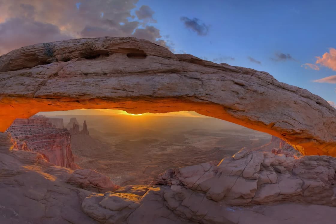
It suits photographers, with caveats. Mesa Arch is a well-known sunrise subject, and the National Park Service notes it is popular for that. Expect company.
Who should skip it
- People expecting a day trip from Provo. The Moab leg alone is three and a half to four hours by our Moab guide, and the park is another 40 minutes beyond town. A same-day round trip is about nine hours of driving.
- Anyone planning on the floor of the canyons in a regular car. The routes below the mesa are four-wheel-drive roads or strenuous trails.
- Visitors who dislike heights. The mesa sits on cliffs more than 1,000 feet above the surrounding terrain, and the overlooks and arch trail run along those edges.
- People who want shade, shops or restaurants. The park pages do not list food service or fuel at Island in the Sky, and the trails are exposed.
- Anyone who wants all four districts of Canyonlands. The Needles and the Maze are separate drives, and our Moab guide explains why Island in the Sky is the realistic one from Provo on a weekend.
Getting there from Provo
The route is the one in our Moab guide. From Provo, head southeast on US-6 through Spanish Fork Canyon to Price and Green River, then east on I-70 and south on US-191. Our Moab from Provo article describes that drive and its cautions, including that US-6 carries heavy freight and has limited passing.
Once on US-191, the Park Service describes the entrance route as about 10 miles north of Moab, then southwest on UT 313 for 22 miles. It adds that the park is 22 miles south of I-70 on US 191. Those two descriptions suggest more than one way to reach the turn, so read the directions on the park's Island in the Sky page rather than relying on memory.
One caution is printed on the park's own page: "A navigation system may send you the wrong way." The park recommends using a map. Download an offline map before you leave Provo, and do not assume you will have signal. The park pages we read describe wireless internet at the visitor center but do not describe cell coverage, so treat coverage as unconfirmed.
Fuel, food and the long stretch
The park pages do not mention fuel. Fill up in Moab, and buy lunch and water there before heading up. Our Moab guide also notes that fuel and food thin out between Price and Green River, so top up on the way down.
Costs
The National Park Service fee page lists these entrance prices:
- Private vehicle: $30, covering one private, non-commercial vehicle with 15 passengers or fewer.
- Motorcycle: $25, valid for 7 days.
- Per person on foot or bicycle: $15, with youth 15 and under free.
- Annual pass for Arches and Canyonlands: $55, valid one year through the month of purchase, for U.S. residents.
- America the Beautiful annual pass: $80 for residents.
- Island in the Sky campground: $15 per night.
The page also lists fee-free days for 2026, and the last one is November 11. That is Veterans Day, two days after this article's date. If you are planning a trip this week, check the fees page to confirm it applies to your plans, and keep in mind that other fees can still apply.
A Utah family that plans to see both Arches and Canyonlands in a year should compare the $55 pass to two $30 entries. Anyone already holding an America the Beautiful pass should confirm what it covers at the park. The fee page says it covers entrance and standard amenity fees at participating federal sites.
Dead Horse Point State Park sits on the same highway and is a Utah state park, so the national park fee and passes do not apply there. Our Moab guide makes the same point. Check the Utah State Parks page for its fee.
Timing: when to go and when to arrive
The Park Service's conditions page says that from March through November you should expect long entrance-road lines and full parking at popular trailheads and viewpoints. It names Easter, Memorial Day weekend, Labor Day weekend and Utah fall break in October as busy periods. Utah families are the people who set fall break, so a trip then competes with neighbors from home.
The park is generally open 24 hours a day year-round. The visitor center has its own hours, which vary by season, and the Park Service says some facilities close in winter and that the visitor center has some closed days in winter. The park pages we read did not list the hours themselves. Call 435-719-2313 or check the hours page.
Time of day
The park pages do not give sunrise or sunset times, so look those up for your date. The practical advice follows from what the park says about crowds:
- Mesa Arch is popular at sunrise, so if you want the arch without a crowd, arrive earlier than the photographers or after they leave.
- Parking at Grand View Point is small. The park says the lot has 44 formal spaces.
- Midday in summer is hot, and the park's trail guidance says to avoid hiking in peak summer heat.
Season
The summer is hot and the park advises avoiding hiking in peak heat. Spring and fall are busy. Winter is quieter, though the road and weather warnings below matter more, and some facilities close. Our Moab guide goes through the seasons for the wider area.
The stops, in the order you meet them
The park describes a paved scenic drive with many pullouts. The names below are the ones the National Park Service pages use. Distances are from the park's trail table.
Mesa Arch
Mesa Arch is a cliff-edge arch with views toward the La Sal Mountains. The trail is 0.6 miles round trip, rated easy, and about 30 minutes. For most families it is the single best stop for effort. Two rules matter: do not climb, scramble or stand on any arch, and keep children close to the edge. The park lists the arch trail among its easy walks, but it still runs near a drop.
Grand View Point
Grand View Point has an overlook and an out-and-back trail along the canyon edge with panoramic views. The trail is 1.8 miles round trip, rated easy, about 1.5 hours. The park says rangers give geology talks there from spring through fall.
This is the stop most affected by construction. The park's project is a multi-year reconfiguration of the parking lot. The current lot has 44 formal spaces, and the planned design adds formal stalls, walkways and expanded toilets. Phase Three in 2026 closed the overlook, the trail and 0.3 miles of road from 6 a.m. Monday to 4 p.m. Thursday each week, with the area reopening Thursday afternoon through the weekend. The Park Service's news release gave the work period as July 27 through October 1, 2026, while the project page showed a different date range in its summary, so the pages did not agree with each other. The final phase is scheduled for July through September 2027.
When the closure applies, the Park Service says cars, motorcycles, bikes and hikers must turn around at Orange Cliffs Overlook, and buses and long-trailer vehicles must not go past Green River Overlook. For a trip this winter, the 2026 schedule has ended on the dates given, but read the live pages. If you are planning for summer 2027, assume the work could affect weekdays and check.
Green River Overlook
The Park Service names Green River Overlook as a roadside viewpoint, and says it is near the campground. It is a pullout, not a hike, which is why it makes a good fallback when other parking is full.
Upheaval Dome
Upheaval Dome is the geological oddity of the district. The trail to the first overlook is 0.6 miles round trip, rated moderate, about 30 minutes, with a steep climb and about 100 feet of elevation change. A second overlook adds 1 mile and 50 feet of climb. The park's table says exhibits stand at the end of the trail.
Whale Rock
Whale Rock climbs a sandstone dome to broad views. It is 0.8 miles round trip, moderate, about one hour, with a 100-foot elevation change and steep drop-offs. The park singles it out, along with Gooseberry, for watching your footing on slopes, loose rock and sand.
Aztec Butte
Aztec Butte is 1.4 miles round trip, moderate, about 1.5 hours, through a sandy wash to a fork. One branch goes to a butte summit and the other to ancestral Puebloan structures, and the park says the route requires scrambling and has about 225 feet of elevation change. Do not touch or climb on archaeological sites; view the structures from a distance. Our ancestral Puebloans article gives background on who built them.
Murphy Point
Murphy Point is a 3.4-mile round trip, rated easy, about two hours. It passes a historic corral and ends with views of Candlestick Tower, the Green River and the White Rim Road. It is a good choice if you want a longer walk without a steep descent.
The long trails
Neck Spring (5.6 miles, moderate), Lathrop (5 miles to Canyon Rim, moderate), Gooseberry (4.6 miles, strenuous, dropping 1,400 feet) and Syncline (8.1 miles, strenuous, 5 to 7 hours) are for prepared hikers. The Park Service says Syncline has the most park rescues and recommends hiking it clockwise for more afternoon shade. Anyone ending a hike on the canyon floor has to climb back out.
Sample itineraries
These use only the stops and times in the park's table.
A half day on the mesa. Mesa Arch (about 30 minutes), Green River Overlook as a pullout, and Grand View Point if it is open (about 1.5 hours on the trail). That is a few hours of walking plus the drive between stops.
A fuller day. Add Upheaval Dome (30 minutes to the first overlook) and Whale Rock (about an hour). Add Murphy Point if the group wants a longer walk.
For anyone with only a short window. Pick Mesa Arch and one overlook. You will have seen the thing the park is known for.
The White Rim and the roads below the mesa
The White Rim is the bench of rock below the mesa, and several Island in the Sky features overlook it: the Murphy Point trail ends with views of the White Rim Road, and Gooseberry drops to the White Rim bench. The overlooks are the easy way to see it.
Driving it is different. The Park Service says four-wheel-drive roads in the park range from intermediate to extremely technical, and that rain and snow can quickly make unpaved roads require four-wheel drive or make them impassable. The pages we read did not give details on White Rim Road permits, length or vehicle requirements, and the permit page was not available when we tried to open it. So for anything below the mesa, check the official road conditions and permit pages and the visitor center, and do not attempt it in a passenger car.
What to bring
- Water. The park says water is scarce on the mesa. Carry at least 1 quart per person for short trails and up to 1 gallon for long ones.
- Offline map. The park warns that navigation may send you the wrong way.
- Food. Pack lunch. The pages we read do not list food service.
- Sun protection. The trails described are open and exposed, and the park says to avoid hiking in peak summer heat.
- Footwear with grip. The park flags loose rock, sand and steep slopes.
- A flashlight, map and basic first aid. The park's safety guidance lists these.
- Payment or pass. A pass for the national park does not cover state park fees at Dead Horse Point.
Safety and conditions
The park's own guidance is the best checklist:
- Avoid hiking during peak summer heat.
- Watch footing on steep slopes, loose rock and sand.
- Do not climb, scramble or stand on any arch.
- Do not touch or climb on archaeological sites.
- Trails are marked with cairns, but backcountry routes need a topographic map.
Remember that conditions can change quickly. A thunderstorm, a rain or a snowfall can affect unpaved roads, and the park says so. On an overnight stay in Moab, look at the forecast the morning you head up.
Cliff edges deserve a rule of their own for families. Keep small children within arm's reach at overlooks, and keep dogs and strollers back from the edge. Check the park's pet rules before bringing a dog, since we did not confirm them.
What to check before you go
- The Grand View Point Construction page. It lists phases, dates and what is closed. A final phase is set for July to September 2027.
- The Alerts and Conditions page. The version we read was marked last updated July 28, 2026.
- The visitor center hours. They vary by season, and some days close in winter.
- Road conditions. Especially after rain or snow, and for any four-wheel-drive route.
- Fees and passes. Confirm the $30 vehicle fee and whether a fee-free day applies.
- Your route. US-6 and I-70 conditions on the way down are covered by our Moab guide, and UDOT's travel information is the place for live road conditions.
- The Arches rules, if you are combining parks. See our Arches reservations article above.
Pairing it with other stops
Island in the Sky works well with a night in Moab and a visit to Arches the next morning. Our five-day loop puts Canyonlands in a longer route with Capitol Reef. If you want a plan that starts from the national parks as a group, see the Utah national parks from Provo, ranked.
After dark, the area is good for stars. Our stargazing near Provo guide and the Utah dark sky places guide cover the closer options, and the Moab guide describes the dark sky at Arches.
Bottom line
Island in the Sky is a good first Canyonlands visit for a Utah Valley family because the main sights are short, paved-road stops. Treat it as part of a Moab overnight, go early, bring more water than seems necessary, and read the live park pages for Grand View Point and for road conditions the week you leave. Anything this guide could not confirm, from fuel to cell coverage to White Rim permits, is flagged above and belongs on your pre-trip phone call to the park at 435-719-2313.
Related Guides
- Moab from Provo: Planning the Drive, Arches and Canyonlands
- Arches, Canyonlands and Capitol Reef: A Five-Day Loop From Provo
- Arches Entry Reservations: What Happened, and How to Check Before You Drive
- Goblin Valley and the San Rafael Swell from Provo
- Day Trips from Provo
Frequently Asked Questions
How far is Island in the Sky from Provo?
How much does it cost to enter Canyonlands National Park?
Is Mesa Arch a hard hike?
Is Grand View Point open?
Can I drive the White Rim Road in an ordinary car?
Is there water and food at Island in the Sky?
When is Island in the Sky busiest?
Can I camp at Island in the Sky?
Sources
The facts in this guide were checked against these sources. Hours, fees and rules change, so confirm anything time-sensitive with the source before you go. How we make Provo.com.
- Fees and Passes - Canyonlands National Park, National Park Service. Checked November 9, 2026.
- Alerts and Conditions - Canyonlands National Park, National Park Service. Checked November 9, 2026.
- Grand View Point Construction, National Park Service. Checked November 9, 2026.
- Island in the Sky, National Park Service. Checked November 9, 2026.
- Hiking - Canyonlands National Park, National Park Service. Checked November 9, 2026.