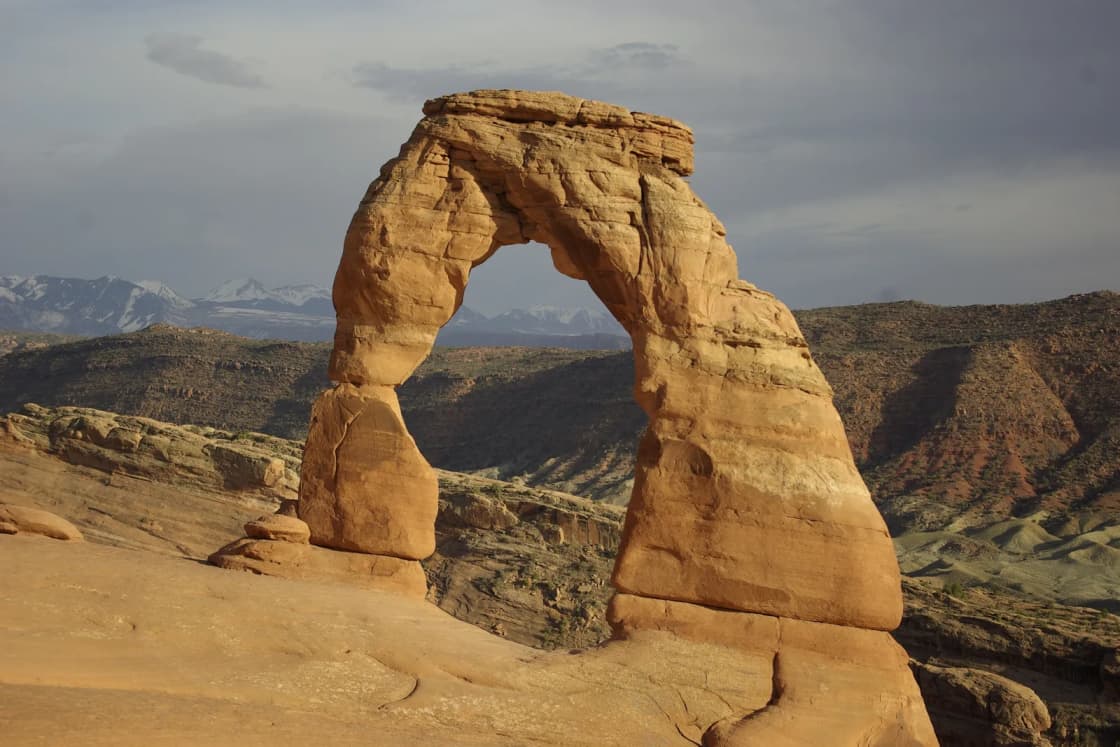
Delicate Arch is the arch on Utah license plates, and the walk to it is the hike most people from Utah Valley mean when they say they "did Arches." The National Park Service lists the trail at 3 miles round trip with 480 feet of elevation gain, steadily uphill, and it adds a warning that most trail pages skip: "Rangers frequently rescue people who underestimated the trail's difficulty." There is no shade on the main climb, the last stretch runs along a ledge, and the arch draws crowds at sunset. There is also a short-walk option. Two viewpoints at the end of the same spur road let people who can't or shouldn't do the hike see the arch from about a mile away. This guide covers the trail step by step, both viewpoints, how to choose between sunrise and sunset, and the heat, ice, kids and dogs questions, using what the Park Service and Visit Utah publish.
For the larger trip, including lodging, Canyonlands and the drive, start with our Moab from Provo guide. This page is the detail on one trail.
| Item | Detail | Source |
|---|---|---|
| Round-trip distance | 3 miles (accessibility page lists 3.2) | NPS |
| Elevation gain | 480 feet, steadily uphill | NPS |
| Hiking time | 2 to 3 hours | Visit Utah |
| Trailhead | Wolfe Ranch, 13.2 miles from the entrance | NPS |
| Drive inside the park | About 30 to 35 minutes to the trailhead | NPS |
| Lower Viewpoint | 200 feet round trip, level, wheelchair accessible | NPS |
| Upper Viewpoint | 0.5 mile, slopes and steps, 171 feet of elevation change | NPS |
| Arch opening | 46 feet high, 32 feet wide | NPS |
| Entry reservation | Not required in 2026 | NPS |
| Vehicle entrance fee | $30 | NPS fee page |
| Dogs | Not allowed on trails or at overlooks | NPS |
| Park phone | 435-719-2299 | NPS |
The drive from Provo
An OpenStreetMap routing estimate (OSRM) puts the Arches entrance about 187 miles from downtown Provo, a little under four hours without stops. The route is the one our Moab guide describes in detail: US-6 southeast from Spanish Fork through Spanish Fork Canyon and Price to Green River, east on I-70, then south on US-191.
The Park Service's own directions pick up at the interstate: take the Crescent Junction exit off I-70 and drive south on US-191 for 22 miles to the park. The entrance is north of Moab, 5 miles up US-191 from town, which matters for anyone coming from Provo. You reach the park before you reach Moab, so a group that wants to hike first and check in to a hotel later can turn left into Arches without driving into town and back.
Inside the park, the NPS directions page lists the Wolfe Ranch trailhead for Delicate Arch 13.2 miles from the entrance and visitor center, about 30 to 35 minutes, and the Delicate Arch Viewpoint 14.2 miles in. Visit Utah's directions describe the turn: drive north on the main park road to the right-hand turn signed for Delicate Arch and Wolfe Ranch, then follow Delicate Arch Road to the trailhead lot on the left. The viewpoint lot is at the end of the same road, past the trailhead.
Put together, plan on roughly four and a half hours from a Provo driveway to the trailhead with a fuel stop, and longer if there is a line at the entrance. The park's current conditions page says entrance waits between March and October may exceed 60 minutes. Check US-6 and I-70 before you leave on UDOT's traffic site, udottraffic.utah.gov, which carries traffic events, road weather forecasts in three-hour blocks and live cameras. Our road conditions guide has the other places to look.
Reservations, fees and hours
Timed entry. Arches does not require a timed-entry reservation in 2026. The NPS announced on Feb. 18, 2026, that the park "will not require advanced timed-entry reservations this year" and that visitors may enter at any time during operating hours. The park's Plan Your Visit page, last updated April 8, 2026, repeats that. As of Nov. 14, 2026, the park's timed-entry page says only that it is "currently being worked on," and none of the Arches pages checked for this guide say anything about 2027. Our Arches entry reservations explainer covers the history and how to check before you drive. Do not assume the 2026 rule carries into next season until the park says so.
No trail permit. The Delicate Arch trail does not need a permit or a separate reservation. In Arches, reservations are still required for Devils Garden Campground and for self-guided and ranger-led Fiery Furnace hikes, according to the park; our Fiery Furnace guide has those details.
Fees. The park's fee page, last updated April 18, 2025, lists $30 per private vehicle, $25 per motorcycle and $15 per person on foot or bicycle, with youth 15 and under free. A $55 annual pass covers Arches, Canyonlands, Natural Bridges and Hovenweep for U.S. residents, and the America the Beautiful pass is $80 for U.S. residents and $250 for nonresidents. The NPS nonresident fee page, updated July 15, 2026, lists 11 parks with an extra $100 per person charge for non-U.S. residents age 16 and older; Arches is not on that list, though Zion and Bryce Canyon are. Our national park passes guide works through the pass math.
Hours. The park's hours page says Arches is "normally open year-round, 24 hours a day," which is what makes a sunrise hike possible. The page notes that fees apply. It also advises entering before 8 a.m. or after 3 p.m. during the busy March to October season.
Wolfe Ranch and the petroglyphs
The hike starts at Wolfe Ranch, and the first few minutes are the easiest and most historic part of the walk. The NPS trailhead page says the first section of trail, to the Wolfe Ranch cabin and the petroglyph panel, is accessible to wheelchairs; the park's hiking-access page describes that path as flat with a gravel surface. The trailhead has vault toilets, and Visit Utah says they are open year-round but that there is no drinking water. Fill bottles before you drive in; the NPS lists water at the visitor center and Devils Garden Campground.
The cabin. According to the Park Service, John Wesley Wolfe, a Civil War veteran, came to this spot in 1898 at age 69, looking for a drier climate for an old leg injury, and brought his oldest son, Fred. In 1906 his daughter Flora arrived with her husband, Ed Stanley, and their two children. The NPS says Flora was "appalled" by how her father and brother were living and demanded a new cabin with a wooden floor and real windows. That cabin still stands. Six people shared its one room, which measures 17 by 15 feet. Wolfe sold the ranch in 1910 and died in Ohio in 1913 at 84. The ranch was listed on the National Register of Historic Places in 1975. Flora also took one of the earliest photographs of Delicate Arch, according to the park.
The petroglyphs. A short distance past the cabin is a rock wall with petroglyphs. The NPS describes etchings of bighorn sheep and figures on horseback and says the riders mean the panel was created after 1600, when the Ute are thought to have acquired horses. Look but do not touch; the park prohibits carving, scratching, chalking or any marking on rock and asks visitors to report graffiti to a ranger.
If you are short on energy on the way out, this is a good place to stop. On the way back, Visit Utah suggests a quarter-mile detour to see the cabin and panel if you skipped them at the start.
The hike, step by step
Rolling start. Past the ranch, Visit Utah describes the trail climbing over rolling hills. This section is sandy and gentle, and it lulls people into a pace they cannot keep on the slickrock ahead.
The slickrock climb. Then comes the part that defines the hike. Visit Utah describes "a steep ascent on a slickrock slope with no shade." The NPS calls the trail steadily uphill, and the park's physical accessibility data for the route lists a hard bedrock surface, a typical grade of 9 percent and a maximum grade of 80 percent, with cross slopes up to 41 percent. Those numbers explain why people who expected a stroll end up sitting on the rock halfway up. Set an easy pace, take breaks before you need them, and drink on the way up rather than waiting for the arch.
The domes and cairns. Visit Utah says the trail levels out after the slickrock climb and passes among large sandstone domes, with cairns marking the way. The Park Service notes that many Arches trails cross broad rock and use cairns, so you need to pay attention to follow them. Stay on the route; stepping off it onto the dark, crusty soil damages biological soil crust, which the park says supports desert plant life. Do not build or move cairns.
Frame Arch. Near the end, Visit Utah points out Frame Arch, also called Twisted Doughnut Arch, a small opening off to the right that frames Delicate Arch for a photo. It also says to be careful climbing up to it.
The ledge. The final approach, in Visit Utah's words, "follows a ledge that hugs a rock wall for 200 yards." This is the stretch to keep children close and to step aside rather than pass when someone is coming the other way. It is also where ice tends to linger in winter, covered below.
The bowl and the arch. The ledge rounds a corner and the arch appears across a slickrock bowl. The NPS lists the opening at 46 feet high and 32 feet wide, the largest free-standing arch in the park. Earlier names for it included "Cowboy's Chaps," "Old Maid's Bloomers" and "Salt Wash Arch," and the park says the name "Delicate" first appeared in a January 1934 article about a scientific expedition to the then-national monument. Visit Utah says you can walk over for a photo standing under the arch, and asks that you move away when you are done so others can get theirs. Walking, climbing, scrambling or standing on any arch is prohibited in Arches.
The way down. You return the same way. The slickrock that was a slog going up is a steady downhill going down, and that is where tired legs slip. In low light, the cairns are harder to pick out.
Parking overflow. The NPS says the Wolfe Ranch lot fills on very busy days. When it does, the park points to the Delicate Arch Viewpoint lot, but walking from there adds a mile along the road each way, making the round trip about 5 miles. The park also asks visitors not to wait in roadways for parking and not to park on vegetation, and it says staff may temporarily restrict access to specific areas when lots fill.
The Lower and Upper viewpoints
The NPS notes that Delicate Arch is hard to see from the main park road; you have to get out of the car. For people who can't do the hike, or don't want to, there are two viewpoints at the end of Delicate Arch Road, past the trailhead. They share a parking area with restrooms, and the NPS lists it as 14.2 miles from the entrance.
Lower Delicate Arch Viewpoint. This is the option for wheelchairs, strollers, bad knees and short winter afternoons. The NPS lists it as 200 feet round trip, 5 to 15 minutes, with no elevation change and "a level, hardened surface with a wide pathway" that is wheelchair accessible. The park's accessibility data adds a 12-foot minimum tread width, grades of 8 percent or less and cross slopes no steeper than 5 percent; a separate NPS page describes the surface as packed gravel. From here the arch is visible about a mile away, small on the skyline.
Upper Delicate Arch Viewpoint. This is a real walk, though a short one. The NPS lists it at 0.5 mile round trip, 30 to 45 minutes, with 171 feet of elevation change, and calls it moderately strenuous: the trail "climbs up slopes and steps and is not accessible to wheelchairs." The accessibility data lists a typical grade of 9 percent and a maximum of 41 percent. The reward is what the park calls a "slightly less obstructed view," looking across a canyon to the arch about a mile away. You will not get the scale you get standing in the bowl, but by the park's time estimate you will be back at the car in under an hour.
Splitting a group works well here. Hikers can start at Wolfe Ranch while others drive the extra distance to the viewpoint lot, and both groups can watch the same sunset from different sides of the canyon. Arrange a meeting time and place first, because phone coverage in the park is spotty, according to the NPS.
Sunrise or sunset
The NPS says the trail "is often busy throughout much of the year" and that "sunset is particularly busy, sometimes with hundreds of people at the arch at once." Visit Utah says the same about summer sunsets and photographers, and it describes the other option this way: at sunrise, the sun rises behind the arch.
That sums up the choice:
- Sunset puts warm, low light on the face of the arch, which is the classic photograph. It is also the busiest window, and your descent happens in fading light. It fits a Provo departure in the morning: drive down, check in, hike late.
- Sunrise means walking up in the dark, a backlit arch, colder rock and, on most days, a fraction of the sunset crowd. In summer it is the safer choice for heat, since the climb happens before the sun reaches the slickrock. It requires being in Moab the night before.
Here are sunrise, sunset and the end of evening civil twilight near Delicate Arch for a few dates, from the U.S. Naval Observatory. Times are local; the summer dates are daylight time.
| Date | Sunrise / sunset | Civil twilight ends |
|---|---|---|
| Nov. 14, 2026 | 6:59 a.m. / 5:05 p.m. | 5:34 p.m. |
| Dec. 21, 2026 | 7:33 a.m. / 5:00 p.m. | 5:30 p.m. |
| March 20, 2027 | 7:22 a.m. / 7:30 p.m. | 7:56 p.m. |
| June 21, 2027 | 5:53 a.m. / 8:46 p.m. | 9:18 p.m. |
| Sept. 22, 2027 | 7:06 a.m. / 7:15 p.m. | 7:42 p.m. |
To time it, work backward from Visit Utah's 2 to 3 hour round-trip estimate. A reasonable plan is to allow at least half of that, plus a margin, for the climb, so a sunset hiker in November would be leaving Wolfe Ranch by about 3:30 p.m. to sit at the arch before 5:05. After civil twilight ends, about half an hour after sunset, you are on slickrock and cairns by headlamp. Everyone needs their own light, not one phone for the group.
For sunrise in summer, the June numbers mean leaving a Moab hotel well before 5 a.m. The park is open 24 hours, so there is no gate problem, and the NPS encourages after-hours visits: Arches is an International Dark Sky Park. Our dark sky places guide covers what that designation means.
A middle option is to skip both ends. On a cool spring or fall weekday, a midmorning hike avoids the sunset crowd and the dark descent. In summer that option does not exist, for the reasons below.
Heat in summer
The NPS almanac lists an average July high of 100 degrees and an August average of 97, and the park's weather page says summer temperatures often rise above 100, which "makes strenuous exercise difficult." The Delicate Arch climb is the definition of strenuous exercise on bare rock in full sun. The park's safety page tells visitors to plan activities for early morning or late evening and to avoid "the period between 10 am and 5 pm when the sun is strongest." Visit Utah says park officials discourage hiking this trail midday in summer.
The NPS recommends carrying at least 2 to 3 liters of water per person for front-country hikes like this one. Visit Utah says at least two quarts per person. In July, more is better; there is no water at the trailhead. The park's safety page lists heat and sun exposure among the most common reasons for its hundreds of search and rescue calls each year.
Late summer adds monsoon storms. The NPS says the season "brings violent storm cells which often cause flash floods," along with lightning, wind and hail. The slickrock bowl at the arch is exposed. The park's advice if you hear thunder is to seek shelter immediately and wait at least 30 minutes after the last thunder, and to avoid tall rock outcroppings. On an afternoon with building clouds, the viewpoints are the better choice.
Ice in winter
Winter is the quiet season at Delicate Arch, and the park's winter page is clear about the tradeoff. "Popular trails like Delicate Arch and Devils Garden quickly become slippery from packed snow and ice," it says, and "shady trails, like the one to Delicate Arch, can be icy through early spring." The page recommends traction devices and trekking poles. Visit Utah gives the same advice, saying you may need poles or shoe spikes.
The likely trouble spot is the shaded ledge near the end. The park's almanac lists a November average high of 56 and low of 30, and December averages of 45 and 23, so freezing mornings are normal and shaded rock can hold ice well after the open slickrock has dried. The winter page also says drifting snow can cover trail markers and that the park road may close for several hours after a snowfall for plowing.
Two practical rules for a winter trip from Provo: stop at the visitor center, open 9 a.m. to 4 p.m. daily in winter and closed Dec. 25, and ask about ice on the ledge; and treat the Lower Viewpoint as the plan if you have no traction devices. Our winter driving guide covers the US-6 side of a winter trip.
Kids on the trail
Distance is not the main issue for school-age children. The ledge is. Visit Utah's description of the last 200 yards includes a direct note to keep an eye on kids, and the bowl at the arch has open slopes and drop-offs. Hold younger children's hands on the ledge and keep them away from the edges of the bowl.
Heat hits kids faster than adults, and so does the slickrock climb. For young children, the better choice in summer is the Lower Viewpoint, the Windows Section elsewhere in the park, or a cooler day. The Wolfe Ranch cabin and petroglyph panel at the start are flat and short enough for any age and make a good destination on their own. For hikes closer to home, see our hikes for kids under 8 guide.
Dogs: not on the trail or the viewpoints
The Arches pets page is unambiguous. Pets are not allowed "on any hiking trails, or anywhere off-trail, even while in a carrier," and not "at any overlooks." That includes the Delicate Arch trail and both viewpoints. Leashed pets on a 6-foot or shorter leash are allowed along established roads, in parking areas, and in campgrounds and picnic areas, and pets cannot be tied to anything except your own parked vehicle.
Leaving a dog in the car is not a workaround for most of the year. The park warns that "when air temperatures exceed 65°F/18°C, a pet in a vehicle may die, even with the windows cracked," and that temperatures in Arches regularly exceed 100 degrees. If the dog is coming to Moab, plan the Delicate Arch hike around a kennel or a person who stays with it, and look at our dog-friendly hikes near Provo for trips the dog can join. Corona Arch on BLM land outside the park allows leashed dogs, with caveats covered in our Corona Arch guide.
What to bring
- Water. At least 2 to 3 liters per person, the NPS minimum for front-country hikes, and more in summer. There is none at Wolfe Ranch.
- Shoes with grippy soles. The route is mostly bedrock with steep pitches.
- A headlamp for each person for any sunrise or sunset hike.
- Traction devices and trekking poles in winter and early spring, as the park recommends.
- Layers. Spring and fall nights can be 30 degrees cooler than the afternoon, according to Visit Utah, and winter lows average 0 to 20 degrees, according to the NPS winter page.
- Sun protection and a hat. There is no shade on the main climb.
- Salty snacks and a small pack to keep your hands free on the rock.
- An offline map. The NPS suggests downloading park maps in the NPS App before you lose service.
Who should skip the hike
The viewpoints exist for good reasons. Consider them instead of the full trail if any of these apply:
- Anyone with heart, lung or joint problems that make a sustained climb hard. The NPS asks hikers to consider their own health and fitness before starting, and the rescue warning on its trail page is there because people don't.
- A summer midday start. Between 10 a.m. and 5 p.m. in summer, the park's own advice is not to be doing this.
- Icy conditions without traction. The ledge is the wrong place to discover the ice.
- A rushed sunset. If you would be starting late enough to descend in full dark, see the arch from the viewpoints instead.
- Groups with a dog and no one to stay with it. Dogs are not allowed on the trail or the overlooks.
- Wheelchair users and people using strollers, for whom the Lower Viewpoint and the flat path to Wolfe Ranch are the accessible options.
Photography notes
- The light. Sunset lights the face of the arch; at sunrise, the sun comes up behind it, according to Visit Utah.
- Frame Arch. The small opening off the trail before the ledge frames Delicate Arch. Visit Utah calls it a great photo spot and says to be careful climbing up to it.
- The far end of the bowl. Visit Utah suggests walking along the bowl for different angles, including the far end. Stay off the arch itself.
- Share the spot under the arch. Take your photo and move aside, as Visit Utah asks.
- From the viewpoints, the arch is about a mile away, so a longer lens or a phone's telephoto setting helps.
- No drones. The park's laws and policies page lists a superintendent's determination prohibiting unmanned aircraft in the Southeast Utah Group parks, which include Arches.
- Night sky. Arches is an International Dark Sky Park, and the NPS encourages after-hours visits. Plan any night photography with the same headlamp and descent cautions as a sunset hike.
What to check before you leave Provo
- Park alerts and entry rules at nps.gov/arch, especially for any 2027 reservation announcement.
- The entrance webcam at go.nps.gov/archeswebcam, which the park recommends for real-time conditions.
- Road conditions for US-6, I-70 and US-191 at udottraffic.utah.gov.
- Sunset or sunrise time for your date, and the end of civil twilight.
- Ice and trail conditions by calling the park at 435-719-2299 or asking at the visitor center.
- Weather, including summer thunderstorm forecasts.
For a full weekend that pairs Delicate Arch with Canyonlands, see our two-day Arches and Canyonlands itinerary, the Island in the Sky guide for Mesa Arch at sunrise, and our ranking of Utah's national parks from Provo.
Related Guides
- Moab from Provo: Planning the Drive, Arches and Canyonlands
- Arches Entry Reservations: What Happened, and How to Check Before You Drive
- Arches and Canyonlands in Two Days From Provo
- Fiery Furnace in Arches: Permits, Ranger Hikes and Why You Cannot Wander In
- Corona Arch and Bowtie Arch: The Hike Off Potash Road, With the Rail Crossing
- Canyonlands Island in the Sky: Mesa Arch, Grand View Point and the Short Drive In
- Arches, Canyonlands and Capitol Reef: A Five-Day Loop From Provo
- Utah National Park Passes Explained
- Hikes for Kids Under 8 Near Provo
- Devils Garden in Arches: Landscape Arch, Double O Arch and the Primitive Loop
- Why Utah Has So Many Arches, and How One Forms
Frequently Asked Questions
How long is the Delicate Arch hike?
Is the Delicate Arch hike hard?
Can I see Delicate Arch without doing the hike?
Is sunrise or sunset better at Delicate Arch?
Are dogs allowed on the Delicate Arch trail?
Do I need a reservation to hike Delicate Arch?
Is Delicate Arch icy in winter?
How far is Delicate Arch from Provo?
Sources
The facts in this guide were checked against these sources. Hours, fees and rules change, so confirm anything time-sensitive with the source before you go. How we make Provo.com.
- National Park Service, Arches National Park: Delicate Arch, National Park Service, Arches National Park. Checked November 14, 2026.
- Delicate Arch Viewpoints, National Park Service. Checked November 14, 2026.
- Wolfe Ranch Trailhead, National Park Service. Checked November 14, 2026.
- National Park Service: Wolfe Ranch, National Park Service. Checked November 14, 2026.
- Native Americans (prehistoric visitors), National Park Service, Arches National Park. Checked November 14, 2026.
- Physical/Mobility Accessibility, National Park Service, Arches National Park. Checked November 14, 2026.
- National Park Service, Arches National Park: Pets, National Park Service, Arches National Park. Checked November 14, 2026.
- National Park Service, Arches National Park: Safety, National Park Service, Arches National Park. Checked November 14, 2026.
- Visiting in Winter, National Park Service, Arches National Park. Checked November 14, 2026.
- National Park Service, Arches National Park: Weather, National Park Service, Arches National Park. Checked November 14, 2026.
- Fees and Passes, National Park Service, Arches National Park. Checked November 14, 2026.
- Nonresident Fees, National Park Service. Checked November 14, 2026.
- Arches will not require timed-entry reservations in 2026, National Park Service, Arches National Park. Checked November 14, 2026.
- Plan Your Visit, National Park Service, Arches National Park. Checked November 14, 2026.
- National Park Service, Arches National Park: Directions, National Park Service, Arches National Park. Checked November 14, 2026.
- Operating Hours and Seasons, National Park Service, Arches National Park. Checked November 14, 2026.
- Current Conditions, National Park Service, Arches National Park. Checked November 14, 2026.
- Sun and Moon Data for One Day, U.S. Naval Observatory. Checked November 14, 2026.
- Utah Department of Transportation: UDOT Traffic, Utah Department of Transportation. Checked November 14, 2026.
- Visit Utah (Utah Office of Tourism): Delicate Arch, Visit Utah (Utah Office of Tourism). Checked November 14, 2026.