
Everybody in Utah Valley knows Mount Timpanogos. It fills the windscreen on the drive north, it has a marathon named after it, and several thousand people a year walk to the top of it.
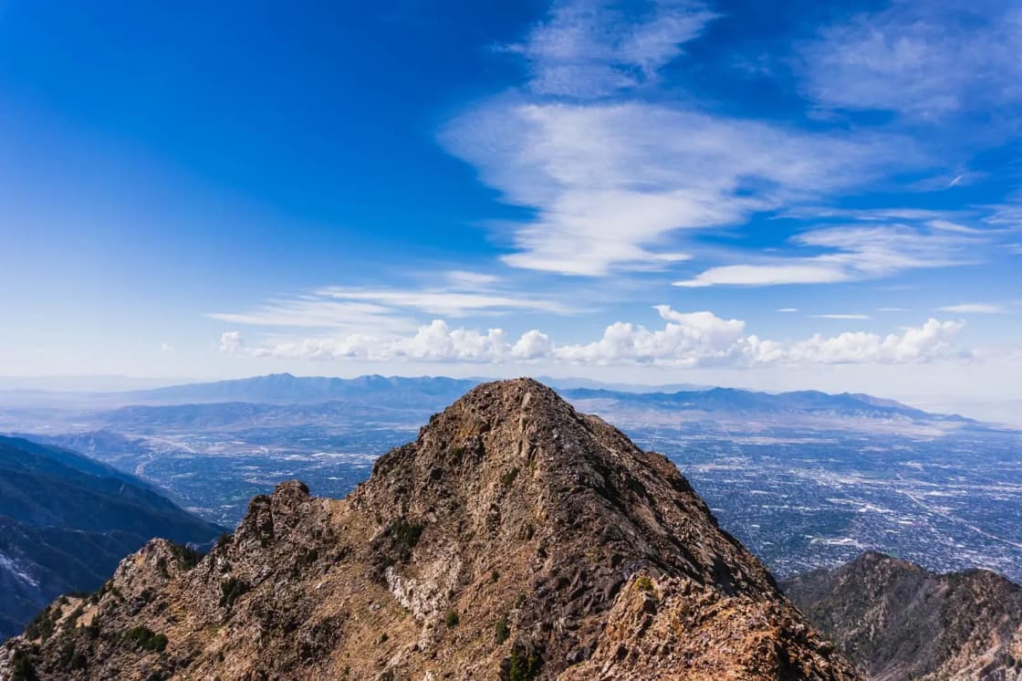
Mount Nebo is taller. It is the highest peak in the entire Wasatch Range and the high point of Utah County, it rises more than a mile above the valley floor at Mona, and on a clear day you can see it from the shore of Utah Lake. It gets a fraction of the traffic — partly because it sits at the far south end of the county, and partly because nothing about it is casual.
This is a guide to actually climbing it: the three routes, the season, and the two facts about this mountain that almost every listing gets wrong.
The elevation nobody agrees on
Search for the height of Mount Nebo and you will be given 11,877 feet, 11,928 feet and 11,933 feet, often by sources that ought to know.
This is not sloppiness. There are two separate things going on, and once you see them the numbers stop conflicting.
First: there are two summits. Mount Nebo is a long north–south ridge with several high points on it. The two that matter are the north summit, which is the true top, and the south summit, roughly fifty feet lower. The middle summit sits between them, lower again.
Second: there are two vertical datums. The older survey figures and the modern NAVD 88 recomputation differ by about five feet on this mountain.
Line them up and it resolves cleanly:
| Figure | What it is |
|---|---|
| 11,877 ft | South summit, older survey |
| 11,882 ft | South summit, NAVD 88 |
| 11,928 ft | North summit, older survey — the most-quoted number |
| 11,933 ft | North summit, NAVD 88 |
The tell is the consistent five-foot offset on both summits. If two sources disagreed because one of them had measured badly, the error would not repeat itself identically on a different peak a mile down the ridge. A systematic offset across both points is the signature of a datum change, not a dispute.
The part that is a genuine error
Here is where it gets interesting. The Forest Service publishes the wrong summit's elevation as the mountain's height, on its own website, repeatedly.
The Uinta-Wasatch-Cache National Forest's wilderness page, its Spanish Fork Ranger District page and its Nebo Loop byway page all describe Mount Nebo as 11,877 feet — which is the south summit on the old survey. Meanwhile the same agency's own North Peak Trail #089 page correctly gives the summit as 11,928.
The reason this fossil survives is documented: early surveys placed the southern peak as the highest, and the mountain was resurveyed in the 1970s, at which point the northern peak was found to be higher. The 11,877 figure is a pre-1970s answer that the land manager's own general-interest pages have never been updated to reflect, even though its trail pages have.
Two practical consequences. If you are peak-bagging, the number you want is the north summit. And if you are relying on an official page for anything else about this mountain, check whether the same page is quoting a fifty-year-old elevation before you trust the rest of it.
Which summit you end up on depends on the route
This follows directly from the survey history and it catches people out.
The most substantial trail on the mountain goes to the south summit — the one the old surveys called the top. That is why the trail exists where it does, and it is why hikers who have "done Mount Nebo" have sometimes not stood on the highest ground on it.
If reaching the true high point matters to you, you want a route that finishes on the north summit. If you simply want a hard, beautiful day above treeline, either end of the ridge delivers, and the south summit is reached by better trail.
The three routes
North Peak Trail #089 — the shortest way to the true summit
The Forest Service is explicit that this is the shortest trail to the top of Mount Nebo. It starts northeast of the mountain, follows a fence line at the trailhead and climbs steadily for nearly its entire length, through conifer stands and meadows, much of it on a ridge with some steep and rocky switchbacks.
It leads first to North Peak, then drops into Wolf Pass. From there, a non-maintained route continues to the summit — a rocky scramble along a narrow ridge. That distinction matters: the maintained trail ends before the summit does.
Trip reports commonly describe substantially more total ascent than the raw trailhead-to-summit difference suggests, because the ridge gives back elevation repeatedly on the way. Budget for a full day, not for the number you get by subtracting two elevations.
Nebo Peak Trail #116 — the classic route, to the south summit
Officially the Mount Nebo Trail, this is the rugged wilderness route the Forest Service describes as leading to the south summit. It opens with a series of switchbacks up to the ridge, meets the Willow Canyon Trail #118, and then turns north along the main ridge to the top.
Two notes straight from the agency: the upper portion is rough and narrow, and horses are not recommended past the Willow Canyon junction. The Forest Service's own advice is to plan a full day for the round trip.
Nebo Bench Trail #117 — the long traverse
The Nebo Bench Trail begins at the south end of the Monument trailhead parking area and runs along the east slopes of the mountain at roughly 9,000 feet, through basins and meadows that carry serious wildflowers at the right time of year.
The honest warning is in the agency's own description: at about five miles in, the trail receives less use and can be difficult to follow, particularly across the meadows. Its southern end descends through oak and maple into Salt Creek Canyon. It is a full day one way.
It connects to both #116 and #118, which is why it appears in most of the ambitious loop and traverse routes people build on this mountain — including the full three-summit traverse along the crest, which involves exposed scrambling and is a different proposition again.
Andrews Ridge — the other south approach
A long climb from the Nebo Loop road up Andrews Ridge to the south peak. It can be overgrown low down, breaks onto a long open ridge with wide views over Nephi and central Utah, and spends hours above treeline. Nontechnical, but demanding, with a punishing descent on tired legs.
Getting there from Provo
Everything starts with the Nebo Loop Scenic Byway, which leaves I-15 at Payson, climbs through Payson Canyon and works around the back of the mountain before dropping to Nephi. It is the access road for the trailheads and it is a fine drive in its own right.
The practical constraint: the byway closes for winter. It is a high mountain road that shuts with the snow and reopens in late spring, which means the summit season and the road season are the same season. From Provo, allow roughly an hour to reach Payson and then a substantial further drive up the byway depending on which trailhead you want.
Fill up in Payson or Nephi. There is no fuel, no food and no reliable water on the byway, and cell coverage is patchy to nonexistent for long stretches. Download your maps in town.
Finding the trailheads
The Nebo Bench trailhead is the one most descriptions point at, and it sits a long way up: from Payson, roughly 24 miles along the byway to the signed turning. From there a dirt track — Mona Pole Road — runs a further third of a mile along a fence line to a second parking area slightly nearer the mountain. Either works; the second saves a few minutes and costs a little clearance.
The signage on this mountain is not generous. Trails interconnect, junctions are not always marked, and the Forest Service's own descriptions repeatedly note tread that fades in the meadows. Carry a map and know your route before you leave the car. This is not the Wasatch bench, where a wrong turn puts you on a different popular trail; here a wrong turn puts you in an unmarked basin at 10,000 feet.
The altitude is the part people underestimate
Utah Valley sits at about 4,500 feet, which already does most visitors a favor. Mount Nebo does not.
You spend the back half of any summit route between 10,000 and 11,900 feet, and the effect is cumulative rather than dramatic: slower pace, heavier breathing, a headache that arrives in the afternoon and is easy to mistake for dehydration. Interpolated climate data for the area around the summit puts the average daily high in July at around 67°F — pleasant if you are moving, cold the moment you stop, and cold enough on an exposed ridge in wind to matter. Even in August, a layer is not optional.
Three things follow, and none of them are optional either:
- Start early. Not for the view. For the storms and for the descent, which is where tired people get hurt.
- Carry more water than the mileage suggests. No sources, several thousand feet of climb, and altitude accelerates fluid loss.
- Turn around on a schedule, not on a feeling. Above treeline on a non-maintained ridge is the wrong place to renegotiate.
The mountain itself
A few things worth knowing about what you are standing on.
The name is biblical. Mount Nebo is named for the mountain in Jordan, east of the Jordan River, described as the place from which Moses saw the promised land and where he died. The naming fits the geography — this is the peak at the end of the range, looking out over everything south of it — and it is one of a great many Utah place names drawn from scripture. The first recorded ascent was in 1869.
It is an "ultra". Mount Nebo has more than 5,400 feet of topographic prominence, which puts it among roughly 128 ultra-prominent peaks in the United States and ranks it around 91st in the country on that measure. It is also one of the most isolated major summits in the US — the nearest higher ground is over 75 miles away. Prominence and isolation are the technical explanation for something you notice immediately from the valley floor: it stands alone in a way Timpanogos, hemmed in by the rest of the range, does not.
You can see it from Provo. On a clear day, the bulk closing off the south end of Utah Valley, visible from the shore of Utah Lake and from most of the west-facing benches, is this mountain.
The season, honestly
The mountain is typically partly or completely snow-covered from mid-October until July. That is not a warning about the summit block; it is the state of the mountain.
- July — the earliest realistic month, often with snow lingering in the gullies and on north aspects.
- Late July to mid-September — the reliable window, and the best of it.
- Late September to early October — cold, clear, superb light, short days.
- Mid-October onward — snow, and eventually a closed road.
August brings the standard Wasatch hazard: afternoon thunderstorms that build fast, on a route that spends hours on an exposed alpine ridge with nowhere to shelter. The usual answer applies, doubled at this elevation — start before dawn and be off the ridge by early afternoon.
What you walk through
The Forest Service describes the biological sequence on the way up, and it is one of the better reasons to do this hike: you start in sagebrush and cliffrose, climb through mountain brush — oakbrush and mahogany — then aspen and white fir, then spruce and subalpine fir, and finally break out at timberline into an alpine zone of primrose, alpine moss and tundra plants. Wilderness elevation here starts around 5,400 feet, so you cross the full range in a day.
Wildlife is genuinely abundant: bobcats, mule deer, elk and moose are commonly seen. Black bears and mountain lions are present and rarely seen. Cattle graze parts of the lower country and can obscure the start of the Nebo Bench trail where it leaves the trailhead.
The mountain is an ultra-prominent peak — one of a small number in the United States with more than 4,900 feet of topographic prominence — which is the technical way of saying what your legs will tell you anyway: nothing near it is anywhere close to as tall.
Rules that actually bite
- This is designated Wilderness. No motorized or mechanized equipment, which means no bicycles on the summit trails.
- Groups, fires and camping follow standard wilderness practice. There are campsites along the Nebo Bench Trail and people use the mountain as an overnight, which is a sensible way to break up a long summit day.
- Leave No Trace applies with force at altitude. Alpine vegetation above treeline recovers on a timescale of decades.
- Horses: the Forest Service advises against taking them past the Willow Canyon junction on #116, and flags questionable sections on the Nebo Bench. Local riders have warned about this mountain for generations.
Should you do this instead of Timpanogos?
A fair question, and the answer depends on what you want.
Choose Timpanogos if you want the famous one, a maintained trail the whole way, company on the mountain, mountain goats, and a trailhead about forty minutes from Provo.
Choose Nebo if you want the actual high point of the range, near-solitude, a genuine alpine ridge, and a day that feels remote in a way nothing on the Provo bench does. Understand that you are trading a maintained path for route-finding, and a busy trail for one where an injury is a much bigger problem.
For everything closer to home, the complete Provo hiking guide covers the bench trails, and six lesser-known hikes includes Grotto Falls in Payson Canyon — a good half-day if you drive up the byway and decide the summit can wait. Things to do in Payson covers the town at the bottom of the road.
Practical summary
- Summit: north summit, the true high point of the Wasatch Range and of Utah County.
- Elevation: ~11,928 ft on the widely-quoted survey; ~11,933 ft NAVD 88. Sources giving 11,877 are quoting the south summit on a pre-1970s survey.
- Shortest route: North Peak Trail #089, finishing on a non-maintained scramble from Wolf Pass.
- Best-trailed route: Nebo Peak Trail #116, to the south summit.
- Long option: Nebo Bench Trail #117 from the Monument trailhead — hard to follow past about five miles.
- Season: July to early October; snow-covered mid-October to July.
- Access: via the Nebo Loop Scenic Byway from Payson; road closed in winter.
- Water: none. Carry all of it.
- Bikes: not permitted — designated Wilderness.
- Managing agency: Spanish Fork Ranger District, Uinta-Wasatch-Cache National Forest.
Trail conditions, road status and any seasonal closure are worth confirming with the ranger district before you drive down, particularly early and late in the window. On this mountain the road being open and the route being sensible are two separate questions.
Related Guides
- ATV & UTV Rentals Near Provo: Nobody Rents From Provo, and Other Things Worth Knowing First
- Running Routes in Provo: A Runner's Guide (2026)
- Tibble Fork Reservoir: What to Know Before You Go
- Golf in Utah Valley: The Complete Guide to Every Course Worth Playing
- Hobble Creek Canyon: The Name Springville Gave Away
- Horseback Riding in Utah Valley: Where to Ride, What It's Actually Like, and Who Takes Beginners
- The Murdock Canal Trail: Utah County's Flat 17 Miles
- Utah Valley Hike Finder — filter every trail by difficulty, length, season, dogs and fees
- Fly Fishing the Provo River: Three Rivers Wearing One Name
- Payson Lakes and Payson Canyon: The Complete Guide
Frequently Asked Questions
How tall is Mount Nebo?
Is Mount Nebo higher than Mount Timpanogos?
What is the shortest route to the summit of Mount Nebo?
How hard is the Mount Nebo hike?
When can you hike Mount Nebo?
Is there water on the Mount Nebo trails?
Can you mountain bike Mount Nebo?
Can you drive up Mount Nebo?