
More on The South Valley: every guide we have published there, in one place.
The south end of Utah Valley gets skipped. Provo and Orem absorb the attention, the north county has the outlets and Thanksgiving Point, and Mapleton, Salem and Santaquin sit quietly below all of it with a combined population smaller than a single Provo neighborhood.
That is a fair reflection of how much commercial activity is down there and a poor reflection of what is behind the towns. The canyons above this stretch are among the least crowded in the valley, some of the last working orchards in Utah County are on the Santaquin bench, and one of the region's best group campgrounds is three miles from Mapleton's Main Street.
This page routes you. The headline attractions at this end — Mount Nebo, the Nebo Loop Scenic Byway, the u-pick orchards — already have their own guides. What follows is the local material that does not, plus the mix-up that sends people an hour in the wrong direction.
Start with the Maple Canyon problem
If you take one thing from this page, take this.
Utah has two Maple Canyons, roughly sixty miles apart, and search results conflate them constantly.
Mapleton's Maple Canyon is a modest Wasatch canyon immediately east of town. It holds Whiting Campground, sits at about 5,400 feet, and is full of maple and cottonwood. It is a family, horse and short-hike canyon.
Sanpete County's Maple Canyon is a world-renowned rock climbing destination in the Sanpitch Mountains, about three miles from the tiny community of Freedom and reached from Fountain Green or Moroni. Its walls are conglomerate — ancient river cobbles compressed into rock, producing the cobble-pulling climbing style the canyon is famous for — and they rise in sheer walls on both sides. Climbers come from around the world for it.
Why this matters practically. If someone tells you Maple Canyon has world-class climbing, they mean Sanpete, and it is not a Utah Valley day trip in the casual sense — it is over the mountains in a different county. If someone from Mapleton says they walked up Maple Canyon after dinner, they mean the one behind their house.
Confusingly, the two are close enough in the broader region that campground directories list them near each other; the Sanpete listing even shows Tinney Flat, which is in Santaquin Canyon, among its nearby sites. Read the driving directions before you commit, not the name.
Whiting Campground, and why groups should know about it
Mapleton's canyon has one notable facility.
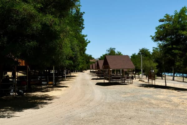
Whiting Campground sits about three miles from Mapleton at roughly 5,400 feet, in a dense grove of maple and cottonwood with a perennial creek running alongside. It offers hiking, mountain biking and horseback riding, and the Maple Canyon Trail begins nearby, leading into a small network of trails with canyon and mountain views.
The reason to flag it: the group sites are large. One group site accommodates up to 100 people and another up to 200. Both come with picnic tables, grills, campfire rings and cement pads. That is an unusual capacity for a Forest Service site this close to Provo, and it makes Whiting a real candidate for a large family reunion, ward activity or company event — the kind of gathering that usually ends up in a rented hall.
There are also single-family and equestrian sites, the equestrian ones with hitching racks, which fits Mapleton's long horse culture. Vault toilets are provided.
The approach is from I-15 Springville exit 260, east through Springville and Mapleton, then east on 400 North for a couple of miles to the campground. Reservations run through recreation.gov, and the usual change-and-cancellation fees apply.
Go in fall. The maple and cottonwood grove is the point, and it turns. Our fall colors guide covers timing across the valley.
Mapleton, above the freeway
Mapleton is a bench town with an unusual amount of horse property and a deliberate history of resisting density. It is not a place with a commercial strip to browse.
What it has is access. The canyon is minutes away. Hobble Creek Canyon — with its golf course, its picnic grounds and its own long drive up to Jolley's Ranch — is next door via Springville, and has its own full guide. The bench roads themselves are among the better cycling in the county, quiet and steadily climbing with the whole valley opening up behind you.
Mapleton City Days runs in summer with the standard parade, park program and fireworks shape.
The honest framing: Mapleton is a place you drive through to reach a canyon, or a place you live. It is not a destination in itself, and residents mostly prefer it that way.
Salem Pond, and Pond Town
Salem was originally called Pond Town, and the pond is still the middle of everything.
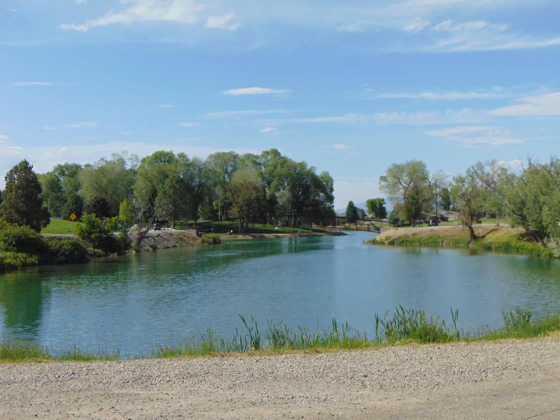
Salem Pond carries a walking loop, fishing, and the city's park facilities around its edge. It is small, it is pleasant, and it functions as the town square in a way an actual square would in an older settlement — the place where the community physically gathers.
For visitors, the pond is a good short stop rather than a half-day. It is a loop walk, a picnic, some ducks and a fishing line. Families with small children get more out of it than anyone else. It stocks well enough to be worth a rod; our fishing near Provo guide covers the local water generally.
Salem Days takes over the town each summer, and like every celebration on this list it follows the Utah County template.
Above Salem, the country rises toward Loafer Canyon and Mount Loafer, which is quieter and less traveled than the Timpanogos side of the valley by a wide margin. This is uncrowded ground — the trade being that it is also less developed, less signposted, and less forgiving if you are casual about preparation.
Santaquin, the orchard town that still has orchards
Santaquin is the most interesting of the three, for one specific reason.
The festival name is still accurate. Payson's Golden Onion Days commemorates an onion industry that is commercially gone. Pleasant Grove's Strawberry Days commemorates strawberries that are gone. Santaquin's Orchard Days commemorates orchards that are still there, on the bench above town, still producing.
That makes the Santaquin–Payson fruit belt the last working agricultural landscape of its kind in Utah County, and several operations run u-pick in season. Our u-pick orchards guide covers who does what and when.
Season timing is the thing people get wrong. Cherries, peaches and apples ripen at different points across a window that shifts every year with the weather. Check with the individual farm the week you plan to go. A u-pick trip planned from last season's dates is how families end up at a closed gate.
Santaquin Canyon and Tinney Flat
Behind the town, Santaquin Canyon climbs toward the Nebo country, and Tinney Flat Campground sits at around 7,000 feet alongside Santaquin Creek.
The elevation is the selling point. Seven thousand feet in July is a materially different experience from the valley floor, and Tinney Flat holds both intimate single sites under trees and group areas suited to family reunions. Wildlife sightings are common enough to be worth carrying a camera for.
From here the Nebo Loop Scenic Byway is the natural continuation — one of the best drives in Utah and the subject of its own guide, climbing past Mount Nebo, the highest peak in the Wasatch Range.
Orchard Days runs in early August, with an RMPRA rodeo, a grand parade, a 5K through the orchards and fireworks; see our Orchard Days guide for the schedule and the reason third-party listings keep getting the dates wrong.
How to plan a day down here
The mistake is treating these as three separate destinations. They are one corridor, and the efficient move is one canyon plus one town thing.
A fall day: drive to Whiting Campground for the maples, walk the Maple Canyon Trail, then come back through Springville for lunch and the Springville Museum of Art, which is free and fifteen minutes away.
A summer day with kids: Salem Pond in the morning for the loop and the ducks, then south to the Santaquin bench for u-pick fruit in the afternoon.
A hot day: skip the valley floor entirely. Go straight up Santaquin Canyon to Tinney Flat, eat there, and continue onto the Nebo Loop for the afternoon. You gain several thousand feet and lose a great deal of heat.
A big group: book a Whiting group site well ahead. Very few places this close to Provo will take a hundred people outdoors with tables and fire rings already in place.
What to expect, honestly
Bring what you need. These are small towns. Santaquin and Salem have basic services and Mapleton has very little commercially; the canyon campgrounds have vault toilets and no potable water as a rule. Fill up, and buy food before you leave the freeway corridor.
Signal is unreliable in the canyons. Download maps before you turn off the highway, particularly for Santaquin Canyon and anything on the Nebo Loop.
Check road status seasonally. The Nebo Loop closes in winter, and canyon roads at this end are lower priority for plowing than the main corridors. Our notes on winter driving in the canyons apply.
Fees and reservations change. Forest Service campgrounds adjust rates and reservation windows, and figures quoted anywhere online age badly. Confirm on recreation.gov before you drive.
Why this end of the valley is worth the drive
The south valley is what Utah County looked like before the north end filled in — small towns with visible agriculture, canyons you can park in without circling, and celebrations still named for what the town did.
It is changing. Growth is pushing south along I-15 the way it has already pushed north, and the orchards on the Santaquin bench are worth more as subdivisions than as fruit. That tension is real and it is discussed openly in these towns.
Which is a reasonable argument for going now rather than eventually.
The history under the three towns
Each of these places was founded for a specific physical reason, and in all three cases the reason is still visible if you know where to look.
Salem's pond came first. The settlement was called Pond Town because a natural body of water sat where the park is now, and in a valley where every early community organized itself around water rights, that pond was the entire argument for putting a town there. The name changed; the pond stayed the center. Very few Utah settlements have kept their founding feature so literally intact — most turned their creeks into culverts and their springs into culinary systems decades ago.
Mapleton's maples gave it its name, and the canyon behind town is where they are. The bench position was chosen for the same reason bench positions were chosen all along the Wasatch: good drainage, gravity-fed water from the canyon, and ground that drains rather than floods. The horse property that characterizes the town today is a direct descendant of that agricultural layout — large lots, irrigation ditches, and a road grid built for wagons rather than subdivisions.
Santaquin's orchards are on the bench for a microclimate reason that is interesting. Fruit trees are vulnerable to late spring frost, and cold air is dense — it drains downhill and pools on valley floors. A bench partway up a slope sits above that pool of cold air, in what growers call a thermal belt. That is why the orchards are where they are rather than on the flat ground below, and it is why the fruit belt survived here after similar industries failed elsewhere in the county. The geography is doing work that no amount of effort on the valley floor could replicate.
All three towns also share a settlement pattern worth noticing on the ground: wide streets on a grid, deep lots, and irrigation running through neighborhoods. That is the standard Utah plat layout, and at this end of the valley it has been overwritten far less than it has in Provo or Orem.
When to come, month by month
Timing matters more down here than in the north county, because most of what is worth doing is outdoors and seasonal.
April and May — the bench comes alive and the orchards blossom, which is beautiful and almost entirely unphotographed by anyone outside the towns. Canyon roads may still be gated at elevation. Salem Pond is pleasant and quiet.
June — canyons open properly. Whiting is at its greenest, the creek is running hard with snowmelt, and the high country is still too wet in places. City celebration season begins.
July and August — the hottest stretch on the valley floor and therefore the best argument for elevation. Tinney Flat at 7,000 feet is the move. Orchard Days runs in early August, and stone fruit comes in across the Santaquin bench through late summer. Book group sites well ahead; this is when Whiting's large sites go.
September and October — the best window overall. Apples on the bench, the Nebo Loop at its peak, and the maples in Mapleton's canyon turning. Crowds thin sharply after Labor Day while the weather stays good for weeks.
November through March — the canyons largely shut down. The Nebo Loop closes, campgrounds close, and the towns go quiet. There is little reason to make the drive unless you live here, which is exactly why residents like this half of the year.
Horse country, and what that means for a visitor
Something a visitor notices immediately at this end of the valley and rarely gets explained: there are a lot of horses.
Mapleton in particular retains substantial equestrian property, and the south valley generally has kept the large-lot pattern that makes keeping animals practical. This is not decorative. It shapes the recreation infrastructure in ways that matter even if you have never sat on a horse.
Trails here are frequently multi-use. The Maple Canyon Trail is signed for hiking, mountain biking, dirt biking and horseback riding all at once, which is a mixed corridor and requires more courtesy than a hiking-only path. Whiting has dedicated equestrian sites with hitching racks, which is a facility most Utah County campgrounds do not offer.
The etiquette, briefly, because people get it wrong. Horses are prey animals and they spook. If you are on foot, step to the downhill side of the trail, stop, and speak — a normal voice tells the animal you are a person rather than a predator. If you are on a bike, stop completely and let the rider tell you what they want; do not coast past quietly, because a silent fast-moving object is the single worst thing you can be near a horse. Riders almost always have right of way.
If you want to ride rather than dodge, our horseback riding guide covers the stables and outfitters operating across the valley, several of them at this end.
Related Guides
- The Nebo Loop Scenic Byway
- U-Pick Orchards in Santaquin and Payson
- Hiking Mount Nebo
- Hobble Creek Canyon
- Orchard Days: Santaquin's Rodeo Week
- Camping Near Provo
- Living in Mapleton, Utah
- Living in Santaquin, Utah
Frequently Asked Questions
Is Maple Canyon in Mapleton the same as the famous climbing canyon?
What is Whiting Campground?
What is there to do in Salem?
Where is Tinney Flat?
Are the Santaquin orchards open to the public?
Do these towns have their own celebrations?
Is it worth driving down from Provo?
How far is the south valley from Provo?
Sources
The facts in this guide were checked against these sources. Hours, fees and rules change, so confirm anything time-sensitive with the source before you go. How we make Provo.com.
- Whiting, Uinta-Wasatch-Cache National Forest, Recreation.gov (USDA Forest Service). Checked October 12, 2026.
- Whiting Campground, USDA Forest Service, Uinta-Wasatch-Cache National Forest. Checked October 12, 2026.
- Tinney Flat, Uinta-Wasatch-Cache National Forest, Recreation.gov (USDA Forest Service). Checked October 12, 2026.