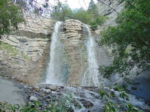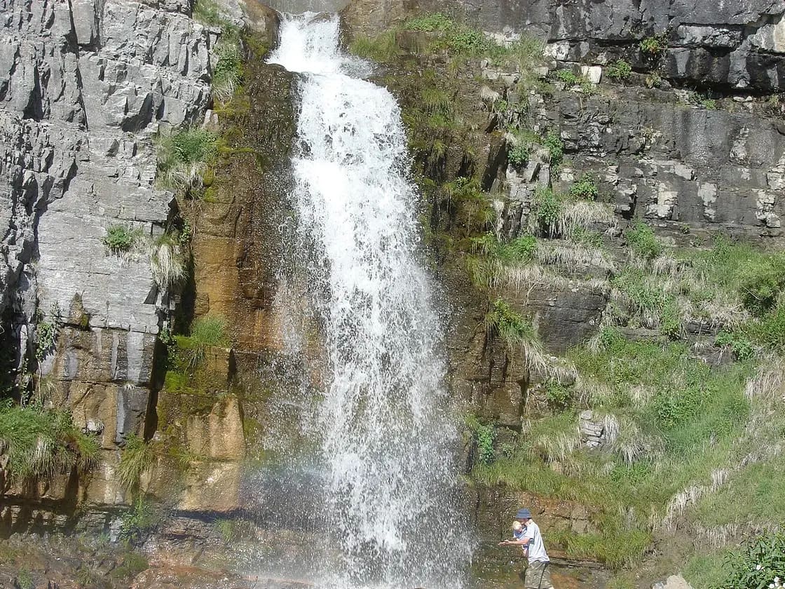

If someone in Utah Valley has done exactly one waterfall hike that isn't Bridal Veil Falls, it is this one. Stewart Falls sits on the back side of Mount Timpanogos above Sundance, a two-tiered cascade fed by snowmelt off the mountain, and the walk to reach it is the rare Wasatch hike that delivers a genuine payoff without demanding a genuine sufferfest.
It is also, quietly, the hike this valley is worst at describing accurately. So let's start there.
Why every source gives you a different distance
Look up this trail and you will find it listed at 3.2 miles, 3.4, 3.5, 3.6, 3.8 and 4 miles round trip, with elevation gain published anywhere from about 646 feet to nearly 900. Hikers tracking it on their own devices regularly come back with five.
None of those numbers are exactly wrong, and the reason is worth knowing before you go: the trail delivers you to a viewpoint, and then people keep walking. The path arrives with the falls in front of you across a drainage, and from there you can scramble down and closer toward the base. How far downstream you go is a decision you make in the moment, and it is the single biggest variable in what your watch says at the end.
The Forest Service's own figure is 1.9 miles to the falls, or about 3.8 miles round trip, and it says the trail ends at the falls; the social routes that climb around them are steep and dangerous.
The practical answer: plan for something in the 3.5 to 4 mile range and budget 1.5 to 3 hours. If you are the sort of person who will absolutely climb down to stand under the water, budget toward the top of both.
Similarly, the falls are two-tiered, but the height quoted for them varies widely from source to source, so don't plan around a number.
The sign problem, which is the single most useful thing on this page
The Aspen Grove parking area serves more than one trail, and the two that matter start within a hundred yards of each other.
The sign for your hike reads "Stewart Cascades," not "Stewart Falls." That trips people up constantly, because every map, blog and conversation calls it Stewart Falls.
The trail that continues straight ahead from the lot is the Aspen Grove route up Mount Timpanogos — a summit hike well over twelve miles round trip, and emphatically not a family afternoon. People do start up it by accident.
From the lot, head past the restrooms, find the Stewart Cascades sign, and follow it roughly a hundred yards until the trail turns sharply left into the pines. Shortly after, you will pass a round covered concrete water tank on your left that serves Aspen Grove — that is your confirmation you are on the right path.
If you want the full picture on the mountain itself, our Mount Timpanogos hike guide covers the summit route properly.
What the trail is like
It is a rolling trail rather than a climbing one. You gain and give back elevation repeatedly through the forest, which is pleasant on the way out and slightly annoying on the way back, because the return is not all downhill — a fact that surprises people who assumed they had banked the climb.
The first stretch runs through pine, which gives way to long stands of aspen with ferns growing underneath. The aspens along here are visibly curved at the base in places, which is avalanche history written into the trees.
Then it opens. The middle section crosses meadow with the canyon falling away behind you, and in high summer this stretch carries real wildflower density. It is also the exposed part — the shade largely ends, and on a hot afternoon you feel it.
Stinging nettle grows along sections of the trail, in places thick enough to crowd the edge. Long trousers are not a bad call, and it is a specific reason to keep kids from wandering off the path.
Near the end the falls come into view across the drainage, and the last stretch is the descent toward them.
Comparing it to the other falls nearby
If you are deciding between this and the shorter options, our roundup of waterfalls in Utah Valley sorts them by effort and covers the fee areas.
At the falls
The trail brings you to the drainage with the cascade opposite, and this is where the hike stops being a walk and starts being a destination.
The water comes off the back of Timpanogos as snowmelt, which means two things. It runs hardest early — June is the month people photograph — and it is startlingly cold year-round. This is not a swimming hole. People do walk down to the base and, when the flow allows, along the rock behind and beneath the falling water, and the standard reaction is an involuntary noise followed by a fast exit. It is memorable. It is also the point where footing matters most, on wet rock with spray on it.
There is a piece of trail folklore attached to this one, which locals will tell you with varying degrees of a straight face: cross behind the falls without touching the water and you are married on the spot. Given where you are — a valley whose defining demographic fact is how young people marry here — it is a joke with unusually deep roots. Nobody has ever explained how you are supposed to manage the not-touching part.
Practically: the rock is slick, the spray reaches further than it looks, and the drop below the crossing is real. This is the section to be sensible about, particularly with kids and particularly in high flow.
Crowds, and the honest way around them
This is one of the most heavily trafficked trails in the Wasatch, and pretending otherwise does nobody any favors. On a July Saturday you will meet a continuous stream of people in both directions, and the parking lot is the choke point rather than the trail.
What works:
Go on a weekday. The difference is not marginal, it is categorical. Midweek in the same month can feel like a different trail.
Go early. Before 8 a.m. solves parking and heat in one move, and the light through the aspens is better anyway.
Go late in the season. Once the school year starts and the August peak passes, the trail thins out considerably while the hiking gets better rather than worse.
Take the lift. The Sundance approach spreads people differently and removes the parking problem entirely.
What does not work is arriving at 11 a.m. on a Saturday in July and hoping. That is the version of this hike people come back complaining about, and the complaint is about the crowd rather than the trail.
The other way in: the Sundance chairlift
Most people walk from Aspen Grove. You don't have to.
Sundance Mountain Resort runs its scenic chairlift up to Ray's Summit in the warm months, and from there the trail signs point toward Stewart Falls. It turns the outing into something closer to a scenic ride with a walk attached, and the lift itself hands you panoramic views back down Provo Canyon that the Aspen Grove trail never gives you.
The trade-offs are honest ones: it costs a lift ticket rather than a parking fee, it is bound by lift operating hours, and the distance changes depending on where you start and finish. Check current lift hours and pricing with the resort directly before you plan around it — that operation is seasonal and the schedule moves.
This is a good option with older relatives in tow, or when you want the outing to be an event rather than a workout.
Fees, parking and getting there
The trailhead is the Aspen Grove parking area on the Alpine Loop road (UT-92), past the fee station, near the Theater-in-the-Pines picnic area and the BYU Aspen Grove camp. From Provo or Orem it is roughly 30 to 40 minutes: US-189 up Provo Canyon, then UT-92 toward Sundance and on past the resort.
There is a Forest Service recreation fee for the area, and federal passes are honored. Published day-use amounts differ between sources, and older figures circulate widely enough that we are not going to quote one as current — confirm at the fee station or with the Uinta-Wasatch-Cache National Forest. If you are also visiting Timpanogos Cave or spending the day in American Fork Canyon, it is worth understanding how the multi-day passes work before you pay twice.
Parking is the real constraint. This is one of the most heavily used trailheads in the valley, and the lot fills on summer weekends — Saturdays especially. The fix is the same as it is for every popular Wasatch trailhead: go early, or go on a weekday.
Restrooms are at the trailhead.
Dogs are allowed on leash, which is not true everywhere on this mountain and makes this a default choice for people hiking with a dog.
When to go
June is the waterfall at full volume, with the snowmelt behind it and the meadows lush.
July and August bring wildflowers and heat. The shaded first mile is a genuine asset here, but the open middle section is not, so start early — the same rule that governs every exposed trail in this valley in midsummer.
Late September into early October is arguably the best of it. The aspens turn, the crowds thin from their August peak, and the temperature settles into something ideal for a rolling trail. Our fall guide covers how the color timing works across the canyons.
Spring is the wildcard. Snow lingers up here well past the point where the valley floor has dried out, and avalanche debris can sit across the trail into early season. It is hikeable earlier than most people assume and messier than most people expect.
Winter closes the question, because the Alpine Loop road shuts seasonally and access from that side ends with it. See the Alpine Loop guide for how that road's season works.
Doing it with kids
This is one of the more family-viable real hikes in Utah Valley, with caveats.
In its favor: no sustained climb, shade for the first stretch, a spectacular and obvious destination that gives kids something to walk toward, restrooms at the start, and a turnaround point you can take at whatever pace you like.
Against it: it is still around four miles, the rocky sections are real trip hazards, the nettle is unpleasant, and the final descent toward the base of the falls is the part where you will want hands free and attention on.
The common-sense version — plenty of valley families do this with school-age kids and it goes fine. Toddlers on their own feet will not make four miles, and a carrier on a rocky rolling trail is more work than it sounds.
A note on the name
You will see this trail signed and cataloged several ways, which is worth knowing if you are cross-referencing maps. The trailhead sign says Stewart Cascades. Forest Service and mapping references carry it as a numbered trail in the Uinta-Wasatch-Cache system. Trail apps list separate entries depending on whether the route starts at Aspen Grove or comes across from the Sundance side, with different distances attached to each — which is a second reason the published numbers vary so widely, on top of the how-far-you-scramble question.
Locally, everyone says Stewart Falls, and everyone means the same waterfall.
What to bring
- More water than you think. The open middle section and the elevation combine to dehydrate people faster than a 3.5-mile number suggests.
- Real shoes. The trail is well maintained but rocky in stretches, and can be muddy in spring.
- Sun protection. The shade runs out.
- Long trousers if you are nettle-averse or hiking with children.
- A layer. You are starting near 6,900 feet, and mornings up here are cool even in July.
- Poles, if balance on uneven ground is a concern — the rocky middle miles are where people want them.
Five ways people get this hike wrong
They take the wrong trail out of the parking lot. The Timpanogos summit route leaves from the same lot, and the sign you want says Stewart Cascades. This is the most common error and the most consequential — one of those trails is four miles and one is over twelve.
They treat the distance as the difficulty. Three and a half miles reads as easy, so people arrive in flip-flops with a single small water bottle. The trail is rolling, rocky in stretches, sits near 7,000 feet, and turns exposed halfway. It is not hard, but it is a hike rather than a walk.
They assume the way back is downhill. It isn't, entirely. The rolling profile that makes the outbound leg pleasant means you climb on the return too. People plan their remaining water around a descent that doesn't exist.
They arrive at midday on a summer Saturday. Then they write a review about the crowds. The trail is not the problem; the timing is, and it is entirely fixable.
They underestimate the water. The pool below the falls is snowmelt off the back of a 11,000-foot mountain. It does not warm up in August. The rock around it stays wet, and the spray reaches further than it looks from the viewpoint.
None of these are exotic. They are the same five mistakes made on this trail every summer weekend, and knowing them in advance is most of what separates a good morning from a grim one.
Where it fits among the valley's hikes
Stewart Falls occupies a useful slot: harder than a paved stroll, far easier than a summit, and with a payoff at the end that is worth the effort in a way that a viewpoint sometimes isn't.
If you want the waterfall without the walk, Bridal Veil Falls is the answer and it is not close. If you want the mountain rather than the water, the Timpanogos summit route leaves from the same parking lot and is an entirely different commitment. If you want a ticketed, scheduled outing with an underground payoff, the Timpanogos Cave trail is a steeper climb over a shorter distance.
For everything else in the valley sorted by effort, our complete Provo hiking guide is the place to start.
Trail distances, fees and lift schedules change, and published figures for this trail disagree with each other. Confirm current conditions with the Uinta-Wasatch-Cache National Forest before you go.
Related Guides
- Battle Creek Falls: The Complete Hike Guide (2026)
- Lesser-Known Hikes Near Provo: Six Trails Past the Famous Five (2026)
- Bonneville Shoreline Trail: The Provo & Orem Guide (2026)
- Provo Peak: The Mountain Behind the Y, and Why the Road Is the Hard Part
- Y Mountain Trail: The Complete Hiking Guide (2026)
- Utah Valley Hike Finder — filter every trail by difficulty, length, season, dogs and fees
Frequently Asked Questions
How long is the Stewart Falls hike?
How hard is the Stewart Falls trail?
Where does the Stewart Falls trail start?
Do you have to pay to hike Stewart Falls?
When is the best time to hike Stewart Falls?
Sources
The facts in this guide were checked against these sources. Hours, fees and rules change, so confirm anything time-sensitive with the source before you go. How we make Provo.com.
- Stewarts Cascade Trail #056, USDA Forest Service, Uinta-Wasatch-Cache National Forest. Checked October 12, 2026.
- Mount Timpanogos Trailhead (Aspen Grove), USDA Forest Service, Uinta-Wasatch-Cache National Forest. Checked October 12, 2026.
- Theater IN The Pines, Uinta-Wasatch-Cache National Forest, Recreation.gov (USDA Forest Service). Checked October 12, 2026.
- Stewart Falls Lower Trail, AllTrails. Checked October 12, 2026.